Certified Global Research Member


Key Questions Answered
- Global Market Outlook
- In-depth analysis of global and regional trends
- Analyze and identify the major players in the market, their market share, key developments, etc.
- To understand the capability of the major players based on products offered, financials, and strategies.
- Identify disrupting products, companies, and trends.
- To identify opportunities in the market.
- Analyze the key challenges in the market.
- Analyze the regional penetration of players, products, and services in the market.
- Comparison of major players’ financial performance.
- Evaluate strategies adopted by major players.
- Recommendations
Why Choose Market Research Future?
- Vigorous research methodologies for specific market.
- Knowledge partners across the globe
- Large network of partner consultants.
- Ever-increasing/ Escalating data base with quarterly monitoring of various markets
- Trusted by fortune 500 companies/startups/ universities/organizations
- Large database of 5000+ markets reports.
- Effective and prompt pre- and post-sales support.
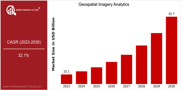
Market Size Snapshot
| Year | Value |
|---|---|
| 2023 | USD 22.1 Billion |
| 2030 | USD 52.7 Billion |
| CAGR (2024-2032) | 32.1 % |
Note – Market size depicts the revenue generated over the financial year
Geospatial Imagery Analytics Market is expected to grow significantly, with a current value of $22.1 billion in 2023, which is expected to reach $52.7 billion by 2030. This is a compound annual growth rate (CAGR) of 32.1 % from 2024 to 2032, which indicates a strong demand for advanced geospatial image analysis solutions in various industries. In particular, the increasing use of satellite images, drones and machine learning-based analysis is driving this growth, as companies increasingly seek to leverage geospatial data for improved decision-making and operational efficiency. The main factors driving this market are the increasing need for real-time data in urban planning, environmental monitoring and disaster management, and the development of machine learning and big data analysis. The key players in this market are Maxar Technologies, Planet Labs and Esri. They are investing in new technology and forming strategic alliances to provide advanced services. For example, Maxar has recently teamed up with the government to provide high-resolution images.
Regional Market Size
Regional Deep Dive
The Geographic Imagery Analytics Market is growing at a fast pace in various regions of the world, driven by the increasing demand for location-based services and the proliferation of big data. In North America, the market is characterized by the presence of a large number of key players and government initiatives that promote the use of spatial data for urban planning, disaster management, and environment monitoring. In Europe, the market is characterized by the emergence of regulatory frameworks that encourage the integration of spatial data in various sectors, while in Asia-Pacific, the geographical imagery analysis market is growing rapidly due to urbanization and the development of the built environment. The Middle East and Africa are exploiting the potential of geographical imagery analysis for resource management and security, while Latin America is beginning to explore its potential in agriculture and environment protection.
Europe
- The European Space Agency (ESA) has started the Copernicus program, which provides free access to satellite data. This program has a major impact on the geospatial analytics market, since it enables different industries to use this data for the purpose of environment and disaster monitoring.
- Regulatory changes, such as the EU's Digital Single Market strategy, are promoting the use of geospatial data across member states, enhancing collaboration and innovation in the analytics sector.
Asia Pacific
- Countries like China and India are investing heavily in satellite technology and geospatial analytics, with initiatives such as China's BeiDou Navigation Satellite System enhancing the region's capabilities in location-based services.
- The rise of smart cities in Asia-Pacific is driving demand for geospatial analytics, as urban planners and local governments seek to optimize infrastructure and services through data-driven insights.
Latin America
- Brazil is leveraging geospatial analytics for agricultural monitoring and environmental conservation, with initiatives like the Amazon Fund promoting sustainable practices through data-driven insights.
- The region is witnessing a growing interest in geospatial technologies among startups, with companies focusing on innovative applications in urban planning and disaster management.
North America
- The U.S. government has launched several initiatives, such as the National Geospatial-Intelligence Agency's (NGA) 'Project Maven', which aims to enhance the use of AI in analyzing geospatial data, thereby driving innovation in the market.
- Companies like Maxar Technologies and Planet Labs are leading the charge in satellite imagery and analytics, providing high-resolution data that is crucial for sectors like agriculture, defense, and urban planning.
Middle East And Africa
- The UAE's Vision 2021 emphasizes the use of geospatial data for urban development and sustainability, leading to increased investments in geospatial analytics technologies.
- Countries like South Africa are utilizing geospatial analytics for resource management and environmental monitoring, supported by government programs aimed at enhancing data accessibility and usage.
Did You Know?
“Did you know that the global geospatial analytics market is expected to reach over $100 billion by 2025, driven by the increasing adoption of IoT and AI technologies?” — Market Research Future
Segmental Market Size
The Geospatial Imagery Analytics Market is experiencing a rapid growth owing to the rising demand for location-based insights in the various industries. The major driving factors for this market are the increasing need for data-driven decision-making in the various industries such as agriculture, urban planning, and disaster management. The advancements in the satellite and drone technology have enhanced the data collection capabilities. The government regulations and mandates promoting the monitoring of the environment and land use planning are also boosting the demand for the geospatial imagery analytics solutions. The market is currently in the commercialization stage. Companies such as Planet Labs and Maxar Technologies are leading the way in providing high-resolution imagery and data analytics services. The major applications of the geospatial imagery analytics solutions are in the agriculture and urban planning domains. The trends such as the smart city and the green economy are also promoting the growth of the market. The advancements in the machine learning and artificial intelligence are revolutionizing the data collection and processing capabilities, enabling the solutions to deliver more accurate and timely insights.
Future Outlook
The Geospatial Imagery Analytics Market will have a positive CAGR of 32.1 percent from 2023 to 2030. The rise in the market will be largely driven by the increased adoption of advanced analytics and artificial intelligence (AI) technology, which will increase the capabilities of the interpretation of geospatial data. The penetration of these solutions will increase significantly as more industries such as agriculture, urban planning, and disaster management recognize the value of geospatial data. By 2030, the penetration of these solutions is expected to reach more than 60 percent in the key industries. Further technological advancements, such as the integration of machine learning algorithms and the proliferation of satellite imagery, will also drive the market. The introduction of smart cities and the monitoring of the environment will also create a favorable environment for the development of the market. The growing demand for real-time data and the growing emphasis on sustainability will also shape the future of the market. As more and more organizations look to data to make strategic decisions, the market will evolve to provide more solutions for diverse applications and drive overall growth in the future.
Covered Aspects:| Report Attribute/Metric | Details |
|---|---|
| Market Size Value In 2022 | USD 20.4 Billion |
| Market Size Value In 2023 | USD 22.1 Billion |
| Growth Rate | 32.1% (2023-2030) |
Geospatial Imagery Analytics Market Highlights:
Leading companies partner with us for data-driven Insights
Kindly complete the form below to receive a free sample of this Report
Tailored for You
- Dedicated Research on any specifics segment or region.
- Focused Research on specific players in the market.
- Custom Report based only on your requirements.
- Flexibility to add or subtract any chapter in the study.
- Historic data from 2014 and forecasts outlook till 2040.
- Flexibility of providing data/insights in formats (PDF, PPT, Excel).
- Provide cross segmentation in applicable scenario/markets.