Remote Sensing Software Market Overview
Remote Sensing Software Market is projected to grow from USD 15.74 Billion in 2025 to USD 49.41 Billion by 2034, exhibiting a compound annual growth rate (CAGR) of 13.55% during the forecast period (2025 - 2034). Additionally, the market size for Remote Sensing Software Market was valued at USD 13.86 billion in 2024.
Key Remote Sensing Software Market Trends Highlighted
The global remote sensing software market is witnessing notable advancements driven by the increasing integration of artificial intelligence (AI) and machine learning (ML) technologies. These technologies enhance data analysis capabilities, enabling more accurate and rapid processing of vast amounts of imagery and data. Furthermore, the growing adoption of cloud-based platforms is providing greater accessibility and flexibility in accessing and managing remote sensing software, catering to the growing demand for data-driven insights.
The market is also witnessing a shift towards specialized software solutions tailored to specific industries, such as agriculture, forestry, and urban planning, as businesses seek to leverage remote sensing data for targeted decision-making.
Fig 1: Remote Sensing Software Market Overview
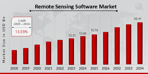
Source: Primary Research, Secondary Research, Market Research Future Database and Analyst Review
Remote Sensing Software Market Drivers
Increasing Demand for Remote Sensing Data in Various Applications
The software is the main asset of remote sensing. Indeed, remote sensing software supports the acquisition of thematic information from various remote sensing platforms, whether it be satellites, drones, or airborne sensors. Further, the increased use of remote sensing technology in agriculture, forestry, environmental monitoring, urban and disaster control, as well as other areas, will significantly increase the demand for the software.
Besides, due to the given software, information is obtained about various processes, which makes it possible to identify, monitor, and analyze the Earth’s surface, its resources, and environment. Since the level and speed of changes on the Earth's surface are constantly increasing, information should be accurate, up-to-date, and qualitative. Due to this fact, the demand for remote sensing software is expected to increase for many years.
Advancements in Cloud Computing and Artificial Intelligence
The industry is witnessing significant advancements in cloud computing and artificial intelligence. Cloud computing technology is now helping to offer scalable and cost-effective solutions for storing, processing, and analyzing a tremendous amount of remote sensing data. On the other hand, AI is also integrated within the remote sensing software to introduce capabilities like automatic feature extraction, image classification, and object detection. Thanks to these advancements, the process of analyzing remote sensing data is becoming more efficient and accurate, being accessible and valuable for a broader range of users.
The integration of cloud computing and AI is expected to further drive the growth of the market in the upcoming years because these two technologies help the users get more actionable insights from remote sensing data with ease.
Government Initiatives and Regulations
Government initiatives and regulations play a significant role in shaping the global remote sensing software market. Governments worldwide are recognizing the importance of remote sensing technology for various applications, such as land use planning, natural resource management, and disaster response. They are implementing policies and regulations that encourage the adoption of remote sensing software and promote its use in decision-making processes. Additionally, governments are investing in research and development to advance remote sensing technologies and make them more accessible to users.
These initiatives and regulations are expected to positively influence market growth as they create a supportive environment for the adoption and utilization of remote sensing software.
Remote Sensing Software Market Segment Insights
Remote Sensing Software Market Application Insights
The global remote sensing software market is segmented by application into land cover mapping, precision agriculture, forestry management, disaster management, and water resource management. Land cover mapping is expected to hold the largest market share in the global remote sensing software market during the forecast period. In 2023, the market value for Land Cover Mapping was observed at USD 3.165 billion, and it is projected to reach USD 10.264 billion by 2032, exhibiting a CAGR of 14.25%.
This growth can be attributed to the increasing demand for accurate and timely information on land use and land cover changes for various applications, such as urban planning, environmental monitoring, and agriculture.
Precision agriculture is another significant application segment in the global remote sensing software market. It held a market value of USD 2.155 billion in 2023 and is anticipated to register a CAGR of 13.87% to reach USD 6.73 billion by 2032. Precision agriculture involves using remote sensing data to optimize crop production by providing farmers with insights into soil conditions, crop health, and yield forecasting. Forestry management is a crucial application segment in the global remote sensing software market, with a market value of USD 1.916 billion in 2023.
It is projected to register a CAGR of 13.65% to reach USD 5.884 billion by 2032. Remote sensing data is extensively used in forestry management for tasks such as forest inventory, deforestation monitoring, and habitat assessment. Disaster management is a rapidly growing application segment in the global remote sensing software market, driven by the increasing frequency and severity of natural disasters. In 2023, the market value for disaster management was estimated at USD 1.796 billion, and it is projected to reach USD 5.529 billion by 2032, exhibiting a CAGR of 13.45%.
Remote sensing data plays a vital role in disaster management activities, such as damage assessment, emergency response, and recovery planning. Water resource management was another important application segment in the global remote sensing software market, with a market value of USD 1.728 billion in 2023. It is anticipated to register a CAGR of 13.35% to reach USD 5.343 billion by 2032. Remote sensing data is used in water resource management for monitoring water availability, assessing water quality, and managing water infrastructure.
Overall, the global remote sensing software market is expected to witness significant growth in the coming years, driven by the increasing adoption of remote sensing technologies across various application segments. The market growth is supported by factors such as advancements in satellite technology, the proliferation of geospatial data, and the growing demand for accurate and timely information for decision-making in diverse industries.
Fig 2: Remote Sensing Software Market Insights
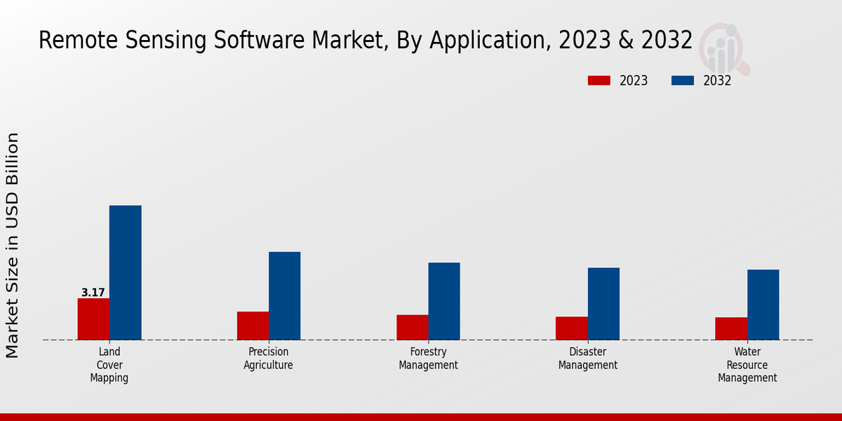
Source: Primary Research, Secondary Research, Market Research Future Database and Analyst Review
Remote Sensing Software Market Deployment Type Insights
The global remote sensing software market is segmented by deployment type such as Cloud-based and On-premises. Based on the report, in 2023, the Cloud-based segment dominated a larger share of the market and grow at a faster CAGR during the forecast. The growth of this segment is due to the increased adoption of cloud computing by enterprises. Additionally, users prefer this type of deployment because the cloud-based deployment is highly scalable, flexible and cost-effective.
In addition to that, providers prefer cloud-based deployment because it is possible to deploy and scale their software without the need to manage the physical hardware infrastructure.
Based on the report, in 2023, the On-premises segment is expected to grow at a slower pace accounting for a smaller share. The growth of this segment is because there are some enterprises that require that data must not leave the premise because of compliance requirements. In addition to that, some organizations have strict security requirements that they should store the data to comply with the data privacy laws.
The global remote sensing software market is expected to grow during the forecast period because the demand for remote sensing data is increasing and the adoption of cloud computing is also increasing.
Remote Sensing Software Market Data Source Insights
The global remote sensing software market segmentation by Data Source is categorized into Satellite Imagery, Aerial Imagery, Drones, Radar, and LiDAR. Satellite Imagery held the largest market share in 2023 and is anticipated to continue its dominance throughout the forecast period. The increasing adoption of satellite imagery in various applications, such as land use mapping, environmental monitoring, and disaster management, is driving the growth of this segment. Aerial Imagery, captured from aircraft or drones, offers high-resolution images and is gaining traction in applications such as urban planning, agriculture, and infrastructure monitoring.
Drones, equipped with sensors and cameras, provide real-time data collection and are witnessing growing demand in sectors such as construction, mining, and precision agriculture. Radar technology, utilizing electromagnetic waves, enables imaging in low-light conditions and is used in applications such as weather forecasting, oceanography, and defense. LiDAR, employing laser pulses, generates precise 3D data and is gaining popularity in applications such as terrain mapping, forestry, and autonomous vehicles.
The global remote sensing software market revenue from Satellite Imagery is projected to reach USD 6.32 Billion by 2024, while the market for Drones is expected to register a CAGR of 17.2% during the forecast period.
Remote Sensing Software Market End-User Industry Insights
The global remote sensing software market is segmented into various end-user industries, including agriculture, mining, oil and gas, transportation, construction, and others. Among these, the agriculture segment accounted for a significant share of the market in 2023, driven by the increasing adoption of precision farming techniques and the need for improved crop monitoring and yield estimation. The mining segment is also expected to witness substantial growth due to the rising demand for efficient and sustainable mining practices.
Additionally, the oil and gas industry is likely to contribute significantly to the market growth owing to the need for accurate exploration and monitoring of oil and gas reserves. Furthermore, the transportation and construction industries are expected to witness notable growth due to the increasing use of remote sensing software for infrastructure planning, management, and monitoring.
Remote Sensing Software Market Regional Insights
The regional analysis of the market shows that North America dominated the market in 2023 with a revenue share of 38.2%, followed by Europe with 29.4% and APAC with 25.1%. South America and MEA accounted for 4.6% and 2.7% of the market revenue, respectively. The growth of the North American market is attributed to the increasing adoption of remote sensing technologies in various industries, such as agriculture, forestry, and environmental monitoring. The presence of major players, such as Esri, Harris Geospatial Solutions, and Hexagon AB, further contributes to the growth of the market in this region.
The European market is also growing rapidly, driven by the increasing demand for remote sensing data in applications such as land use planning, disaster management, and climate change monitoring. The presence of key players, such as Airbus, Thales Group, and MDA, is also driving the growth of the market in this region. The APAC market is expected to witness significant growth in the coming years, due to the increasing adoption of remote sensing technologies in emerging economies, such as China, India, and Southeast Asia.
The growing demand for remote sensing data in sectors such as agriculture, mining, and infrastructure development is also driving the growth of the market in this region.
South America and MEA are expected to grow at a moderate pace during the forecast period. However, the growth in these regions is expected to be hindered by factors such as limited awareness about remote sensing technologies and a lack of skilled professionals.
Fig 3: Remote Sensing Software Market Regional Insights
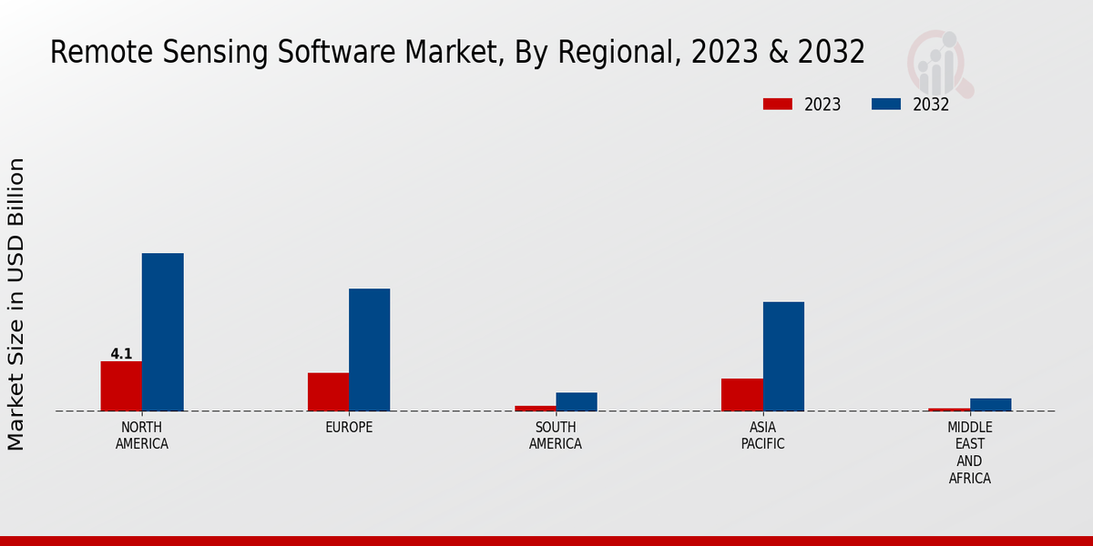
Source: Primary Research, Secondary Research, Market Research Future Database and Analyst Review
Remote Sensing Software Market Key Players and Competitive Insights
Major players in the remote sensing software market are constantly striving to gain a competitive edge through strategic partnerships, acquisitions, and product innovations. Leading remote sensing software market players are focusing on developing advanced solutions that cater to the evolving needs of various end-use industries. The remote sensing software market competitive landscape is characterized by a mix of established players and emerging start-ups, each offering unique capabilities and solutions. Key factors driving competition include technological advancements, data security concerns, and the increasing demand for real-time and accurate data analysis.
Collaborations between industry leaders and research institutions are also shaping the competitive dynamics of the remote sensing software market development.
Hexagon AB, a leading provider of sensors, software, and autonomous solutions, holds a significant position in the remote sensing software market. The company offers a comprehensive suite of remote sensing solutions under its Geospatial division, including ERDAS IMAGINE, Leica Geosystems, and Intergraph. Hexagon's strength lies in its advanced image processing capabilities, data management tools, and expertise in photogrammetry and LiDAR technology. The company caters to a wide range of industries, including agriculture, defense, and environmental monitoring. Hexagon's commitment to innovation and customer support has solidified its position as a key player in the remote sensing software market.
Airbus, a global leader in aerospace and defense, is another prominent player in the remote sensing software market. The company's Intelligence division provides a range of remote sensing software solutions, including SPOT Image, Pléiades, and TerraSAR-X. Airbus leverages its expertise in satellite imagery, radar technology, and data analytics to offer advanced solutions for land use planning, disaster management, and environmental monitoring. The company's strong partnerships with government agencies and commercial organizations have contributed to its growth in the remote sensing software market.
Airbus continues to invest in research and development to maintain its competitive advantage and meet the evolving needs of its customers.
Key Companies in the remote sensing software market Include
Remote Sensing Software Market Developments
The increasing adoption of remote sensing technologies across diverse sectors, including agriculture, forestry, environmental monitoring, and disaster management, is driving the market expansion. Moreover, advancements in cloud computing, artificial intelligence, and machine learning are further enhancing the capabilities of remote sensing software, making it more accessible and efficient for end-users. Key industry participants are focusing on strategic partnerships, acquisitions, and product innovations to gain a competitive edge in the market. Recent developments include the launch of new software platforms, integration of AI algorithms for improved data analysis, and collaborations with industry leaders to provide comprehensive solutions to customers.
Remote Sensing Software Market Segmentation Insights
Remote Sensing Software Market Application Outlook
- Water Resource Management
Remote Sensing Software Market Deployment Type Outlook
Remote Sensing Software Market Data Source Outlook
Remote Sensing Software Market End-User Industry Outlook
Remote Sensing Software Market Regional Outlook
|
Report Attribute/Metric
|
Details
|
|
Market Size 2024
|
13.86 (USD Billion)
|
|
Market Size 2025
|
15.74 (USD Billion)
|
|
Market Size 2034
|
49.41 (USD Billion)
|
|
Compound Annual Growth Rate (CAGR)
|
13.55% (2025 - 2034)
|
|
Report Coverage
|
Revenue Forecast, Competitive Landscape, Growth Factors, and Trends
|
|
Base Year
|
2024
|
|
Market Forecast Period
|
2025 - 2034
|
|
Historical Data
|
2019 - 2023
|
|
Market Forecast Units
|
USD Billion
|
| Key Companies Profiled |
Esri, Planet Labs, Airbus Defence and Space, Bentley Systems, Incorporated, Maxar Technologies, COMAP, Terrascan, Dassault Systemes, Topcon Positioning Systems Inc., Satimaging Corporation, Harris Geospatial Solutions, PCI Geomatics, Leonardo DRS, Hexagon AB, Trimble Inc. |
| Segments Covered |
Application, Deployment Type, Data Source, End-User Industry, Regional |
| Key Market Opportunities |
AI-driven data analysis Integration with cloud and big data platforms Advanced visualization and analytics capabilities Expansion into emerging markets Growing adoption in agriculture and environmental monitoring |
| Key Market Dynamics |
Growing demand for geospatial data, technological advancements, increasing government initiatives, environmental monitoring, and infrastructure development |
| Countries Covered |
North America, Europe, APAC, South America, MEA |
Frequently Asked Questions (FAQ):
The CAGR of the global remote sensing software market is expected to be 13.55% from 2025 to 2034.
The overall valuation of the global remote sensing software market is expected to reach USD 49.41 billion by 2034.
The overall valuation of the global remote sensing software market is expected to reach USD 18.68 billion by 2025.
North America is expected to hold the largest market share in the global remote sensing software market throughout the forecast period.
The agriculture segment is expected to hold the largest market share in the global remote sensing software market throughout the forecast period.
Some of the key competitors in the global remote sensing software market include Esri, Hexagon, Trimble, and Airbus.
Some of the key trends in the global remote sensing software market include the increasing adoption of cloud-based solutions and the growing demand for real-time data analytics.
Some of the challenges facing the global remote sensing software market include the high cost of implementation and the lack of skilled professionals.
Some of the opportunities for the global remote sensing software market include the growing demand for precision agriculture and the increasing use of remote sensing data in disaster management.
The global remote sensing software market reached USD 12.21 billion in 2023.

