US UAV LiDAR Market Overview
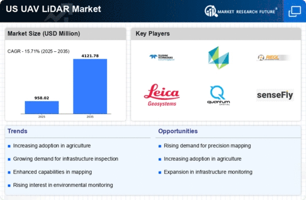
The US UAV LiDAR Market Size was estimated at 715.54 (USD Million) in 2023. The US UAV LiDAR Market Industry is expected to grow from 830(USD Million) in 2024 to 4,120 (USD Million) by 2035. The US UAV LiDAR Market CAGR (growth rate) is expected to be around 15.679% during the forecast period (2025 - 2035).

Source: Primary Research, Secondary Research, MRFR Database and Analyst Review
Key US UAV LiDAR Market Trends Highlighted
The US UAV LiDAR market is witnessing significant advancements driven by the increasing demand for accurate data collection and mapping in various sectors such as agriculture, forestry, and urban planning. One major market driver includes the growing adoption of UAVs for precision agriculture, where LiDAR technology improves crop monitoring and land management. Additionally, government initiatives promoting smart city developments and infrastructure projects are fueling investments in UAV LiDAR technology, enhancing its application in surveying and mapping tasks. There are also numerous opportunities available for companies operating within this sector.The integration of artificial intelligence and machine learning with UAV LiDAR systems presents a chance to enhance data processing capabilities, enabling faster and more efficient analysis. Furthermore, as environmental regulations tighten, there is a growing need for detailed topographical surveys for compliance purposes, leaving room for UAV LiDAR solutions to fill this gap. In recent times, trends such as increasing collaborations between technology firms and traditional surveying companies are emerging, resulting in innovative solutions that improve operational efficiency. Additionally, the development of lightweight and more versatile UAVs with advanced sensors is expanding the accessibility of LiDAR technology to smaller businesses and new industries.The US market is also seeing a rise in activities involving the use of UAV LiDAR for disaster management and recovery efforts, emphasizing its importance in real-time mapping and analysis for emergency response teams. Overall, the trends indicate a strong shift towards integrating UAV LiDAR technology into routine operations across multiple sectors, aligning with the evolving needs of data-driven decision-making in the US.
US UAV LiDAR Market Drivers
Increasing Demand for Accurate Geospatial Data
The US UAV LiDAR Market Industry is experiencing significant growth driven by the increasing demand for accurate geospatial data across various sectors, including agriculture, forestry, and urban planning. According to the United States Geological Survey, about 80% of all data in the National Map is associated with elevation information, underscoring the crucial role of accurate elevation data provided by LiDAR technology. The US government has initiated several programs to improve mapping accuracy, such as the 3D Elevation Program initiated by the US Geological Survey, which aims to collect high-quality topographic data for the entire United States.This initiative is expected to increase the demand for UAV LiDAR systems capable of capturing precise data over large areas efficiently. Established organizations like Trimble and Leica Geosystems are already investing in advanced UAV LiDAR technology to cater to this growing market need, indicating a clear trend towards enhanced data capture capabilities in the field.
Advancements in UAV Technology
Technological advancements in Unmanned Aerial Vehicles (UAVs) are propelling the growth of the US UAV LiDAR Market Industry. The Federal Aviation Administration has streamlined regulations surrounding UAV operations, providing more opportunities for businesses to integrate UAVs equipped with LiDAR technology into their operations. As of 2023, over 340,000 registered drones are reported in the US, according to the FAA. This increase in UAVs directly correlates with the rising adoption of LiDAR technology, as companies recognize the operational efficiencies and cost-effectiveness UAVs provide.Major manufacturers like DJI and Parrot are incorporating sophisticated LiDAR sensors in their UAV platforms to enhance imaging precision, thus driving further technological adoption within the market.
Government Investments in Infrastructure Development
Significant investments by the US government in infrastructure development initiatives are another major driver for the US UAV LiDAR Market Industry. With the Biden administration's plan to invest over USD 1 trillion in modernizing infrastructure, there is an increasing need for precise surveying and mapping capabilities that UAV LiDAR can provide. Specifically, the Infrastructure Investment and Jobs Act emphasizes the use of advanced technologies, including LiDAR, to ensure accurate assessments and planning.This commitment indicates a sustained demand for LiDAR technology to support and validate projects, fostering a favorable market environment for UAV LiDAR service providers and manufacturers. Companies like GeoCue are already strategically positioning themselves to capitalize on these government-funded projects.
Growing Adoption in Environmental Monitoring
The application of UAV LiDAR technology in environmental monitoring is witnessing robust growth, contributing positively to the US UAV LiDAR Market Industry. The United States Environmental Protection Agency (EPA) has highlighted the importance of high-resolution environmental data for assessments and monitoring of various environmental parameters such as forest health and coastal management. UAV LiDAR offers high accuracy in capturing environmental changes over time, and organizations are increasingly utilizing these systems to comply with regulatory requirements and improved decision-making.Studies show that accurate data regarding vegetation and topography can enhance habitat assessments, directly linking to how organizations like the Nature Conservancy employ UAV LiDAR in their environmental conservation projects. This growing adoption signals a favorable trajectory for the UAV LiDAR market in the United States.
US UAV LiDAR Market Segment Insights
UAV LiDAR Market Application Insights
The Application segment of the US UAV LiDAR Market encompasses various critical fields that leverage this technology for enhanced data collection and analysis, showcasing its significant role in modern industrial operations. Surveying stands out due to its necessity in providing accurate topographical data, which is essential for land development and engineering projects. Mapping benefits from the high-resolution data captured by UAV LiDAR, facilitating geographical information systems and spatial analysis that help in urban planning and environmental monitoring.Agriculture is rapidly adopting UAV LiDAR technology, as it offers insights into crop health, irrigation management, and yield estimation, contributing to the efficiency and sustainability of farming practices. The Forestry sector utilizes UAV LiDAR for forest inventory analysis, enabling better forest management, biomass estimation, and conservation efforts. In Infrastructure, UAV LiDAR aids in the assessment and maintenance of critical assets such as roads and bridges, identifying structural integrity and potential risks more accurately than traditional methods.Overall, these applications demonstrate the growing importance and increasing adoption of UAV LiDAR technology across multiple industries in the US, driving innovation and enhancing operational efficiency. The growth in these spaces is fueled by advancements in technology, demand for high-quality data, and the need for more efficient processes in an increasingly data-driven world. The US UAV LiDAR Market’s segmentation indicates a robust landscape of applications that address a variety of sectoral needs, ultimately pointing towards a thriving future.
Source: Primary Research, Secondary Research, MRFR Database and Analyst Review
UAV LiDAR Market Platform Type Insights
The US UAV LiDAR Market showcases a diverse platform type landscape, featuring Fixed-Wing UAV, Rotary-Wing UAV, and Hybrid UAV, each playing a crucial role in its growth trajectory. Fixed-Wing UAVs are known for their extended range and endurance, making them ideal for large-area mapping and topographic surveys, which aligns well with the increasing demand for efficiency in various applications. Rotary-Wing UAVs offer enhanced maneuverability and versatility, excelling in urban environments and specialized tasks such as infrastructure inspections.Meanwhile, Hybrid UAVs combine the advantages of both fixed and rotary platforms, providing unique capabilities that cater to a wide range of use cases, from agricultural monitoring to disaster response. As the US UAV LiDAR Market expands, advancements in technology and evolving regulations are expected to drive growth and adoption within these categories, leading to enhanced efficiency and data accuracy across industries such as construction, environmental monitoring, and agriculture. The increasing applications and versatility of each platform type contribute to their significant impact on the overall market dynamics, shaping the future of aerial surveying and mapping techniques in the US.
UAV LiDAR Market End Use Insights
The End Use segment of the US UAV LiDAR Market is gaining significant traction, driven by various sectors that recognize the technology's potential to enhance operational efficiency and data accuracy. In the Government sector, UAV LiDAR is extensively utilized for mapping and survey projects, which support urban planning and disaster management initiatives, demonstrating its critical role in public safety and infrastructure development. The Commercial segment is characterized by its focus on applications such as agriculture, forestry, and transportation, where precise data collection provides a competitive edge.The Defense sector is increasingly integrating UAV LiDAR for reconnaissance and surveillance operations, enhancing mission capabilities and situational awareness in various environments. Additionally, the Research and Development segment leverages UAV LiDAR technology for academic studies, environmental monitoring, and innovation in geographical information systems, contributing valuable insights for sustainable practices. Overall, the diverse applications across these segments underline the growing importance and versatility of UAV LiDAR technology within the US market, reflecting the evolving landscape of data collection and analysis.As organizations continue to explore the benefits of advanced LiDAR systems, the market is well-positioned for sustained growth and innovation.
UAV LiDAR Market Technology Insights
The US UAV LiDAR Market has shown substantial growth within the Technology segment, primarily driven by advancements in data acquisition and processing techniques. Airborne LiDAR technology is significant for capturing large-scale geographical data, making it invaluable in applications such as forestry management, urban planning, and environmental monitoring. Its ability to operate from a height allows for a comprehensive analysis of terrain and vegetation, leading to more effective decision-making. On the other hand, Terrestrial LiDAR has gained traction due to its precision in mapping smaller areas and structures, being particularly essential in construction and civil engineering projects.The demand for these technologies is fueled by the increasing need for accurate and efficient surveying, as well as the growing accessibility of UAV systems. The US market is characterized by a focus on high-resolution imaging and data analytics, highlighting the importance of these technologies in various sectors, including infrastructure development and natural resource management. As industries seek cost-effective and accurate solutions, the Technology segment of the US UAV LiDAR Market is expected to play a crucial role in shaping the future of geospatial data collection and analysis.
US UAV LiDAR Market Key Players and Competitive Insights
The competitive landscape of the US UAV LiDAR Market is characterized by rapid technological advancements and increasing applications across various sectors such as mapping, surveying, and environmental monitoring. As demand for high-resolution aerial data continues to grow, companies within this market are increasingly focusing on developing innovative solutions that enhance operational efficiency and data accuracy. This competitive environment is further fueled by a mix of established players and emerging startups, all vying for a share of the expanding market. The deployment of unmanned aerial vehicles equipped with LiDAR technology is transforming the way organizations collect and analyze geospatial data, enabling them to perform tasks that were traditionally time-consuming and labor-intensive. As such, understanding the unique strengths and strategic positioning of each competitor is crucial for stakeholders looking to capitalize on this growing market.senseFly operates as a key player in the US UAV LiDAR Market, focusing on delivering cutting-edge drone solutions to users in various sectors, including agriculture, construction, and environmental management. The company is renowned for its lightweight fixed-wing drones that offer extensive flight endurance and efficiency. By integrating advanced LiDAR sensors into its systems, senseFly enhances the data collection process, providing users with precise topographic and 3D mapping capabilities. Their commitment to continuous innovation allows them to maintain a competitive edge in the market, driven by strong relationships with partners and customers alike. Furthermore, senseFly's established brand reputation and solid market presence make it a significant force in the US UAV LiDAR landscape, as they cater to diverse clientele looking for reliable aerial solutions.NRC stands out in the US UAV LiDAR Market due to its robust portfolio of services that spans environmental consulting, land surveying, and infrastructure management. The company’s focus on utilizing UAV technology combined with LiDAR capabilities enables it to deliver high-quality data analysis and mapping services to its clients. NRC’s strengths lie in its expert team and its adaptability to meet the varying needs of the market while providing tailored solutions that enhance project efficiency. Additionally, NRC has pursued strategic mergers and acquisitions to bolster its capabilities and expand its service offerings within the UAV LiDAR domain. By integrating complementary technologies and expertise, NRC has successfully fortified its position in the US market, ensuring that it remains competitive amid the ongoing evolution of UAV and LiDAR technologies. The company's commitment to innovation, together with its broad service spectrum, positions it favorably for ongoing growth.
Key Companies in the US UAV LiDAR Market Include
- senseFly
- NRC
- Boeing
- Leica Geosystems
- Northrop Grumman
- Landstar
- AeroVironment
- Woolpert
- Pix4D
- Hexagon AB
- MicaSense
- Riegl USA
- Teledyne Technologies
- Skyward
- Quantum Spatial
US UAV LiDAR Market Industry Developments
The US UAV LiDAR Market has recently witnessed notable developments. In September 2023, SenseFly announced advancements in their UAV solutions aimed at improving aerial surveying capabilities, allowing for accurate data collection in challenging environments. In August 2023, Northrop Grumman unveiled a new LiDAR technology that enhances the efficiency of land surveying and environmental monitoring, further solidifying its position in this growing market. The industry has experienced significant growth, with market valuations for companies like Leica Geosystems and Teledyne Technologies reflecting a rising demand for precise mapping solutions. In terms of mergers and acquisitions, Woolpert acquired Quantum Spatial in May 2023, expanding its geospatial capabilities. Notably, Boeing has invested heavily in Research and Development to integrate LiDAR technology into its UAV systems, echoing the trend of increasing investment across the market. Other significant happenings include AeroVironment’s collaboration with MicaSense in early 2022 to enhance agricultural surveying using LiDAR data, highlighting the evolving applications of UAV LiDAR technology in various sectors across the United States. The growing need for accurate geographic data continues to drive innovations and partnerships in the US UAV LiDAR sector.
US UAV LiDAR Market Segmentation Insights
UAV LiDAR Market Application Outlook
- Surveying
- Mapping
- Agriculture
- Forestry
- Infrastructure
UAV LiDAR Market Platform Type Outlook
- Fixed-Wing UAV
- Rotary-Wing UAV
- Hybrid UAV
UAV LiDAR Market End Use Outlook
- Government
- Commercial
- Defense
- Research
UAV LiDAR Market Technology Outlook
- Airborne LiDAR
- Terrestrial LiDAR
Report Scope:
Report Attribute/Metric Source: |
Details |
MARKET SIZE 2018 |
715.54(USD Million) |
MARKET SIZE 2024 |
830.0(USD Million) |
MARKET SIZE 2035 |
4120.0(USD Million) |
COMPOUND ANNUAL GROWTH RATE (CAGR) |
15.679% (2025 - 2035) |
REPORT COVERAGE |
Revenue Forecast, Competitive Landscape, Growth Factors, and Trends |
BASE YEAR |
2024 |
MARKET FORECAST PERIOD |
2025 - 2035 |
HISTORICAL DATA |
2019 - 2024 |
MARKET FORECAST UNITS |
USD Million |
KEY COMPANIES PROFILED |
senseFly, NRC, Boeing, Leica Geosystems, Northrop Grumman, Landstar, AeroVironment, Woolpert, Pix4D, Hexagon AB, MicaSense, Riegl USA, Teledyne Technologies, Skyward, Quantum Spatial |
SEGMENTS COVERED |
Application, Platform Type, End Use, Technology |
KEY MARKET OPPORTUNITIES |
Increased demand for precision agriculture, Expanding infrastructure inspection needs, Growth in environmental monitoring applications, Advancements in autonomous UAV technology, Rising interest in smart city development |
KEY MARKET DYNAMICS |
Technological advancements, Increasing demand for surveys, Cost reduction in UAVs, Government regulations and policies, Growing applications in industries |
COUNTRIES COVERED |
US |
Frequently Asked Questions (FAQ) :
The expected market size of the US UAV LiDAR Market in 2024 is 830.0 million USD.
By 2035, the projected market value of the US UAV LiDAR Market is 4120.0 million USD.
The expected CAGR for the US UAV LiDAR Market from 2025 to 2035 is 15.679%.
Surveying is expected to dominate the US UAV LiDAR Market in 2035, valued at 1000.0 million USD.
The expected market size for mapping applications in the US UAV LiDAR Market by 2035 is 1250.0 million USD.
Key players in the US UAV LiDAR Market include senseFly, NRC, Boeing, Leica Geosystems, and Northrop Grumman.
The market size for agriculture applications in the US UAV LiDAR Market for 2024 is 150.0 million USD.
The infrastructure application in the US UAV LiDAR Market is valued at 470.0 million USD in 2035.
Factors driving growth in the US UAV LiDAR Market include advancements in drone technology and increasing demand for aerial data.
Current challenges in the US UAV LiDAR Market include regulatory hurdles and high initial investment costs.