Certified Global Research Member


Key Questions Answered
- Global Market Outlook
- In-depth analysis of global and regional trends
- Analyze and identify the major players in the market, their market share, key developments, etc.
- To understand the capability of the major players based on products offered, financials, and strategies.
- Identify disrupting products, companies, and trends.
- To identify opportunities in the market.
- Analyze the key challenges in the market.
- Analyze the regional penetration of players, products, and services in the market.
- Comparison of major players’ financial performance.
- Evaluate strategies adopted by major players.
- Recommendations
Why Choose Market Research Future?
- Vigorous research methodologies for specific market.
- Knowledge partners across the globe
- Large network of partner consultants.
- Ever-increasing/ Escalating data base with quarterly monitoring of various markets
- Trusted by fortune 500 companies/startups/ universities/organizations
- Large database of 5000+ markets reports.
- Effective and prompt pre- and post-sales support.
Market Size Snapshot
| Year | Value |
|---|---|
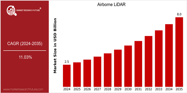
| 2024 | USD 2.53 Billion |
| 2035 | USD 8.0 Billion |
| CAGR (2025-2035) | 11.03 % |
Note – Market size depicts the revenue generated over the financial year
Airborne LiDAR market is expected to grow significantly, with a market size of $ 2,530.4 million in 2024, and an estimated $ 8,067 million in 2035. The CAGR for this period is 11.03%. The main reason for this growth is the increasing demand for high-resolution mapping and surveying solutions in various industries, such as forestry, agriculture, and urban planning. Also, the integration of LiDAR with artificial intelligence and machine learning is expected to improve the accuracy and efficiency of data collection and processing, thus driving the market. Leica Geosystems, Teledyne Technologies, and Quantum Spatial, which are the main players in the airborne LiDAR market, are continuously investing in R & D to improve their product offerings. Strategic initiatives, such as acquisitions, collaborations, and alliances, aimed at increasing service capabilities and geographical reach, are also shaping the market. The recent collaborations between the technology companies and government agencies for improving the monitoring of the environment and the monitoring of the state of the built environment, for example, have demonstrated the growing relevance of airborne LiDAR technology in solving modern challenges.
Regional Market Size
Regional Deep Dive
Airborne LiDAR Market is growing significantly in all regions, owing to advancements in technology and rising applications in forestry, agriculture and urban planning. In North America, the market is characterized by high adoption of airborne lidar technology, supported by a strong and developed infrastructure, and government initiatives for improving the monitoring of the environment and disaster management. Europe is characterized by a strong focus on sustainable agriculture, while Asia-Pacific is rapidly expanding, owing to urbanization and rapid development of the region's economy. Middle East and Africa are gradually adopting the technology, mainly in mining and oil exploration, while Latin America is beginning to explore the technology's potential in the environment and land surveying.
Europe
- The European Space Agency (ESA) has launched initiatives to incorporate LiDAR data into its Earth observation programs, emphasizing the importance of accurate topographical data for climate change studies.
- Innovations in mobile LiDAR systems by companies like Leica Geosystems are enabling more efficient data collection in urban environments, which is crucial for smart city planning and infrastructure management.
Asia Pacific
- China's rapid urbanization has led to increased investments in LiDAR technology for urban planning and infrastructure development, with companies like DJI and Beijing Sensing Technology making significant strides in the market.
- Australia's government is promoting the use of LiDAR for environmental monitoring and bushfire management, with projects like the National Vegetation Information System leveraging LiDAR data for better resource management.
Latin America
- Brazil is beginning to adopt LiDAR technology for environmental conservation efforts, particularly in monitoring deforestation in the Amazon rainforest, supported by government and NGO collaborations.
- Countries like Chile are exploring LiDAR for agricultural applications, with local startups developing solutions to enhance precision farming and crop management.
North America
- The U.S. Federal Aviation Administration (FAA) has recently updated regulations to facilitate the integration of drones equipped with LiDAR technology into national airspace, promoting innovation in aerial surveying and mapping.
- Companies like GeoCue and Quantum Spatial are leading the charge in developing advanced LiDAR systems tailored for specific applications, such as flood modeling and vegetation analysis, enhancing the market's growth potential.
Middle East And Africa
- The UAE is investing heavily in LiDAR technology for smart city initiatives, with projects like the Dubai Smart City project utilizing LiDAR for urban planning and infrastructure development.
- South Africa is seeing a rise in LiDAR applications in mining and resource management, with companies like Aerometrics leading the way in providing aerial survey services.
Did You Know?
“LiDAR technology can capture data at a rate of up to 1 million points per second, allowing for highly detailed 3D mapping of landscapes.” — National Oceanic and Atmospheric Administration (NOAA)
Segmental Market Size
Airborne LIDAR is an important segment of the market and is currently growing at a stable rate, driven by the rising demand for high-resolution mapping and surveying. The increasing need for accurate topographical data in industries such as forestry, agriculture and urban planning, as well as the increasing importance of government regulations for land use and land management, are also important growth drivers. Technological improvements to LIDAR systems, such as better sensors and data processing software, are also contributing to the growth of the market. At the moment, Airborne LIDAR is in the implementation stage, with companies such as Leica Geosystems and Quantum Spatial leading the way in the North American and European markets. The most important applications are vegetation analysis, flood modelling and the mapping of road and rail networks, such as the U.S. Geological Survey’s mapping programme. The macro-economic trends of sustainable development and government regulations requiring precise land use planning are driving growth. Drone technology and data analysis are also influencing the development of the market. Airborne LIDAR is becoming an indispensable tool for modern geospatial analysis.
Future Outlook
The airborne lidar market is expected to grow significantly between 2024 and 2035, with an estimated growth of $1,535 million to $8,000 million, a CAGR of 11.03%. The main growth driver is the increasing demand for high-resolution mapping and surveying in many industries, such as forestry, agriculture, urban planning and environmental protection. The airborne lidar technology is expected to be widely used in many industries, and the penetration rate of key industries will increase significantly, and the penetration rate will reach more than 30% in 2035 from about 10% in 2024. The key development of the technology, such as the integration of artificial intelligence and machine learning into the processing of lidar data, is expected to further improve the accuracy and efficiency of lidar data processing. Also, the government's support for sustainable development and environmental protection will also increase the investment in lidar. In addition, the trend of using drone-based lidar and the increasing focus on smart cities will also promote the market. The market is expected to be very competitive, and the trend of innovation and competition is imminent. The industry should be able to take advantage of these trends to achieve sustainable development.
Airborne LiDAR Market Highlights:
Leading companies partner with us for data-driven Insights
Kindly complete the form below to receive a free sample of this Report
Tailored for You
- Dedicated Research on any specifics segment or region.
- Focused Research on specific players in the market.
- Custom Report based only on your requirements.
- Flexibility to add or subtract any chapter in the study.
- Historic data from 2014 and forecasts outlook till 2040.
- Flexibility of providing data/insights in formats (PDF, PPT, Excel).
- Provide cross segmentation in applicable scenario/markets.