Certified Global Research Member


Key Questions Answered
- Global Market Outlook
- In-depth analysis of global and regional trends
- Analyze and identify the major players in the market, their market share, key developments, etc.
- To understand the capability of the major players based on products offered, financials, and strategies.
- Identify disrupting products, companies, and trends.
- To identify opportunities in the market.
- Analyze the key challenges in the market.
- Analyze the regional penetration of players, products, and services in the market.
- Comparison of major players’ financial performance.
- Evaluate strategies adopted by major players.
- Recommendations
Why Choose Market Research Future?
- Vigorous research methodologies for specific market.
- Knowledge partners across the globe
- Large network of partner consultants.
- Ever-increasing/ Escalating data base with quarterly monitoring of various markets
- Trusted by fortune 500 companies/startups/ universities/organizations
- Large database of 5000+ markets reports.
- Effective and prompt pre- and post-sales support.
Market Size Snapshot
| Year | Value |
|---|---|
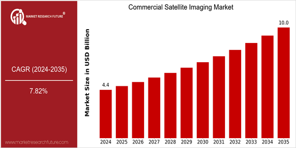
| 2024 | USD 4.37 Billion |
| 2035 | USD 10.0 Billion |
| CAGR (2025-2035) | 7.82 % |
Note – Market size depicts the revenue generated over the financial year
The commercial satellite-imaging market is expected to grow at a rapid rate. The current market is estimated to be worth $ 4.37 billion in 2024 and to reach $ 10 billion by 2035. CAGR, or compound annual growth rate, for this period is 7.82%. The main reason for this expansion is the rising demand for high-resolution images in a wide range of fields, including agriculture, urban planning, and defense. A second reason is that the development of small satellites and improved imaging technology will make satellite data more accessible and cheaper for more fields of application. The major players in the commercial satellite-imaging industry, such as Maxar, Planet, and Airbus, are constantly investing in new technology and strategic cooperation to strengthen their service offerings. In recent years, Maxar has taken several steps to improve its satellite constellation and data analysis capabilities. The commercial satellite-imaging market has also established a close relationship with governments and private companies, and has a positive impact on disaster prevention and the environment.
Regional Market Size
Regional Deep Dive
The commercial satellite photography market is undergoing a substantial change across various regions, driven by technological advancements, increasing demand for geospatial data, and the growing need for surveillance and monitoring applications. In North America, the market is characterized by the strong presence of key players and the government initiatives that support the use of satellite images for environmental monitoring, urban planning, and defense. In Europe, the demand for satellite images is growing mainly in agriculture and disaster management, driven by the regulations that encourage sustainable practices. The Asia-Pacific region is rapidly adopting the technology, driven by the investment in urbanization and the growing need for resource management. The Middle East and Africa are mainly using satellite images for resource management and security. Latin America is also emerging as a promising market, with a growing demand for agricultural and environmental applications.
Europe
- The European Space Agency (ESA) has launched initiatives like the Copernicus program, which provides free access to satellite data for environmental monitoring, significantly boosting the demand for commercial satellite imaging services.
- Regulatory changes in the EU, such as the Green Deal, are driving the adoption of satellite imagery for tracking environmental changes and supporting sustainable agricultural practices.
Asia Pacific
- Countries like India and China are investing heavily in satellite technology, with initiatives such as India's GIS-based satellite imaging program aimed at improving urban planning and disaster management.
- The rise of private companies in the region, such as EOS Data Analytics, is fostering innovation in satellite data analytics, enhancing the application of satellite imagery in various sectors.
Latin America
- Brazil is leveraging satellite imaging for deforestation monitoring in the Amazon, with government programs aimed at environmental protection and sustainable land use.
- The rise of startups in the region, such as Terra-i, is promoting the use of satellite data for agricultural monitoring and environmental conservation, indicating a growing interest in commercial satellite imaging.
North America
- The U.S. government has increased its investment in satellite imaging technologies, particularly through programs like the National Oceanic and Atmospheric Administration (NOAA), which aims to enhance weather forecasting and climate monitoring.
- Companies like Maxar Technologies and Planet Labs are innovating with high-resolution imaging capabilities, enabling applications in sectors such as agriculture, urban planning, and disaster response.
Middle East And Africa
- The UAE has launched the Mohammed bin Rashid Space Centre, which aims to develop satellite imaging capabilities for urban planning and environmental monitoring, showcasing the region's commitment to advancing satellite technology.
- In Africa, initiatives like the African Regional Data Cube are utilizing satellite imagery to support agricultural monitoring and land management, addressing food security challenges.
Did You Know?
“Did you know that satellite imagery can capture images with a resolution as fine as 30 centimeters, allowing for detailed analysis of urban environments and agricultural fields?” — Maxar Technologies
Segmental Market Size
The commercial satellite imagery market is undergoing strong growth, mainly due to the increasing demand for high-resolution images in various industries. The need for accurate data in agriculture, city planning and disaster management is growing rapidly, while satellite technology is advancing rapidly, which improves the quality of images and reduces the cost of satellite images. Government regulations have also increased the demand for land use planning and monitoring. The commercial satellite image market is now in a stage of expansion. Maxar and Planet are the leading companies in this field. The leading countries in this field are the United States and Europe, which use satellite images for precision agriculture and road monitoring. The main applications are in the fields of agriculture, defense and intelligence, and resource management. , the frequency of natural disasters is increasing, and the trend of sustainable development has become more and more important. Artificial intelligence and machine learning are the driving forces for the development of the satellite image industry, and they are expected to bring more accurate and timely data analysis and insights, which will help various industries to make better decisions.
Future Outlook
The International Space Agency (IA) and the American Space Agency (Astlas) are to develop the system of a worldwide network of observation stations. This growth is supported by the increasing demand for various purposes such as agriculture, city planning, and the supervision of the environment. The penetration of the satellite images in the decision-making process of the companies is expected to increase considerably in the future, and the penetration rate of the satellite images in the key industries may reach up to 30 percent in 2035. The development of the high-resolution observation and the real-time data processing are expected to increase the growth of the market. The integration of artificial intelligence and machine learning into the analysis of the satellite images will increase the accuracy and value of the data collected and make it more available and usable for the end users. Moreover, the favorable government policies and the investments in the space infrastructure will create a favorable environment for the growth of the market. The increasing focus on the observation of the climate change will also accelerate the adoption of the commercial satellite images, thereby preparing the market for a very promising future.
Covered Aspects:| Report Attribute/Metric | Details |
|---|---|
| Market Size Value In 2022 | USD 2.6 Billion |
| Market Size Value In 2023 | USD 2.80 Billion |
| Growth Rate | 7.80% (2023-2032) |
Commercial Satellite Imaging Market Highlights:
Leading companies partner with us for data-driven Insights
Kindly complete the form below to receive a free sample of this Report
Tailored for You
- Dedicated Research on any specifics segment or region.
- Focused Research on specific players in the market.
- Custom Report based only on your requirements.
- Flexibility to add or subtract any chapter in the study.
- Historic data from 2014 and forecasts outlook till 2040.
- Flexibility of providing data/insights in formats (PDF, PPT, Excel).
- Provide cross segmentation in applicable scenario/markets.