Commercial Satellite Imaging Market Summary
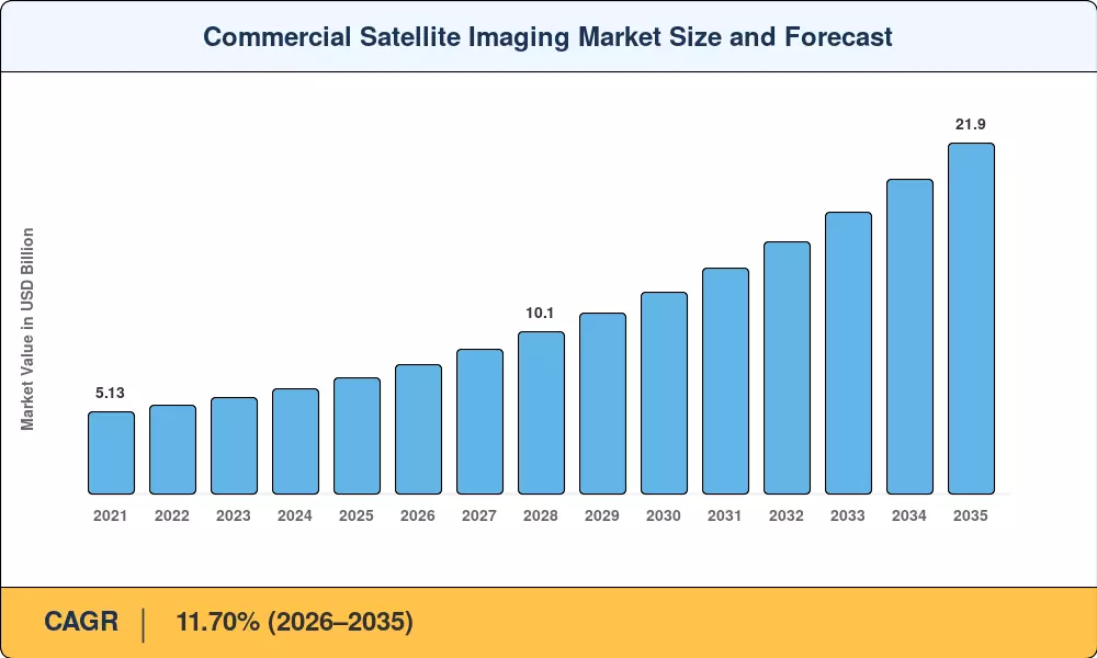
The Commercial Satellite Imaging Market was valued at USD 7.24 billion in 2025 and is projected to reach USD 8.09 billion in 2026 before climbing to USD 21.90 billion by 2035, registering an 11.70% CAGR across the 2026–2035 forecast window. Mandatory methane-verification obligations under the European Union Methane Regulation — effective across North Sea and Mediterranean upstream operators — have converted what was once voluntary emissions monitoring into a recurring procurement line item, pulling compliance-driven budgets toward satellite-based sensing. Parallel momentum comes from national defense agencies accelerating persistent-surveillance contracts tied to Arctic and Indo-Pacific theater requirements [1][2].
The Commercial Satellite Imaging Market is at a technical inflection point at the constellation level. Legacy single-satellite systems are being displaced by nimble microconstellations carrying synthetic-aperture-radar payloads that provide sub-daily revisit rates that are independent of cloud cover or daylight conditions. Since 2021, venture-supported operators have raised over USD 4.8 billion in cumulative private finance, enabling quick build-out cycles that condense revisit intervals from days to hours [3]. AI-powered tip-and-cue tasking engines now independently schedule collection passes, reducing order-to-delivery time from 48 hours to less than three.
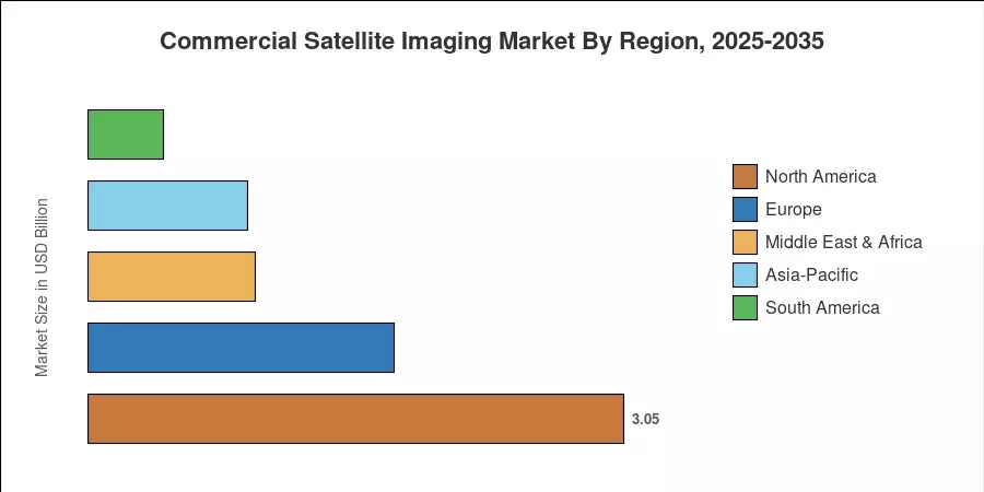
North America accounts for some 42.1% of global revenues, powered by U.S. defense and intelligence purchasing, and a robust commercial analytics ecosystem. Asia-Pacific is the fastest-growing market with an estimated CAGR of 12.60%, driven by smart-city digitization in India, China and Southeast Asia. The second greatest part of about 24.0% goes to Europe, where increases in the Copernicus program and new ESA Earth-observation tenders can be noted [4]. Analytics subscriptions replacing one-off picture orders are driving the Commercial Satellite Imaging Market towards platform economics for recurring-revenue operators.
Key Report Takeaways
• By Application
- Geospatial data acquisition and mapping accounted for approximately 22.5% of 2025 revenue, reflecting demand from cadastral surveys, urban planning, and infrastructure monitoring programs.
- Defense and intelligence applications are forecast to expand at a 14.1% CAGR through 2035, the fastest rate among application segments, driven by persistent ISR mandates.
- Natural resource management is gaining traction as carbon-credit registries and mining operators integrate change-detection analytics into compliance workflows.
• By Imaging Type
- Optical multispectral and panchromatic systems captured roughly 48.3% of 2025 demand within the Commercial Satellite Imaging Market, benefiting from mature processing pipelines and broad end-user familiarity.
- Radar/SAR platforms are projected to grow at a 12.6% CAGR, reflecting all-weather, day-night imaging advantages that optical alternatives cannot match.
• By Geography
- North America led the Commercial Satellite Imaging Market with a 42.1% revenue share in 2025, underpinned by NGA and NRO contract vehicles.
- Asia-Pacific is anticipated to register a 12.60% CAGR to 2035, supported by India's Geospatial Policy liberalization and China's commercial remote-sensing licensing reforms.
Market Size and Forecast (2021–2035)
Market Research Future’s sizing methodology triangulates bottom-up revenue estimates from operator filings, government procurement databases, and downstream analytics subscriptions, with top-down demand modeling calibrated against orbital capacity growth and spectral-band pricing benchmarks.