info@marketresearchfuture.com   📞  +1 (855) 661-4441(US)   📞  +44 1720 412 167(UK)
Certified Global Research Member
Isomar fd.webp Wcrc 57.webp
Key Questions Answered
  • Global Market Outlook
  • In-depth analysis of global and regional trends
  • Analyze and identify the major players in the market, their market share, key developments, etc.
  • To understand the capability of the major players based on products offered, financials, and strategies.
  • Identify disrupting products, companies, and trends.
  • To identify opportunities in the market.
  • Analyze the key challenges in the market.
  • Analyze the regional penetration of players, products, and services in the market.
  • Comparison of major players’ financial performance.
  • Evaluate strategies adopted by major players.
  • Recommendations
Why Choose Market Research Future?
  • Vigorous research methodologies for specific market.
  • Knowledge partners across the globe
  • Large network of partner consultants.
  • Ever-increasing/ Escalating data base with quarterly monitoring of various markets
  • Trusted by fortune 500 companies/startups/ universities/organizations
  • Large database of 5000+ markets reports.
  • Effective and prompt pre- and post-sales support.

Mobile Mapping Market Share

ID: MRFR//4292-CR | 186 Pages | Author: Aarti Dhapte| November 2020

The mobile mapping market is shaped by several key factors that drive its growth and evolution. One significant factor is the increasing demand for location-based services and applications across various industries. With the widespread adoption of smartphones and connected devices, consumers and businesses alike rely on mobile mapping technologies to access real-time location data, navigation services, and location-based information such as nearby businesses, points of interest, and traffic conditions. This growing demand for mobile mapping solutions fuels innovation and drives investment in technologies such as GPS, LiDAR, and augmented reality (AR) to enhance the accuracy, coverage, and usability of mobile mapping applications.


Technological advancements also play a crucial role in shaping the mobile mapping market. The convergence of mobile computing, sensor technologies, and geospatial analytics has led to the development of advanced mobile mapping platforms capable of capturing, processing, and analyzing geospatial data in real-time. Mobile mapping solutions leverage a combination of GPS, inertial navigation systems (INS), and advanced sensors such as LiDAR, cameras, and radar to collect high-resolution 3D imagery and generate detailed maps of the surrounding environment. Additionally, the integration of machine learning (ML) and artificial intelligence (AI) enables automated feature extraction, object recognition, and semantic segmentation, enhancing the accuracy and efficiency of mobile mapping workflows.


Another market factor driving the growth of the mobile mapping market is the increasing adoption of autonomous vehicles and smart transportation systems. Mobile mapping technologies play a crucial role in enabling autonomous vehicles to navigate safely and efficiently by providing accurate localization and mapping capabilities. Mobile mapping solutions are used to create high-definition maps of roadways, infrastructure, and traffic conditions, enabling autonomous vehicles to perceive and understand their surroundings in real-time. Additionally, mobile mapping data is utilized to optimize route planning, traffic management, and infrastructure maintenance, leading to safer and more efficient transportation systems.


Furthermore, the proliferation of mobile mapping applications in industries such as construction, agriculture, utilities, and logistics contributes to market growth. Mobile mapping solutions are used to survey and map construction sites, monitor crop health, manage utility networks, and optimize logistics operations. By providing accurate geospatial data and real-time insights, mobile mapping technologies enable businesses to improve productivity, reduce costs, and make informed decisions. Additionally, the integration of mobile mapping with other technologies such as drones, robotics, and IoT sensors expands the capabilities and applications of mobile mapping solutions across various industries.


Market competition also drives innovation and evolution in the mobile mapping market. With the emergence of new players and startups offering innovative mobile mapping solutions, competition intensifies, prompting vendors to differentiate themselves through advanced features, usability, and integration capabilities. Additionally, strategic partnerships and collaborations between mobile mapping vendors, technology providers, and industry stakeholders enable interoperability and facilitate the development of integrated solutions tailored to specific use cases and industry verticals.


Moreover, regulatory initiatives and government investments in infrastructure modernization and smart city development drive the adoption of mobile mapping solutions. Governments and regulatory bodies worldwide recognize the importance of accurate geospatial data and mapping technologies for urban planning, disaster management, and environmental monitoring. Mobile mapping solutions are utilized to create digital twins of cities, monitor infrastructure assets, and analyze spatial data to improve urban mobility, public safety, and environmental sustainability. Additionally, government funding and incentives for research and development initiatives in mobile mapping technologies stimulate innovation and fuel market growth.


Economic factors such as cost-effectiveness and return on investment (ROI) also influence the adoption of mobile mapping solutions. Organizations seek cost-effective solutions that offer tangible benefits such as increased productivity, improved decision-making, and competitive advantage. Cloud-based mobile mapping platforms, offered on a subscription or pay-as-you-go basis, provide scalability, flexibility, and cost savings compared to traditional on-premises solutions. Additionally, vendors offering value-added services such as data analytics, visualization, and consulting gain a competitive edge in the market.

Covered Aspects:

Report Attribute/Metric Details
Base Year For Estimation 2022
Historical Data 2018- 2022
Forecast Period 2023-2032
Growth Rate 12.30% (2023-2032)

Mobile Mapping Market Overview


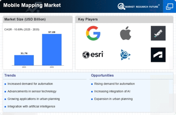
The Mobile Mapping Market is projected to grow from USD 31.76 Billion in 2024 to USD 71.58 billion by 2032, exhibiting a compound annual growth rate (CAGR) of 10.69% during the forecast period (2024 - 2032). Additionally, the market size for Mobile Mapping was valued at USD 28.29 billion in 2023.


Increased health concerns and challenges have led to more expensive operations and more bariatric procedures are the key market drivers enhancing the market growth.


Figure 1: Mobile Mapping Market Size, 2024-2032 (USD Billion)


Mobile Mapping Market Overview2


Source: Secondary Research, Primary Research, MRFR Database and Analyst Review


Mobile Mapping Market Trends


Growing use of AI is driving the market growth

Market CAGR for mobile mapping is being driven by the rising use of Artificial Intelligence (AI). The navigation systems now utilized internationally are projected to change when augmented reality and mobile mapping technologies are integrated. The increased use of smartphones has given augmented reality technologies new areas of use. Users may examine information about an area in front of their mobile devices thanks to integrating data obtained through mobile mapping systems with augmented reality, letting them access the location specifics, like the street's name and other essential information. 


Integrating geographical data obtained by mobile devices with this technology is being used to apply mobile augmented reality to navigation systems. Users of mobile AR navigation systems may view virtual worlds on their devices while navigating. These solutions give users more information about the items in their immediate surroundings, such as structures, telephone or electric poles, trees, signs, landmarks, and roadside furniture. Using information obtained from mobile mapping systems, AR also provides details such as measurements, sizes, and properties of the object existing in the users' surroundings.


Additionally, augmented reality solutions may be applied to developing location intelligence, introducing high-resolution maps for autonomous vehicles, and producing live maps that alter themselves in response to changing environmental circumstances. Using mobile-mapped geographical data, augmented reality may also be used to construct exact 3D maps of locations and surroundings. Shortly, it is anticipated that developments in augmented reality and its integration with data produced by mobile mapping systems will change mapping and navigation systems. Mobile mapping technology has undergone a full transformation due to recent advancements in UAV technology and steep price declines for these vehicles.


The primary uses of mobile mapping systems using UAVs are environmental detection and disaster monitoring. UAVs are the best option for data gathering in disaster-affected areas since they provide quick spatial information-collecting capabilities at a far lower cost than manned aerial mapping methods. In urban planning, 3D building modeling, archaeological documentation, pipeline inspection, environmental monitoring, infrastructure inventory and monitoring, landslide hazard assessment, open-pit mining, and indoor mapping, UAV-based modeling offers sizable advantages over conventional mapping techniques. The price of UAV mobile mapping systems has also decreased thanks to technological advancements, including low-cost, high-resolution digital cameras, laser scanners, and navigation systems. Thus, driving the Mobile Mapping market revenue.


Mobile Mapping Market Segment Insights


Mobile Mapping Component Insights


The Mobile Mapping market segmentation, based on type, includes hardware, software and services. The hardware segment dominated the market, accounting for 45% of market revenue. Hardware elements installed on an aerial vehicle or a car are used to construct mobile mapping systems. On helicopters and backpacks, modern mobile mapping systems may also be attached. These hardware elements gather precise geographical data for various applications, including highway surveys, city modeling, and utility, environmental, and mapping projects.


Mobile Mapping Solution Insights


The Mobile Mapping market segmentation based on solutions includes location-based, indoor, asset management and 3D mapping. The location-based segment dominated the market. The location-based services include monitoring, tracking, navigation, and surveillance for mobile assets, including transport trucks and individual cars. It benefits the corporate and consumer industries by offering convenience, direction, security, and entertainment. If location-based services are integrated, mobile phones may utilize network-based technologies or inbuilt satellite receivers. Numerous industrial sectors employ location-based services, including government, transportation, healthcare, and education.


Mobile Mapping Application Insights


The Mobile Mapping market segmentation based on application includes land survey and aerial survey. The land surveys segment dominated the market. When doing a land survey, information is obtained using mobile mapping equipment, and it is then analyzed to identify the relative locations of existing points on the earth's surface. Certain agencies conduct surveys using various mapping tools and methods to find property lines, roads, buildings, watercourses, easements, and other ground features. Inertial navigation, cameras, GPS, and high-resolution lidar are all utilized in land surveying.


Mobile Mapping End User Insights


Based on End Users, the Mobile Mapping market segmentation includes real estate & construction, IT & telecom and others. The real estate & construction category generated the most income. Geospatial technologies are linked with tools like building information modeling (BIM) and virtual design and construction (VDC) to acquire and analyze infrastructure-related data for planning, constructing, maintaining, and renovating purposes. Airborne devices are fitted with lidar scanners to give customers a thorough and precise three-dimensional mapping of the targeted regions, such as lands and buildings.


Figure 2: Mobile Mapping Market, by End User, 2022 & 2032 (USD Billion)


Mobile Mapping Market, by End User


Source: Secondary Research, Primary Research, MRFR Database and Analyst Review


Mobile Mapping Regional Insights


By region, the study provides market insights into North America, Europe, Asia-Pacific and the Rest of the World. The North American Mobile Mapping market will dominate; the expansion in this area is also driven by the rising use of smartphones with Positioning Systems (GPS) in the US, Mexico, and Canada. Rapid developments in 3D mobile mapping software, image processing, and data processing in the North American area also contribute to expanding the regional market.


Further, the major countries studied in the market report are The US, Canada, German, France, Spain, China, Japan, India, Australia, UK, Italy, South Korea, and Brazil.


Figure 3: MOBILE MAPPING MARKET SHARE BY REGION 2022 (USD Billion)


MOBILE MAPPING MARKET SHARE BY REGION


Source: Secondary Research, Primary Research, MRFR Database and Analyst Review


Europe has the second-largest market share for Mobile Mapping. The market expansion in the European area has been helped by using mobile mapping technology for various applications, including automated detection of traffic signals, road signs, pedestrian trails, and asset monitoring and management. Furthermore, the German Mobile Mapping market dominated, while the UK Mobile Mapping market grew fastest in Europe.


From 2023 to 2032, the Asia-Pacific Mobile Mapping Market will develop at the quickest CAGR. Mobile mapping technology has seen strong demand in the Asia-Pacific region for use in smart highway systems, transportation systems, and land vehicle navigation. Additionally, the number of mobile mapping applications for location-based services has rapidly increased across the Asia-Pacific region. Furthermore, China's Mobile Mapping market had the highest market share, while India's Mobile Mapping market was the fastest expanding in the Asia-Pacific region.


Mobile Mapping Key Market Players & Competitive Insights


Leading market companies are extensively spending R&D on increasing their product lines, which will help the Mobile Mapping market grow even more. Important market developments include new product releases, contractual agreements, acquisitions and mergers, greater investments, and collaboration with other organizations. The Mobile Mapping industry must produce cost-effective merchandise to flourish and thrive in a more competitive and increasing market climate.


Manufacturing locally to reduce operating costs is an effective business strategy manufacturers use in the worldwide Mobile Mapping industry to serve clients and expand the market sector. The Mobile Mapping industry has provided some of the most important benefits recently. Major players in the Mobile Mapping market, including Leica Geosystems, Drivewyze Inc and others, are attempting to increase market demand by investing in research and development operations.


Leica Geosystems, which is situated in eastern Switzerland, produces products and systems for surveying and geographic measurement (geomatics). With the help of its products, users may represent existing buildings and terrains in computer-based systems with great accuracy—often under 1 cm. These technologies include GPS satellite navigation and laser rangefinders. In May 2022, Leica Geosystems introduced the Leica Pegasus TRK to its lineup of mobile mapping equipment. The Leica Pegasus TRK product uses dynamic laser scanning technology to quickly and accurately capture, measure, and visualize objects.


The pioneer in connected truck services, Drivewyze Inc., is redefining efficiency and safety in transportation. With cutting-edge trucking services like Drivewyze PreClear shortcut, Drivewyze Safety Notifications, the Drivewyze Weigh Station Activity Report, and Drivewyze Insights, they support commercial drivers and fleets. Drivewyze services are provided via smartphones and tablets and built right into the ELDs and in-cab gadgets that carriers choose, like Omnitracs, PeopleNet, Transflo, Geotab, and others. In September 2022, In partnership with INRIX, a supplier of transportation analytics and connected car services, and the Pennsylvania Turnpike Commission, Drivewyze introduced real-time, in-cab traffic alerts.


Key Companies in the Mobile Mapping market include


  • Trimble Inc

  • Google

  • Mitsubishi Electric Corporation

  • Pasco Corporation

  • The Sanborn Map Company Inc.

  • Huron Geomatics Inc

  • Topcon Corporation

  • 3D Laser Mapping

  • Apple Inc.

  • NavVis

  • Telefonaktiebolaget LM Ericsson

  • NGC Aerospace Ltd,

  • FARCO Technologies Inc

  • Microsoft Corporation

  • Hexagon AB

  • TomTom International BV

  • IGI GmbH


Mobile Mapping Industry Developments


In June 2023, TOPCON CORPORATION announced acquiring SATEL, a wireless technology company based in Finland. The Company is involved in the design and manufacture of products such as connectivity solutions that enable mission critical connections. The move was aimed to assist TOPCON CORPORATION utilize advanced communication technology provided by SATEL for strengthening high accurate positioning solutions.


Stonex launched a hybrid mobile mapping solution called X70GO SLAM laser scanner designed for fast and efficient large area surveys in February 2024. Stationary scanning combines mobile scanning with stationary mode scanning at very high resolutions, thus improving general surveying capabilities. It is a real-time 3D model reconstruction device comprising an inertial navigation module, high-performance computer and storage system, which are integrated into the Trimble MX90 vehicle-mounted MX90, capturing detailed laser scans and imagery panoramic or multi-angle.


Mosaic, in 2024, recently, partnered with Movella to redefine precision & efficiency in mapping & 3D reconstruction projects. Mosaic specializes in mobile mapping camera systems, while Movella provides valuable inertial sensor solutions tailored to high-precision requirements. The integration between Mosaic's Mosaic 51 and Mosaic X camera systems with Movella's XVN enhances GIS platform integration, allowing extensive 3D reconstruction with unmatched precision. This collaboration between the two companies combines Mosaic’s Mobile Mapping Systems’ range of Mosaic cameras, including extensive models of XVN from Movella, most importantly for the purpose of GIS platform integration and extensive 3D reconstruction with unmatched accuracy.


Trimble announced the release of the MX90 mobile mapping system for construction projects in February 2024. When combined with Trimble field and office software, the Trimble GNSS and inertial technology power a field-to-finish mobile mapping solution that enables workflows for data capture, processing and analysis. The vehicle-mounted or train-mounted MX90 captures detailed laser scans and imagery-both panoramic and multi-angle.


Teledyne Geospatial launched Galaxy Onboard, an airborne survey solution, in February 2023. The Company is launching Galaxy Onboard for real-time Airborne LiDAR applications. Customers were also targeted by the Company through this announcement as it hopes to help them automate manual work thereby reducing information processing time.


Mobile Mapping Market Segmentation


Mobile Mapping Component Outlook


  • Hardware


  • Software


  • Services


Mobile Mapping Solution Outlook


  • Location-Based


  • Indoor Mapping


  • Asset Management


  • 3D Mapping


Mobile Mapping Application Outlook


  • Land Surveys


  • Aerial Surveys


Mobile Mapping End-User Outlook


  • Real Estate & Construction


  • IT & Telecom


  • Others


Mobile Mapping Regional Outlook


  • North America


    • US


    • Canada


  • Europe


    • Germany


    • France


    • UK


    • Italy


    • Spain


    • Rest of Europe


  • Asia-Pacific


    • China


    • Japan


    • India


    • Australia


    • South Korea


    • Australia


    • Rest of Asia-Pacific


  • Rest of the World


    • Middle East


    • Africa


    • Latin America


Leading companies partner with us for data-driven Insights
client_1 client_2 client_3 client_4 client_5 client_6 client_7 client_8 client_9 client_10
Kindly complete the form below to receive a free sample of this Report
Please fill in Business Email for Quick Response

We do not share your information with anyone. However, we may send you emails based on your report interest from time to time. You may contact us at any time to opt-out.

Purchase Option
Single User $ 4,950
Multiuser License $ 5,950
Enterprise User $ 7,250
Compare Licenses
Tailored for You
  • Dedicated Research on any specifics segment or region.
  • Focused Research on specific players in the market.
  • Custom Report based only on your requirements.
  • Flexibility to add or subtract any chapter in the study.
  • Historic data from 2014 and forecasts outlook till 2040.
  • Flexibility of providing data/insights in formats (PDF, PPT, Excel).
  • Provide cross segmentation in applicable scenario/markets.