Growing Demand for Precision Mapping
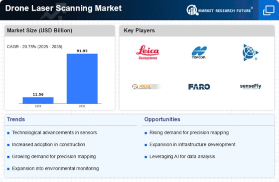
The Drone Laser Scanning Market experiences a notable surge in demand for precision mapping solutions across various sectors. Industries such as construction, mining, and agriculture increasingly rely on accurate topographical data to enhance project planning and execution. The ability of drone laser scanning technology to capture high-resolution 3D models facilitates improved decision-making processes. Recent data indicates that the market for precision mapping is projected to grow at a compound annual growth rate of approximately 15% over the next five years. This growth is driven by the need for detailed spatial information, which is essential for effective resource management and operational efficiency.
Enhanced Data Collection Capabilities
The Drone Laser Scanning Market benefits from enhanced data collection capabilities offered by advanced drone technologies. Modern drones equipped with high-precision laser scanners can capture vast amounts of data in a fraction of the time required by traditional methods. This efficiency is particularly advantageous in industries such as construction and environmental assessment, where timely data is crucial. Market analysis reveals that the efficiency gains from using drone laser scanning can reduce project timelines by up to 40%, making it an attractive option for businesses seeking to optimize their operations and reduce costs.
Regulatory Support for Drone Operations
Regulatory frameworks supporting drone operations are emerging as a critical driver in the Drone Laser Scanning Market. Governments worldwide are establishing guidelines that facilitate the safe and efficient use of drones for commercial purposes. This regulatory support not only enhances public safety but also encourages investment in drone technologies. As a result, the market is witnessing an influx of new players and innovations. Recent statistics indicate that the number of approved drone operations has increased by over 30% in the past year, reflecting a growing acceptance of drone technology in various sectors, including surveying and mapping.
Rising Interest in Smart City Initiatives
The increasing focus on smart city initiatives is driving growth in the Drone Laser Scanning Market. As urban areas strive to become more efficient and sustainable, the demand for accurate data to inform infrastructure development and urban planning rises. Drone laser scanning provides essential data for creating detailed 3D models of urban environments, which can be utilized for various applications, including traffic management and utility planning. Market projections indicate that investments in smart city technologies are expected to reach several billion dollars in the coming years, positioning drone laser scanning as a vital tool in the realization of these initiatives.
Integration with Geographic Information Systems (GIS)
The integration of drone laser scanning technology with Geographic Information Systems (GIS) is a pivotal driver in the Drone Laser Scanning Market. This synergy allows for the seamless incorporation of laser-scanned data into GIS platforms, enhancing the analytical capabilities of spatial data. As organizations increasingly adopt GIS for urban planning, environmental monitoring, and asset management, the demand for drone laser scanning services rises correspondingly. The market data suggests that the GIS sector is expected to expand significantly, with drone laser scanning playing a crucial role in providing accurate and timely data for various applications, thereby fostering informed decision-making.

