Expansion of Drone Technology
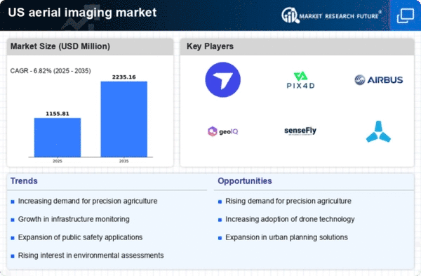
The rapid expansion of drone technology significantly impacts the aerial imaging market. Drones equipped with high-resolution cameras and sensors are increasingly utilized for capturing aerial imagery in a cost-effective manner. The market for commercial drones is expected to reach $43 billion by 2024, indicating a robust growth trajectory. This expansion allows for more accessible aerial imaging solutions for small and medium-sized enterprises, which previously relied on traditional methods. As drone technology continues to evolve, the aerial imaging market is likely to benefit from enhanced capabilities, such as improved flight times and data collection efficiency.
Increased Demand for Aerial Data
The aerial imaging market experiences heightened demand for aerial data across various sectors, including agriculture, construction, and real estate. This demand is driven by the need for precise mapping, monitoring, and analysis. For instance, the agricultural sector utilizes aerial imaging for crop health assessment and yield prediction, which can enhance productivity by up to 20%. In construction, aerial imaging aids in project planning and progress tracking, reducing costs by approximately 15%. As industries increasingly recognize the value of aerial data, the aerial imaging market is projected to grow significantly, with an expected CAGR of around 12% over the next five years.
Growing Interest in Urban Planning
Urban planning is becoming increasingly reliant on aerial imaging to facilitate effective city development and management. Planners utilize aerial imagery for land use analysis, infrastructure development, and environmental assessments. The aerial imaging market supports these activities by providing detailed visual data that informs decision-making. As urban populations continue to rise, the demand for efficient urban planning solutions is expected to grow. This trend suggests that the aerial imaging market will play a crucial role in shaping sustainable cities, with an anticipated increase in market size driven by urban development projects.
Integration of AI and Machine Learning
The integration of artificial intelligence (AI) and machine learning technologies into the aerial imaging market is transforming data analysis and interpretation. These technologies enable the automation of image processing, enhancing the accuracy and speed of data extraction. For example, AI algorithms can identify patterns and anomalies in aerial images, which is particularly beneficial in sectors like environmental monitoring and urban planning. The potential for AI to improve decision-making processes is substantial, as it can reduce analysis time by up to 30%. Consequently, the aerial imaging market is likely to see increased investment in AI-driven solutions, further propelling its growth.
Enhanced Public Safety and Security Applications
The aerial imaging market is witnessing a surge in applications related to public safety and security. Law enforcement agencies and emergency responders increasingly utilize aerial imagery for surveillance, disaster response, and crime scene analysis. The ability to obtain real-time aerial data can significantly enhance situational awareness and response times. For instance, aerial imaging can assist in locating missing persons or assessing damage after natural disasters. As public safety concerns continue to rise, the aerial imaging market is likely to expand, with investments in advanced imaging technologies that support these critical applications.


