Aerial Survey Service Market Overview
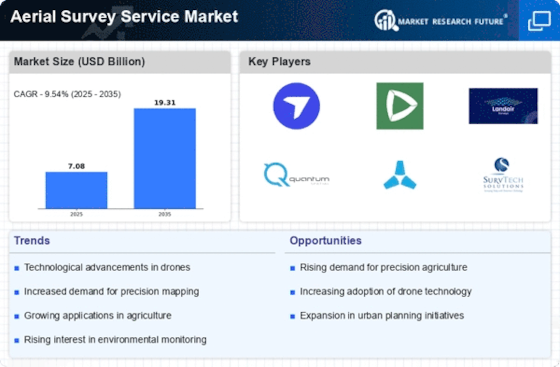
As per MRFR analysis, the Aerial Survey Service Market Size was estimated at 5.39 (USD Billion) in 2022. The Aerial Survey Service Market Industry is expected to grow from 5.9(USD Billion) in 2023 to 13.4 (USD Billion) by 2032. The Aerial Survey Service Market CAGR (growth rate) is expected to be around 9.54% during the forecast period (2024 - 2032).
Key Aerial Survey Service Market Trends Highlighted
Key Market Drivers:
Technological advancements in imaging and data processing, such as the use of drones, LiDAR, and AI, are driving growth in the aerial survey service market. Increased demand for accurate and timely data for various applications, including infrastructure planning, natural resource management, and disaster response, fuels market expansion.
Opportunities to Explore and Capture:
Emerging technologies like hyperspectral imaging and 3D mapping offer potential for new market segments and application areas. Integration with GIS systems and other data sources enhances the value of aerial survey data, creating opportunities for collaboration and partnerships. The growing adoption of aerial surveys for environmental monitoring, precision agriculture, and asset inspections presents untapped growth potential.
Recent Trends:
The increasing adoption of cloud-based platforms for data storage and processing has simplified access to aerial survey data, fostering growth. The use of artificial intelligence (AI) and machine learning (ML) for data analysis and interpretation is transforming the market, enabling faster and more accurate results. The rise of subscription-based pricing models is providing flexibility and cost-effectiveness for customers. The growing emphasis on sustainability and environmental conservation is driving demand for aerial surveys for environmental monitoring and assessment.
Source: Primary Research, Secondary Research, MRFR Database and Analyst Review
Aerial Survey Service Market Drivers
-
Rapid Technological Advancements
The Global Aerial Survey Service Market Industry is experiencing rapid technological advancements, with the integration of various technologies such as drones, photogrammetry, and remote sensing. These advancements enable the collection of more accurate, detailed, and real-time data, leading to improved decision-making and planning processes. The use of drones, in particular, has gained significant traction due to their ability to access remote and challenging terrains, providing high-resolution imagery and data.Furthermore, the integration of AI and machine learning algorithms into aerial survey services automates data analysis and interpretation tasks, enhancing efficiency and reducing the time required to deliver valuable insights.
Growing Demand for Infrastructure Development
The increasing demand for infrastructure development projects around the world is a key driver of the Global Aerial Survey Service Market Industry. Aerial surveys play a crucial role in planning and monitoring infrastructure projects, such as roads, bridges, railways, and pipelines. These surveys provide detailed information about topography, land use, and environmental factors, enabling engineers and planners to design and construct infrastructure that is safe, efficient, and environmentally sustainable.The use of aerial surveys helps optimize project timelines, reduce costs, and minimize potential risks associated with infrastructure development.
Environmental Monitoring and Disaster Management
Aerial surveys are extensively used for environmental monitoring and disaster management applications. They provide valuable data for assessing natural resources, monitoring deforestation, and tracking the impact of human activities on the environment. In the event of natural disasters, such as hurricanes, earthquakes, and floods, aerial surveys provide timely and accurate information for damage assessment, relief efforts, and recovery planning. The ability of aerial surveys to cover large areas quickly and efficiently makes them an indispensable tool for environmental protection and disaster response.
Aerial Survey Service Market Segment Insights
-
Aerial Survey Service Market Platform Insights
The Global Aerial Survey Service Market is segmented by Platform into Fixed-Wing Aircraft, Helicopters, Drones, and Satellites. Fixed-Wing Aircraft accounted for the largest share of the market in 2023, and is expected to continue to dominate the market throughout the forecast period. Fixed-wing aircraft offer a number of advantages over other platforms, including their ability to cover large areas quickly and efficiently, their high payload capacity, and their ability to operate in a variety of weather conditions. Helicopters are expected to be the fastest-growing segment of the market over the forecast period.
Helicopters offer a number of advantages over fixed-wing aircraft, including their ability to hover, their maneuverability, and their ability to operate in confined spaces. Drones are expected to be a major growth driver for the market over the forecast period. Drones are becoming increasingly affordable and easy to use, and they offer a number of advantages over traditional aerial survey methods, including their ability to access hard-to-reach areas, their low operating costs, and their ability to collect high-resolution data. Satellites are expected to play an increasingly important role in the market over the forecast period.
The growth of the market is being driven by a number of factors, including the increasing demand for aerial survey data, the declining cost of aerial survey services, and the increasing adoption of new technologies.
Source: Primary Research, Secondary Research, MRFR Database and Analyst Review
Aerial Survey Service Market Technology Insights
Aerial Photography, LiDAR, Hyperspectral Imaging, Radar, and Multispectral Imaging are the key technologies utilized in the aerial survey service market. Aerial Photography, a traditional method, captures high-resolution images of the Earth's surface, providing detailed visual data. LiDAR (Light Detection and Ranging) generates precise 3D models of terrain and structures by emitting laser pulses and measuring their return time. Hyperspectral Imaging analyzes the spectral properties of objects, enabling the identification and mapping of minerals, vegetation, and other materials.
Radar (Radio Detection and Ranging) penetrates through clouds and darkness, providing all-weather imaging capabilities. Multispectral Imaging captures images across multiple wavelengths, enhancing the detection and classification of different features.
Aerial Survey Service Market Application Insights
Land Surveying and Mapping held the largest revenue share in the Global Aerial Survey Service Market in 2023, owing to the increasing demand for accurate and detailed maps for various applications such as urban planning, land use planning, and infrastructure development. Natural Resource Management is projected to witness a higher CAGR during the forecast period, driven by the growing need for effective management of natural resources, including forests, water bodies, and mineral deposits. Environmental Monitoring is also expected to witness significant growth, as aerial surveys play a crucial role in monitoring environmental health, detecting pollution, and assessing the impact of climate change.
Disaster Response applications are anticipated to have a notable presence in the market, as aerial surveys are used to assess damage, support relief efforts, and monitor recovery progress after natural disasters. Infrastructure Inspection is another important application segment, utilizing aerial surveys to assess the condition of bridges, roads, buildings, and other infrastructure assets for maintenance and repair purposes.
Aerial Survey Service Market End-User Insights
The Global Aerial Survey Service Market is segmented by End-User into Government Agencies, Private Sector Companies, Research Institutions, and Non-profit Organizations. Government Agencies are expected to hold the largest market share in the Global Aerial Survey Service Market in 2023, owing to the increasing demand for aerial surveys for land use planning, infrastructure development, and environmental monitoring. Private Sector Companies are expected to be the fastest-growing segment in the market, due to the rising adoption of aerial surveys for construction, mining, and agriculture.
Research Institutions are also expected to contribute significantly to the market growth, as they increasingly use aerial surveys for scientific research and data collection. Non-profit Organizations are expected to have a moderate share in the market, as they use aerial surveys for humanitarian aid, disaster relief, and environmental conservation.
Aerial Survey Service Market Regional Insights
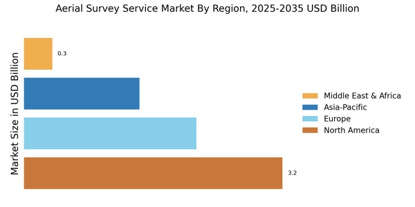
The regional segment of the Global Aerial Survey Service Market offers valuable insights into the market's geographic distribution and growth potential. North America accounted for a significant share of the market in 2023, owing to the presence of major players, advanced technology adoption, and increasing investments in infrastructure development. Europe is another key region, driven by growing demand for aerial surveys in sectors such as construction, agriculture, and environmental monitoring. APAC is projected to witness substantial growth over the forecast period, fueled by rapid urbanization, infrastructure expansion, and rising environmental concerns.
South America and MEA are emerging markets with untapped potential, presenting opportunities for market expansion. The Global Aerial Survey Service Market revenue is expected to reach approximately 13.4 billion USD by 2032, exhibiting a CAGR of 9.54% during the forecast period.
Source: Primary Research, Secondary Research, MRFR Database and Analyst Review
Aerial Survey Service Market Key Players And Competitive Insights
Major players in Aerial Survey Service Market industry are constantly striving to enhance their technological capabilities and expand their service offerings to cater to the evolving needs of various end-use industries. Leading Aerial Survey Service Market players are investing heavily in research and development to incorporate advanced technologies such as AI, machine learning, and data analytics into their services. This enables them to deliver more accurate, detailed, and cost-effective aerial survey solutions. Furthermore, the industry is witnessing a growing trend towards cloud-based platforms, which allow clients to access and analyze data remotely. These platforms provide greater flexibility, scalability, and collaboration capabilities, thereby improving the overall efficiency and productivity of aerial survey operations. The Aerial Survey Service Market Competitive Landscape is characterized by a mix of established global players and regional players. Some of the leading companies in the market include Aeromapper, Woolpert, Inc., and Airinov. These companies have a strong track record of providing high-quality aerial survey services and have established a global presence. They possess the necessary infrastructure, expertise, and resources to undertake large-scale and complex aerial survey projects.
Woolpert, Inc. is a leading provider of aerial survey services and geospatial solutions. Headquartered in Dayton, Ohio, the company has a global presence with offices in over 50 countries. Woolpert's aerial survey services include photogrammetry, lidar, and hyperspectral imaging. The company has extensive experience in providing aerial survey solutions for various industries, including transportation, infrastructure, land development, and environmental management. Woolpert is committed to innovation and invests heavily in research and development to enhance its service offerings and technological capabilities. The company's focus on quality and customer satisfaction has earned it a strong reputation in the industry.
Airinov is a leading provider of aerial survey services and data analytics solutions. Headquartered in France, the company has a global presence with offices in Europe, North America, and Asia. Airinov offers a wide range of aerial survey services, including photogrammetry, lidar, and thermal imaging. The company also provides data analytics solutions that help clients extract valuable insights from aerial survey data. Airinov is known for its innovative approach and has developed several proprietary software solutions to streamline its operations and improve the quality of its deliverables. The company's commitment to customer service and its ability to deliver tailored solutions have made it a trusted partner for clients in various industries.
Key Companies in the Aerial Survey Service Market Include
Aerial Survey Service Market Industry Developments
Recent developments in the global aerial survey service market include the increasing adoption of drones and lidar technology. Drones offer cost-effective and efficient data collection, while lidar provides high-resolution 3D data. Additionally, the market is seeing a growing demand for aerial surveys in various industries, including construction, agriculture, and mining. For instance, in 2023, the construction industry accounted for a significant portion of the aerial survey service market, utilizing drones for site monitoring, progress tracking, and safety inspections.
Furthermore, governments worldwide are investing in aerial surveys for infrastructure development, environmental monitoring, and disaster response. This trend is expected to continue in the coming years, driving the growth of the global aerial survey service market.
Aerial Survey Service Market Segmentation Insights
-
Aerial Survey Service Market Platform Outlook
-
Fixed-Wing Aircraft
-
Helicopters
-
Drones
-
Satellites
-
Aerial Survey Service Market Technology Outlook
-
Aerial Photography
-
LiDAR
-
Hyperspectral Imaging
-
Radar
-
Multispectral Imaging
-
Aerial Survey Service Market Application Outlook
-
Land Surveying and Mapping
-
Infrastructure Inspection
-
Natural Resource Management
-
Environmental Monitoring
-
Disaster Response
-
Aerial Survey Service Market End-User Outlook
-
Government Agencies
-
Private Sector Companies
-
Research Institutions
-
Non-profit Organizations
-
Aerial Survey Service Market Regional Outlook
-
North America
-
Europe
-
South America
-
Asia Pacific
-
Middle East and Africa
Report Attribute/Metric |
Details |
Market Size 2022 |
5.39(USD Billion) |
Market Size 2023 |
5.9(USD Billion) |
Market Size 2032 |
13.4(USD Billion) |
Compound Annual Growth Rate (CAGR) |
9.54% (2024 - 2032) |
Report Coverage |
Revenue Forecast, Competitive Landscape, Growth Factors, and Trends |
Base Year |
2023 |
Market Forecast Period |
2024 - 2032 |
Historical Data |
2019 - 2023 |
Market Forecast Units |
USD Billion |
Key Companies Profiled |
PGS, Schlumberger, WesternGeco, TGS, Fairfield Geotechnologies, CGG, BGP, Fugro, Sercel, CNOOC, Deep Sea Research, ION Geophysical, Ocean Infinity, Nortek Offshore, Geokinetics |
Segments Covered |
Platform, Technology, Application, End-User, Regional |
Key Market Opportunities |
Growth in infrastructure development Digital transformation Advancements in drone technology Environmental monitoring Mapping and surveying |
Key Market Dynamics |
Advancements in technology Growing demand for accurate data Government regulations Environmental concerns Expansion of infrastructure |
Countries Covered |
North America, Europe, APAC, South America, MEA |
Frequently Asked Questions (FAQ) :
The global aerial survey service market is expected to reach USD 13.4 billion by 2032, witnessing a CAGR of 9.54% from 2023 to 2032.
North America is expected to dominate the global aerial survey service market, accounting for a significant share in 2023 and is projected to maintain its dominance throughout the forecast period.
Increasing demand for accurate and real-time data for various applications, such as infrastructure development, natural resource management, and environmental monitoring, is driving the growth of the aerial survey service market.
Aerial survey services find applications in diverse sectors including urban planning, agriculture, forestry, mining, and disaster management.
Key players in the aerial survey service market include Aeromapper, Airinov, Altavian, Applanix, Bluesky, Fugro, GeoDigital International, Geosense, Hexagon, and Nearmap.
Advancements in technologies such as drones, LiDAR, and photogrammetry are revolutionizing aerial survey services, enabling more efficient, accurate, and cost-effective data collection.
Government regulations on data privacy, airspace management, and environmental protection impact the operations and growth of aerial survey service providers.
The integration of artificial intelligence (AI) and machine learning (ML) in aerial survey services is gaining traction, automating data processing and analysis, and enhancing insights.
The global aerial survey service market is projected to grow significantly over the next decade, driven by increasing demand for geospatial data and the adoption of advanced technologies.
Challenges include weather dependency, data security concerns, and the need for skilled professionals to operate and analyze aerial survey data.