• Cat-intel
  • MedIntelliX
  • Resources
  • About Us
  • Request Free Sample ×

    Kindly complete the form below to receive a free sample of this Report

    Leading companies partner with us for data-driven Insights

    clients tt-cursor
    Hero Background

    Land Survey Equipment Market

    ID: MRFR/CO/26503-HCR
    111 Pages
    Snehal Singh
    October 2025

    Land Survey Equipment Market Research Report By Technology (Total Stations, Electronic Distance Meters, Automatic Levels, Laser Scanners, Positioning Systems (GPS)), By Accuracy (Standard Accuracy (0.5 cm to 10 cm), High Accuracy (0.1 cm to 0.5 cm), Ultra-High Accuracy (less than 0.1 cm)), By Application (Boundary and Cadastral Surveying, Construction Surveying, Topographic Surveying, Engineering Surveying, Hydrographic Surveying), By Industry (Land Surveying, Construction, Mining, Agriculture, Infrastructure Development) and By Regional (N...

    Share:
    Download PDF ×

    We do not share your information with anyone. However, we may send you emails based on your report interest from time to time. You may contact us at any time to opt-out.

    Land Survey Equipment Market Infographic
    Purchase Options

    Land Survey Equipment Market Summary

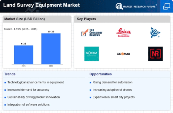
    As per MRFR analysis, the Land Survey Equipment Market Size was estimated at 6.282 USD Billion in 2024. The Land Survey Equipment industry is projected to grow from 6.57 USD Billion in 2025 to 10.29 USD Billion by 2035, exhibiting a compound annual growth rate (CAGR) of 4.59 during the forecast period 2025 - 2035.

    Key Market Trends & Highlights

    The Land Survey Equipment Market is experiencing robust growth driven by technological advancements and increasing demand for geospatial data.

    • North America remains the largest market for land survey equipment, driven by extensive infrastructure projects.
    • Asia-Pacific is the fastest-growing region, reflecting rapid urbanization and development needs.
    • Total Stations dominate the market, while Electronic Distance Meters are emerging as the fastest-growing segment.
    • Technological advancements and the growing demand for geospatial data are key drivers propelling market expansion.

    Market Size & Forecast

    2024 Market Size 6.282 (USD Billion)
    2035 Market Size 10.29 (USD Billion)
    CAGR (2025 - 2035) 4.59%

    Major Players

    Topcon (JP), Leica Geosystems (CH), Trimble (US), Sokkia (JP), GeoMax (CH), Nikon (JP), Futtura (US), C.Scope (GB), Riegl (AT)

    Land Survey Equipment Market Trends

    The Land Survey Equipment Market is currently experiencing a dynamic evolution, driven by advancements in technology and increasing demand for precise measurement tools. The integration of automation and digital solutions appears to enhance the efficiency and accuracy of surveying processes. As industries such as construction, agriculture, and environmental management continue to expand, the need for reliable land survey equipment becomes more pronounced. Furthermore, the growing emphasis on sustainable practices may influence the types of equipment being developed and utilized, as stakeholders seek to minimize environmental impact while maximizing productivity. In addition, the Land Survey Equipment Market seems to be influenced by the rising trend of remote sensing technologies. These innovations allow for comprehensive data collection and analysis, which could potentially transform traditional surveying methods. The market landscape is likely to witness increased competition as manufacturers strive to differentiate their offerings through enhanced features and capabilities. Overall, the Land Survey Equipment Market is poised for growth, with various factors contributing to its ongoing transformation and adaptation to modern demands.

    Technological Advancements

    The Land Survey Equipment Market is witnessing a surge in technological innovations, particularly in the realm of automation and digitalization. These advancements facilitate more efficient data collection and processing, thereby improving overall accuracy in surveying tasks.

    Sustainability Focus

    There is a growing emphasis on sustainable practices within the Land Survey Equipment Market. Stakeholders are increasingly seeking equipment that minimizes environmental impact, aligning with broader trends towards eco-friendly operations in various industries.

    Remote Sensing Integration

    The integration of remote sensing technologies is reshaping the Land Survey Equipment Market. This trend allows for enhanced data collection and analysis, potentially revolutionizing traditional surveying methodologies and expanding the scope of applications.

    The ongoing evolution of land survey equipment is likely to enhance precision and efficiency in various sectors, reflecting a broader trend towards technological integration in surveying practices.

    U.S. Geological Survey

    Land Survey Equipment Market Drivers

    Emerging Markets and Urbanization

    The Land Survey Equipment Market is benefiting from urbanization trends in emerging markets. As populations in these regions continue to grow, there is an increasing need for urban planning and development. This urban expansion necessitates accurate land surveys to facilitate the development of housing, transportation, and public services. The demand for land survey equipment is expected to rise as cities expand and require detailed mapping and planning. Additionally, emerging markets are often characterized by less developed infrastructure, which presents unique challenges that advanced surveying technologies can address. The potential for growth in these markets is substantial, as investments in urban development are projected to increase significantly in the coming years.

    Growing Demand for Geospatial Data

    The Land Survey Equipment Market is witnessing a growing demand for geospatial data across various sectors. Industries such as construction, mining, and environmental management increasingly rely on accurate geospatial information for decision-making and project planning. The proliferation of Geographic Information Systems (GIS) and the need for spatial analysis are propelling the demand for advanced land survey equipment. Recent reports indicate that the geospatial analytics market is expected to grow significantly, which in turn will drive the land survey equipment market. As organizations recognize the value of data-driven insights, the need for high-quality surveying tools that can deliver precise geospatial data is likely to increase.

    Increased Infrastructure Development

    The Land Survey Equipment Market is poised for growth due to the surge in infrastructure development projects worldwide. Governments and private sectors are investing heavily in transportation, urban development, and renewable energy projects. This investment necessitates accurate land surveying to ensure compliance with regulations and to optimize land use. For example, the construction of new highways and bridges requires extensive surveying to assess land topography and environmental impact. The demand for land survey equipment is expected to rise in tandem with these projects, as accurate data is crucial for successful execution. Recent estimates suggest that infrastructure spending could reach trillions of dollars over the next decade, thereby significantly boosting the land survey equipment market.

    Regulatory Compliance and Land Management

    The Land Survey Equipment Market is influenced by the increasing need for regulatory compliance in land management. As environmental regulations become more stringent, accurate land surveys are essential for compliance with zoning laws and land use policies. This trend is particularly evident in sectors such as real estate and agriculture, where precise land measurements are critical for legal and operational purposes. The demand for advanced surveying equipment that can provide reliable data is likely to grow as organizations seek to avoid legal repercussions and ensure sustainable land use. Furthermore, the rise in land disputes and the need for clear property boundaries are driving the adoption of sophisticated survey technologies.

    Technological Advancements in Survey Equipment

    The Land Survey Equipment Market is experiencing a notable transformation due to rapid technological advancements. Innovations such as 3D laser scanning, drone surveying, and GPS technology are enhancing the accuracy and efficiency of land surveys. For instance, the integration of drones has reduced survey time significantly, allowing for more comprehensive data collection. According to recent data, the market for drone-based surveying equipment is projected to grow at a compound annual growth rate of over 15% in the coming years. This trend indicates a shift towards more sophisticated tools that not only improve precision but also reduce labor costs. As these technologies become more accessible, they are likely to drive further adoption within the industry.

    Market Segment Insights

    By Technology: Total Stations (Largest) vs. Electronic Distance Meters (Fastest-Growing)

    The Land Survey Equipment Market is witnessing a diverse distribution in technology segments. Total Stations hold the largest share, owing to their versatile functionality that integrates electronic distance measurement with angle measurement capabilities, making them indispensable for land surveying professionals. Following closely are Electronic Distance Meters, which, while having a smaller share, are rapidly gaining ground as they offer efficiency and accuracy in measuring distances, essential for modern surveying applications.

    Technology: Total Stations (Dominant) vs. Electronic Distance Meters (Emerging)

    Total Stations are the dominant technology in the Land Survey Equipment Market, offering a comprehensive solution that combines angles and distances into a single platform, thus streamlining the surveying process. Their robustness and adaptability across various survey types make them a preferred choice among surveying professionals. On the other hand, Electronic Distance Meters are emerging rapidly due to their lightweight, portable design and exceptional precision in distance measurement. They represent an essential advancement in the field, enabling faster and more accurate surveying tasks, thus appealing to a broader range of users, including those in construction and environmental studies.

    By Accuracy: High Accuracy (Dominant) vs. Ultra-High Accuracy (Fastest-Growing)

    In the Land Survey Equipment Market, the accuracy segments are categorized into Standard Accuracy, High Accuracy, and Ultra-High Accuracy. The High Accuracy segment holds a significant share of the market, primarily due to the increasing demand for precise measurements in construction, engineering, and archaeological projects. Ultra-High Accuracy, although smaller in comparison, is rapidly gaining traction among high-end applications, such as geodesy and high-resolution topographic surveys. As industries continue to prioritize precision, the market share is increasingly tilting towards high and ultra-high accuracy solutions. The growth of the High Accuracy segment is primarily driven by the integration of advanced technologies like GNSS and laser scanning, which enhance measurement capabilities. Meanwhile, the Ultra-High Accuracy segment is identified as the fastest-growing due to the rising adoption of these tools in specialized industries, including mining, oil and gas, and defense. Factors such as increasing government investments in infrastructure projects and advancements in survey equipment technology are also propelling growth in these segments.

    High Accuracy (Dominant) vs. Ultra-High Accuracy (Emerging)

    High Accuracy land survey equipment, defined by precision ranges of 0.1 cm to 0.5 cm, is widely adopted for various applications including urban planning and road construction. This segment has seen robust market leadership due to its balance of cost and precision, making it accessible for a wide range of customers. Conversely, Ultra-High Accuracy equipment, offering precision of less than 0.1 cm, positions itself as an emerging segment aimed at specialized fields. This segment, while smaller, is characterized by advanced technological features like real-time data processing and superior measurement capabilities, which attract industries with stringent accuracy requirements. As the market evolves, both segments are poised for growth, driven by trends in automation and digital transformation in surveying.

    By Application: Construction Surveying (Largest) vs. Hydrographic Surveying (Fastest-Growing)

    In the Land Survey Equipment Market, the application segment is diverse, with Construction Surveying holding the largest share. This segment primarily focuses on providing precise measurements and data necessary for building projects, making it integral to the construction sector's growth. Following closely are Boundary and Cadastral Surveying and Topographic Surveying, which cater to land management and planning needs. Engineering Surveying is also significant, supporting infrastructure development, while Hydrographic Surveying is witnessing rapid growth due to increasing demands for underwater mapping and data collection.

    Surveying Types: Construction (Dominant) vs. Hydrographic (Emerging)

    Construction Surveying is established as the dominant application within the Land Survey Equipment Market, with its focus on accuracy and reliability in measurements critical for successful construction projects. It involves various techniques and tools that ensure compliance with zoning laws and building codes. On the other hand, Hydrographic Surveying is emerging as a vital segment, driven by the growing importance of maritime navigation, environmental monitoring, and coastal management. This application employs specialized equipment to collect data on water bodies, facilitating better resource management and infrastructure development in aquatic environments.

    By Industry: Land Surveying (Largest) vs. Construction (Fastest-Growing)

    The Land Survey Equipment Market is predominantly led by the Land Surveying industry, which commands significant market share due to the increasing demand for infrastructure development and urban planning. This segment's importance is underlined by the consistent need for accurate measurement and mapping for various projects, ensuring its status as the largest within the market. Following closely is the Construction industry, which is experiencing remarkable growth, driven by the revitalization of construction activities and an upsurge in residential and commercial projects. As the market evolves, both the Land Surveying and Construction segments are benefiting from technological advancements in surveying equipment such as drones and 3D scanning. The Construction industry's rapid adoption of these technologies to enhance precision and efficiency is propelling its growth, making it the fastest-growing segment. Furthermore, policy shifts favoring infrastructural development are expected to further boost both segments, reinforcing their pivotal roles in the land survey equipment landscape.

    Land Surveying (Dominant) vs. Construction (Emerging)

    The Land Surveying segment remains dominant in the Land Survey Equipment Market, characterized by its foundational role in mapping and analysis for both governmental and private projects. This segment encompasses technologies like total stations, GPS, and laser scanning, crucial for land delineation and topographical assessments. The stability of the Land Surveying segment is supported by continual investments in public infrastructure, urbanization, and regulatory requirements for land registration. Conversely, the Construction segment, while emerging, shows dynamic growth potential fueled by increasing construction activities across various sectors. Innovative methods, including Building Information Modeling (BIM) and the integration of modern surveying technologies, are enhancing efficiency and accuracy in project execution. The Construction industry is likely to expand rapidly as it adapts to new trends and technologies, shaking up the market landscape.

    Get more detailed insights about Land Survey Equipment Market

    Regional Insights

    North America : Technological Innovation Leader

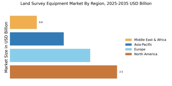
    North America is the largest market for land survey equipment, holding approximately 40% of the global market share. The region's growth is driven by advancements in technology, increasing infrastructure projects, and stringent regulations promoting accurate land measurement. The demand for high-precision equipment is rising, particularly in the construction and civil engineering sectors, which are bolstered by government investments in infrastructure. The United States and Canada are the leading countries in this region, with the U.S. accounting for the majority of the market share. Key players such as Trimble and Topcon dominate the competitive landscape, offering innovative solutions that cater to various surveying needs. The presence of established companies and a robust distribution network further enhance market growth, making North America a hub for land survey equipment innovation.

    Europe : Regulatory-Driven Market Growth

    Europe is the second-largest market for land survey equipment, holding around 30% of the global market share. The region's growth is fueled by increasing investments in infrastructure, urban development, and environmental monitoring. Regulatory frameworks, such as the European Union's directives on land use and construction, are significant catalysts for demand, ensuring compliance with high standards of accuracy and safety in surveying practices. Germany, the UK, and France are the leading countries in this market, with Germany being the largest contributor. The competitive landscape features key players like Leica Geosystems and GeoMax, which are known for their advanced technologies and comprehensive product offerings. The presence of these companies, along with a focus on sustainability and innovation, positions Europe as a critical player in the land survey equipment market.

    Asia-Pacific : Emerging Market Potential

    Asia-Pacific is witnessing rapid growth in the land survey equipment market, accounting for approximately 20% of the global share. The region's expansion is driven by urbanization, infrastructure development, and increasing government initiatives to improve land management practices. Countries like China and India are leading this growth, supported by significant investments in construction and real estate sectors, which are essential for economic development. China is the largest market in the region, with a growing demand for advanced surveying technologies. The competitive landscape includes key players such as Sokkia and Nikon, which are expanding their presence through strategic partnerships and local manufacturing. The increasing adoption of digital technologies in surveying practices is further enhancing market dynamics, making Asia-Pacific a promising region for future growth.

    Middle East and Africa : Resource-Rich Market Dynamics

    The Middle East and Africa region is emerging as a significant market for land survey equipment, holding about 10% of the global market share. The growth is primarily driven by ongoing infrastructure projects, urbanization, and the need for accurate land measurement in resource management. Countries like the UAE and South Africa are at the forefront, with substantial investments in construction and mining sectors, which are critical for regional development. The competitive landscape features both local and international players, with companies like C.Scope and Riegl making notable contributions. The presence of these key players, along with government initiatives to enhance land surveying practices, is fostering a conducive environment for market growth. As the region continues to develop, the demand for advanced surveying technologies is expected to rise significantly.

    Key Players and Competitive Insights

    The Land Survey Equipment Market is currently characterized by a dynamic competitive landscape, driven by technological advancements and increasing demand for precision in surveying applications. Key players such as Topcon (Japan), Trimble (US), and Leica Geosystems (Switzerland) are at the forefront, each adopting distinct strategies to enhance their market positioning. Topcon (Japan) focuses on innovation through the integration of advanced technologies like artificial intelligence and machine learning into their surveying solutions, thereby improving accuracy and efficiency. Meanwhile, Trimble (US) emphasizes strategic partnerships and acquisitions to expand its product offerings and market reach, particularly in the construction and agriculture sectors. Leica Geosystems (Switzerland) is also notable for its commitment to digital transformation, investing heavily in cloud-based solutions that facilitate real-time data sharing and collaboration among surveyors.

    The business tactics employed by these companies reflect a broader trend towards localization and supply chain optimization. The market appears moderately fragmented, with several players vying for dominance while also collaborating on various projects. This competitive structure allows for a diverse range of products and services, catering to different segments of the market. The collective influence of these key players shapes the landscape, as they continuously adapt to emerging technologies and customer needs.

    In August 2025, Topcon (Japan) announced the launch of its new AI-driven surveying software, which is designed to enhance data accuracy and streamline workflows for surveyors. This strategic move underscores Topcon's commitment to innovation and positions the company to capture a larger share of the market by addressing the growing demand for intelligent surveying solutions. The introduction of this software is likely to set a new standard in the industry, compelling competitors to enhance their own offerings.

    In September 2025, Trimble (US) completed the acquisition of a leading drone technology firm, which significantly bolsters its capabilities in aerial surveying. This acquisition is strategically important as it allows Trimble to integrate drone technology into its existing product suite, thereby providing customers with comprehensive surveying solutions that combine ground and aerial data collection. Such a move not only enhances Trimble's competitive edge but also reflects the increasing importance of drone technology in the surveying sector.

    In July 2025, Leica Geosystems (Switzerland) launched a new line of portable laser scanning equipment aimed at improving field productivity. This product introduction is indicative of the company's focus on enhancing user experience and operational efficiency. By offering portable solutions, Leica Geosystems is likely to attract a broader customer base, particularly in sectors where mobility and ease of use are paramount.

    As of October 2025, the Land Survey Equipment Market is witnessing significant trends such as digitalization, sustainability, and the integration of artificial intelligence. These trends are reshaping competitive dynamics, with companies increasingly forming strategic alliances to leverage complementary strengths. The shift from price-based competition to a focus on innovation, technology, and supply chain reliability is becoming evident. Moving forward, differentiation will likely hinge on the ability to deliver cutting-edge solutions that meet the evolving needs of customers in a rapidly changing environment.

    Key Companies in the Land Survey Equipment Market market include

    Industry Developments

    • Q2 2024: Trimble Introduces the Trimble R980 GNSS System for Land Surveying Applications Trimble announced the launch of the Trimble R980 GNSS system, designed to provide surveyors with enhanced positioning accuracy and field productivity for land surveying projects.
    • Q2 2024: Hexagon launches Leica AP20 AutoPole for automated total station workflows Hexagon’s Geosystems division introduced the Leica AP20 AutoPole, an innovative solution that automates pole height and orientation measurements, streamlining total station workflows for land surveyors.
    • Q1 2024: Topcon Announces New GTL-1200 Scanning Robotic Total Station Topcon Positioning Systems launched the GTL-1200, a new scanning robotic total station that integrates high-speed 3D laser scanning with traditional surveying capabilities for construction and land development.
    • Q2 2024: CHC Navigation Unveils i83 GNSS Receiver for Surveying Professionals CHC Navigation released the i83 GNSS receiver, offering advanced multi-constellation tracking and real-time connectivity features for land surveyors.
    • Q1 2024: Stonex Launches S990+ GNSS Receiver for Land Surveying Stonex introduced the S990+ GNSS receiver, designed to deliver high-precision positioning and robust performance for land surveying and geospatial applications.
    • Q2 2024: Trimble and Esri Announce Strategic Collaboration to Advance Geospatial Data Integration Trimble and Esri announced a partnership to integrate Trimble’s GNSS and survey solutions with Esri’s ArcGIS platform, enhancing geospatial data workflows for land survey professionals.
    • Q1 2024: Hi-Target Launches V200 GNSS RTK System for Surveying Hi-Target released the V200 GNSS RTK system, providing surveyors with a compact, high-accuracy solution for land surveying and mapping tasks.
    • Q2 2024: Leica Geosystems Introduces Leica BLK360 G2 Imaging Laser Scanner Leica Geosystems launched the BLK360 G2, a next-generation imaging laser scanner designed for rapid, high-accuracy 3D capture in land surveying and construction.
    • Q1 2024: Topcon and Bentley Systems Expand Collaboration for Digital Construction and Surveying Topcon and Bentley Systems announced an expanded partnership to integrate Topcon’s survey equipment with Bentley’s digital construction software, aiming to improve data flow and project efficiency for land surveyors.
    • Q2 2024: Trimble Opens New Manufacturing Facility in Colorado for Surveying Equipment Trimble announced the opening of a new manufacturing facility in Colorado dedicated to the production of advanced land surveying equipment, supporting increased demand and innovation.
    • Q1 2024: Kolida Launches KTS-472R10 Total Station for Surveying Market Kolida Instrument Co. introduced the KTS-472R10 total station, featuring improved measurement speed and accuracy for land surveyors.
    • Q2 2024: CHC Navigation Announces Partnership with GeoMax for Surveying Solutions CHC Navigation and GeoMax announced a partnership to jointly develop and distribute advanced surveying solutions, targeting the global land survey equipment market.

    Future Outlook

    Land Survey Equipment Market Future Outlook

    The Land Survey Equipment Market is projected to grow at a 4.59% CAGR from 2024 to 2035, driven by technological advancements, urbanization, and infrastructure development.

    New opportunities lie in:

    • Integration of AI-driven analytics for enhanced data accuracy.
    • Development of portable, solar-powered surveying equipment.
    • Expansion into emerging markets with tailored solutions.

    By 2035, the market is expected to achieve robust growth, reflecting evolving industry demands.

    Market Segmentation

    Land Survey Equipment Market Accuracy Outlook

    • Standard Accuracy (0.5 cm to 10 cm)
    • High Accuracy (0.1 cm to 0.5 cm)
    • Ultra-High Accuracy (less than 0.1 cm)

    Land Survey Equipment Market Industry Outlook

    • Land Surveying
    • Construction
    • Mining
    • Agriculture
    • Infrastructure Development

    Land Survey Equipment Market Technology Outlook

    • Total Stations
    • Electronic Distance Meters
    • Automatic Levels
    • Laser Scanners
    • Positioning Systems (GPS)

    Land Survey Equipment Market Application Outlook

    • Boundary and Cadastral Surveying
    • Construction Surveying
    • Topographic Surveying
    • Engineering Surveying
    • Hydrographic Surveying

    Report Scope

    MARKET SIZE 20246.282(USD Billion)
    MARKET SIZE 20256.57(USD Billion)
    MARKET SIZE 203510.29(USD Billion)
    COMPOUND ANNUAL GROWTH RATE (CAGR)4.59% (2024 - 2035)
    REPORT COVERAGERevenue Forecast, Competitive Landscape, Growth Factors, and Trends
    BASE YEAR2024
    Market Forecast Period2025 - 2035
    Historical Data2019 - 2024
    Market Forecast UnitsUSD Billion
    Key Companies ProfiledMarket analysis in progress
    Segments CoveredMarket segmentation analysis in progress
    Key Market OpportunitiesIntegration of advanced technologies like drones and artificial intelligence in the Land Survey Equipment Market.
    Key Market DynamicsTechnological advancements and regulatory changes drive innovation and competition in the Land Survey Equipment Market.
    Countries CoveredNorth America, Europe, APAC, South America, MEA

    Leave a Comment

    FAQs

    What is the projected market valuation of the Land Survey Equipment Market by 2035?

    The Land Survey Equipment Market is projected to reach a valuation of 10.29 USD Billion by 2035.

    What was the market valuation of the Land Survey Equipment Market in 2024?

    In 2024, the overall market valuation was 6.282 USD Billion.

    What is the expected CAGR for the Land Survey Equipment Market during the forecast period 2025 - 2035?

    The expected CAGR for the Land Survey Equipment Market during the forecast period 2025 - 2035 is 4.59%.

    Which companies are considered key players in the Land Survey Equipment Market?

    Key players in the Land Survey Equipment Market include Topcon, Leica Geosystems, Trimble, Sokkia, GeoMax, Nikon, Futtura, C.Scope, and Riegl.

    What are the projected revenues for Total Stations in the Land Survey Equipment Market by 2035?

    The projected revenues for Total Stations in the Land Survey Equipment Market are expected to reach 2.4 USD Billion by 2035.

    How does the market for Electronic Distance Meters appear to be evolving by 2035?

    The market for Electronic Distance Meters is projected to grow to 1.9 USD Billion by 2035.

    What is the anticipated revenue for Hydrographic Surveying applications by 2035?

    Hydrographic Surveying applications are anticipated to generate revenues of 2.79 USD Billion by 2035.

    What segment of the Land Survey Equipment Market is expected to see the highest growth in accuracy by 2035?

    The Ultra-High Accuracy segment, with revenues projected at 3.29 USD Billion by 2035, is expected to see the highest growth.

    What is the projected revenue for Construction Surveying applications by 2035?

    Construction Surveying applications are projected to reach revenues of 2.0 USD Billion by 2035.

    How does the Land Surveying industry segment appear to be performing by 2035?

    The Land Surveying industry segment is expected to grow to 2.4 USD Billion by 2035.

    Download Free Sample

    Kindly complete the form below to receive a free sample of this Report

    Case Study
    Chemicals and Materials

    Compare Licence

    ×
    Features License Type
    Single User Multiuser License Enterprise User
    Price $4,950 $5,950 $7,250
    Maximum User Access Limit 1 User Upto 10 Users Unrestricted Access Throughout the Organization
    Free Customization
    Direct Access to Analyst
    Deliverable Format
    Platform Access
    Discount on Next Purchase 10% 15% 15%
    Printable Versions