Integration of Big Data Analytics
The integration of big data analytics into the Agricultural Mapping and Imaging Market is transforming how agricultural data is utilized. By leveraging vast amounts of data collected from various sources, including satellite imagery and sensor networks, farmers can gain insights that were previously unattainable. This analytical capability allows for better forecasting, risk assessment, and decision-making in agriculture. The market is witnessing a shift towards data-centric approaches, with projections indicating that the use of big data in agriculture could enhance productivity by up to 20%. This trend underscores the importance of advanced mapping and imaging technologies in driving efficiency and innovation in the agricultural sector.
Government Initiatives and Support
Government initiatives play a crucial role in the Agricultural Mapping and Imaging Market, as many countries are implementing policies to promote the adoption of advanced agricultural technologies. These initiatives often include funding for research and development, subsidies for technology adoption, and training programs for farmers. Such support is essential for encouraging the integration of mapping and imaging technologies into traditional farming practices. Recent data suggests that government investments in agricultural technology are expected to increase, further driving the growth of the agricultural mapping and imaging market. This trend indicates a commitment to enhancing food security and sustainability.
Rising Demand for Precision Agriculture
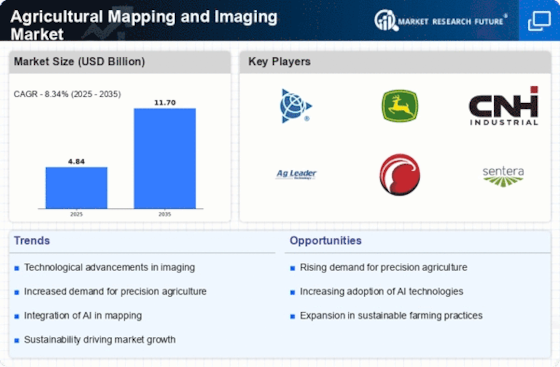
The Agricultural Mapping and Imaging Market is witnessing a rising demand for precision agriculture, which emphasizes the use of data-driven techniques to enhance farming efficiency. Farmers are increasingly adopting mapping and imaging technologies to monitor crop performance and manage resources effectively. This trend is supported by the growing awareness of the benefits of precision agriculture, including reduced input costs and increased yields. Market data indicates that the precision agriculture segment is expected to account for a substantial share of the overall agricultural mapping and imaging market, reflecting a shift towards more sustainable and efficient farming practices.
Technological Advancements in Imaging Techniques
The Agricultural Mapping and Imaging Market is experiencing a surge in technological advancements, particularly in imaging techniques. Innovations such as multispectral and hyperspectral imaging are enhancing the precision of agricultural assessments. These technologies allow for detailed analysis of crop health, soil conditions, and pest infestations. As a result, farmers can make informed decisions that optimize yield and resource use. The market for agricultural imaging is projected to grow significantly, with estimates suggesting a compound annual growth rate of over 15% in the coming years. This growth is driven by the increasing need for accurate data to support sustainable farming practices and improve productivity.
Growing Awareness of Environmental Sustainability
The Agricultural Mapping and Imaging Market is increasingly influenced by the growing awareness of environmental sustainability among consumers and farmers alike. As the agricultural sector faces pressure to reduce its environmental footprint, mapping and imaging technologies offer solutions for more efficient resource management. These technologies enable farmers to monitor water usage, soil health, and crop conditions, thereby minimizing waste and promoting sustainable practices. Market trends indicate that the demand for environmentally friendly agricultural solutions is on the rise, suggesting that the agricultural mapping and imaging market will continue to expand as sustainability becomes a priority for stakeholders.


