• Cat-intel
  • MedIntelliX
  • Resources
  • About Us
  • Request Free Sample ×

    Kindly complete the form below to receive a free sample of this Report

    Leading companies partner with us for data-driven Insights

    clients tt-cursor
    Hero Background

    Airborne Light Detection and Ranging System Market

    ID: MRFR/A&D/33200-HCR
    111 Pages
    Sejal Akre
    October 2025

    Airborne Light Detection and Ranging System Market Research Report By Technology (Single-Photon Lidar, Multi-Photon Lidar, Flash Lidar, Time-of-Flight Lidar, Frequency Modulated Continuous Wave Lidar), By Application (Mapping and Surveying, Autonomous Vehicles, Precision Agriculture, Infrastructure Inspection, Disaster Management), By Platform (Airborne, Terrestrial, Mobile, Fixed), By Form Factor (Ruggedized, Compact, Miniaturized), By Range (Short-Range (100 m), Mid-Range (100 m - 1 km), Long-Range (>1 km)) and By Regional (North Americ...

    Share:
    Download PDF ×

    We do not share your information with anyone. However, we may send you emails based on your report interest from time to time. You may contact us at any time to opt-out.

    Airborne Light Detection and Ranging System Market Infographic
    Purchase Options

    Airborne Light Detection and Ranging System Market Summary

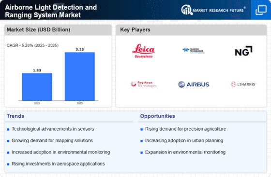
    As per MRFR analysis, the Airborne Light Detection and Ranging System Market Size was estimated at 1.832 USD Billion in 2024. The Airborne Light Detection and Ranging System industry is projected to grow from 1.929 USD Billion in 2025 to 3.227 USD Billion by 2035, exhibiting a compound annual growth rate (CAGR) of 5.28 during the forecast period 2025 - 2035.

    Key Market Trends & Highlights

    The Airborne Light Detection and Ranging System Market is poised for substantial growth driven by technological advancements and increasing demand for precision mapping.

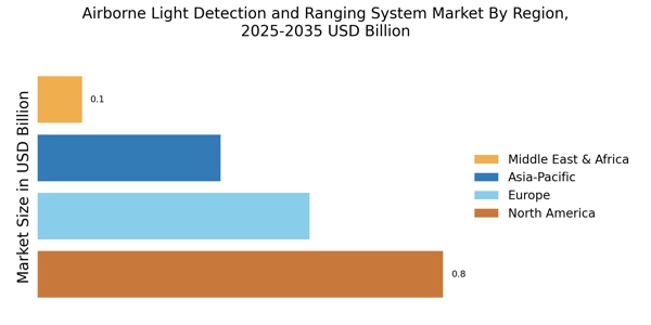
    • North America remains the largest market for Airborne Lidar systems, driven by extensive infrastructure development and environmental monitoring initiatives.
    • The Asia-Pacific region is emerging as the fastest-growing market, fueled by rapid urbanization and advancements in sensor technology.
    • Single-Photon Lidar technology dominates the market, while Multi-Photon Lidar is gaining traction due to its enhanced capabilities and applications.
    • Key market drivers include the increased demand for precision mapping and the expansion of infrastructure development projects, which are likely to propel market growth.

    Market Size & Forecast

    2024 Market Size 1.832 (USD Billion)
    2035 Market Size 3.227 (USD Billion)
    CAGR (2025 - 2035) 5.28%

    Major Players

    Leica Geosystems (CH), Teledyne Technologies (US), Northrop Grumman (US), Raytheon Technologies (US), Airbus (FR), L3Harris Technologies (US), Woolpert (US), GeoIQ (US), RIEGL Laser Measurement Systems (AT)

    Airborne Light Detection and Ranging System Market Trends

    The Airborne Light Detection and Ranging System Market is currently experiencing a notable evolution, driven by advancements in technology and increasing applications across various sectors. This market encompasses systems that utilize laser light to measure distances and create high-resolution maps of the Earth's surface. The growing demand for precise topographical data in industries such as agriculture, forestry, and urban planning is propelling the adoption of these systems. Furthermore, the integration of artificial intelligence and machine learning into airborne LiDAR technology is enhancing data processing capabilities, thereby improving the accuracy and efficiency of mapping projects. As environmental concerns rise, the market is also witnessing a shift towards sustainable practices, with LiDAR being employed for monitoring deforestation and assessing natural resources. In addition to technological advancements, the Airborne Light Detection and Ranging System Market is influenced by regulatory frameworks and funding initiatives aimed at promoting geospatial technologies. Governments are increasingly recognizing the value of accurate spatial data for infrastructure development and disaster management. This recognition is likely to foster collaborations between public and private sectors, leading to innovative solutions and expanded market opportunities. As the market continues to mature, it appears poised for growth, with potential applications in autonomous vehicles and smart city initiatives, indicating a promising future for airborne LiDAR systems.

    Technological Advancements

    Recent innovations in sensor technology and data processing algorithms are enhancing the capabilities of airborne LiDAR systems. These advancements enable higher resolution mapping and more efficient data collection, which could lead to broader adoption across various industries.

    Sustainability Focus

    There is a growing emphasis on utilizing airborne LiDAR for environmental monitoring and resource management. This trend suggests that organizations are increasingly leveraging these systems to support sustainable practices, such as tracking deforestation and managing natural resources.

    Regulatory Support

    Government initiatives and funding programs aimed at promoting geospatial technologies are likely to bolster the Airborne Light Detection and Ranging System Market. This support may facilitate partnerships between public entities and private companies, fostering innovation and expanding market reach.

    The increasing demand for high-resolution topographic data is driving advancements in airborne light detection and ranging technologies, which are becoming integral to various applications including environmental monitoring and urban planning.

    U.S. Geological Survey

    Airborne Light Detection and Ranging System Market Drivers

    Advancements in Sensor Technology

    Technological innovations in sensor capabilities are significantly influencing the Airborne Light Detection and Ranging System Market. Enhanced sensor technologies, such as multi-spectral and hyperspectral LiDAR, are enabling more detailed data collection and analysis. These advancements allow for applications in agriculture, where precision farming techniques are increasingly adopted. The integration of advanced sensors is expected to improve data accuracy and reduce operational costs, thereby attracting more investments into the Airborne Light Detection and Ranging System Market. As a result, the market is likely to witness a surge in demand for sophisticated airborne LiDAR solutions.

    Increased Demand for Precision Mapping

    The Airborne Light Detection and Ranging System Market is experiencing heightened demand for precision mapping solutions. This demand is driven by various sectors, including urban planning, forestry, and environmental monitoring. The ability of LiDAR systems to provide high-resolution topographic data enables stakeholders to make informed decisions. For instance, the market for airborne LiDAR is projected to reach USD 1.2 billion by 2026, reflecting a compound annual growth rate of approximately 15%. This growth indicates a robust interest in technologies that enhance mapping accuracy and efficiency, thereby propelling the Airborne Light Detection and Ranging System Market forward.

    Increased Adoption in Disaster Management

    The Airborne Light Detection and Ranging System Market is witnessing increased adoption in disaster management applications. LiDAR technology plays a crucial role in assessing damage and planning recovery efforts following natural disasters. Its ability to quickly generate detailed topographic maps aids in effective response strategies. As climate-related disasters become more frequent, the demand for reliable data to support emergency management is likely to rise. This trend suggests that the Airborne Light Detection and Ranging System Market will continue to grow, driven by the need for advanced technologies that enhance disaster preparedness and response.

    Growing Environmental Monitoring Initiatives

    The Airborne Light Detection and Ranging System Market is benefiting from an increase in environmental monitoring initiatives. Governments and organizations are increasingly focusing on climate change, deforestation, and habitat loss, necessitating accurate data collection. LiDAR technology provides critical insights into forest structure and biomass, which are essential for effective environmental management. The market is projected to grow as more entities recognize the value of airborne LiDAR in supporting sustainability efforts. This trend suggests a promising future for the Airborne Light Detection and Ranging System Market, as it aligns with global environmental goals.

    Expansion of Infrastructure Development Projects

    Infrastructure development projects are a key driver for the Airborne Light Detection and Ranging System Market. As nations invest in transportation, utilities, and urban development, the need for precise topographical data becomes paramount. LiDAR technology facilitates efficient planning and execution of these projects by providing accurate terrain models. The market is expected to expand as more construction firms and government agencies adopt airborne LiDAR for site surveys and monitoring. This trend indicates a growing recognition of the benefits that LiDAR systems offer in enhancing project efficiency and reducing costs within the Airborne Light Detection and Ranging System Market.

    Market Segment Insights

    By Technology: Single-Photon Lidar (Largest) vs. Multi-Photon Lidar (Fastest-Growing)

    In the Airborne Light Detection and Ranging System Market, Single-Photon Lidar holds a significant share, being the largest technology segment due to its ability to deliver high precision and resolution in distance measurements. It is widely used in applications such as topographic mapping and environmental monitoring, which bolsters its market position. In contrast, Multi-Photon Lidar, while currently smaller in market share, is quickly gaining traction, especially in biomedical imaging and materials analysis applications, demonstrating substantial growth potential in the market.

    Technology: Single-Photon Lidar (Dominant) vs. Multi-Photon Lidar (Emerging)

    Single-Photon Lidar is recognized for its high sensitivity and accuracy, making it the dominant technology in airborne Lidar systems. Its applications, ranging from geological surveying to forestry management, showcase its versatility and broad usage in key industries. On the other hand, Multi-Photon Lidar is considered an emerging technology, known for its capabilities in capturing detailed information at the microscopic level, particularly in biophotonics and precise distance measurements. As industries increasingly seek advanced imaging solutions, Multi-Photon Lidar is expected to experience accelerated adoption, driven by technological advancements and growing interest in its applications.

    By Application: Mapping and Surveying (Largest) vs. Autonomous Vehicles (Fastest-Growing)

    In the Airborne Light Detection and Ranging System Market, the application of Mapping and Surveying holds the largest market share, driven by extensive use across various industries, including land appraisal, environmental studies, and urban planning. This segment benefits from the continued demand for precise geographic information systems (GIS) and enhanced data accuracy, leading to its dominant position. Meanwhile, the Autonomous Vehicles application is emerging rapidly, propelling significant technological advancements and increasing investments in the sector, with applications ranging from drone delivery systems to self-driving cars.

    Mapping and Surveying (Dominant) vs. Autonomous Vehicles (Emerging)

    Mapping and Surveying represents the dominant application segment, owing to its critical role in providing accurate topographical information essential for infrastructure development and urban planning. With a growing emphasis on GIS, this segment leverages state-of-the-art airborne LIDAR systems to deliver detailed and high-resolution data, significantly improving decision-making processes in governmental and commercial projects. On the other hand, Autonomous Vehicles are positioned as an emerging segment, fueled by advancements in automation technology and the increasing integration of airborne LIDAR solutions to enable precise navigation and obstacle detection, underscoring their potential to redefine transportation systems in the future.

    By Platform: Airborne (Largest) vs. Terrestrial (Fastest-Growing)

    In the Airborne Light Detection and Ranging System Market, the platform segment showcases a notable distribution among airborne, terrestrial, mobile, and fixed categories. Airborne platforms dominate the market due to their extensive operational range and capability to cover vast areas quickly, making them preferred for various applications such as environmental monitoring and disaster management. Terrestrial platforms follow, benefiting from a growing demand for ground-based surveying, enhancing their market relevance in urban development and infrastructure projects.

    Airborne (Dominant) vs. Terrestrial (Emerging)

    The Airborne platform stands out as the dominant category within the Airborne Light Detection and Ranging System Market, attributed to its advanced technology and the ability to gather high-resolution data over large geographical areas efficiently. Its use in aviation, mapping, and natural resource management underscores its critical role. On the other hand, Terrestrial platforms are emerging, gaining momentum due to their adaptability for specialized applications like construction monitoring and vegetation analysis. Their growth is driven by technological advancements and increased investment in ground-based research and infrastructure, positioning them as key players in this evolving market.

    By Form Factor: Ruggedized (Largest) vs. Miniaturized (Fastest-Growing)

    In the Airborne Light Detection and Ranging (LiDAR) System Market, the form factor segment exhibits a diverse distribution, showcasing Ruggedized as the most substantial category. This segment benefits from its application in challenging environments, making it appealing for defense and forestry-related operations. Compact forms, while significant, have taken a secondary role as emerging technologies adapt to miniature designs, leading to a more competitive landscape. Miniaturized LiDAR systems are gaining traction, indicating shifts in user preferences towards portability and efficiency, pointing to evolving market dynamics.

    Ruggedized (Dominant) vs. Miniaturized (Emerging)

    The Ruggedized segment of the Airborne LiDAR System market is characterized by its designed resilience and robustness, catering to applications in adverse environments. These systems are favored for their durability, making them essential for military, geological, and environmental surveys where reliability is paramount. In contrast, the Miniaturized segment is rapidly emerging as technological advancements enable the production of smaller, lighter systems without sacrificing performance. This trend caters to sectors seeking compact solutions with enhanced maneuverability, such as urban planning and disaster management, thus widening the market's reach and versatility.

    By Range: Short-Range (Largest) vs. Long-Range (Fastest-Growing)

    In the Airborne Light Detection and Ranging System Market, the Short-Range segment, covering distances up to 100 meters, holds the largest share. This segment benefits from applications in various industries such as agriculture and environmental monitoring, where precision over short distances is crucial. Conversely, the Long-Range segment, representing systems that operate beyond one kilometer, is emerging rapidly due to advancements in technology and increasing demand for accurate topographic mapping in sectors like forestry and urban planning.

    Short-Range (Dominant) vs. Long-Range (Emerging)

    The Short-Range segment stands out for its robust applications in precision farming and close-range surveillance tasks, providing invaluable data in localized areas. This dominance is fueled by the growing need for efficient land management practices and natural resource monitoring. Meanwhile, the Long-Range segment is gaining traction as new technologies enable accurate data collection over extended distances. The rise of smart city initiatives and infrastructure development are significant drivers of growth in this segment, as they require precise surveying capabilities to support urban expansion and planning.

    Get more detailed insights about Airborne Light Detection and Ranging System Market

    Regional Insights

    North America : Technological Innovation Leader

    North America is the largest market for Airborne Light Detection and Ranging (LiDAR) systems, accounting for approximately 45% of the global market share. The region's growth is driven by increasing demand for advanced mapping technologies in sectors such as forestry, agriculture, and urban planning. Regulatory support from agencies like the FAA and NASA further catalyzes market expansion, promoting the integration of LiDAR in various applications. The United States leads the North American market, with significant contributions from Canada. Key players such as Teledyne Technologies, Northrop Grumman, and L3Harris Technologies dominate the competitive landscape. The presence of advanced research institutions and a robust defense sector enhances innovation and adoption of LiDAR technologies, ensuring sustained growth in this region.

    Europe : Emerging Regulatory Frameworks

    Europe is witnessing significant growth in the Airborne LiDAR market, holding approximately 30% of the global share. The region's expansion is largely driven by stringent environmental regulations and a push for sustainable development. Countries are increasingly adopting LiDAR technology for environmental monitoring, urban planning, and infrastructure development, supported by EU initiatives aimed at enhancing data collection and analysis capabilities. Germany and the UK are the leading countries in this market, with a strong presence of companies like Airbus and RIEGL Laser Measurement Systems. The competitive landscape is characterized by collaborations between private firms and governmental agencies, fostering innovation. The European Space Agency's commitment to integrating LiDAR in satellite missions further enhances market prospects, positioning Europe as a key player in the global landscape.

    Asia-Pacific : Rapidly Growing Market Potential

    Asia-Pacific is rapidly emerging as a significant player in the Airborne LiDAR market, accounting for about 20% of the global share. The region's growth is fueled by increasing investments in infrastructure development, urbanization, and environmental monitoring. Countries like China and India are leading the charge, driven by government initiatives aimed at enhancing data collection for urban planning and disaster management, creating a favorable regulatory environment for LiDAR adoption. China is the largest market in the region, with substantial contributions from Australia and Japan. The competitive landscape features both local and international players, including Leica Geosystems and GeoIQ. The presence of a growing number of startups focusing on innovative applications of LiDAR technology is also notable, indicating a vibrant ecosystem that supports market growth and diversification.

    Middle East and Africa : Untapped Market Opportunities

    The Middle East and Africa region is gradually emerging in the Airborne LiDAR market, holding approximately 5% of the global share. The growth is primarily driven by increasing investments in infrastructure projects and urban development, particularly in countries like the UAE and South Africa. Government initiatives aimed at enhancing data collection for urban planning and environmental monitoring are creating a conducive environment for LiDAR technology adoption. The competitive landscape is still developing, with a mix of local and international players entering the market. Key players are beginning to establish a presence, focusing on sectors such as construction, mining, and environmental management. As awareness of LiDAR technology grows, the region is expected to see increased adoption, presenting significant opportunities for growth in the coming years.

    Key Players and Competitive Insights

    The Airborne Light Detection and Ranging (LiDAR) System Market is currently characterized by a dynamic competitive landscape, driven by advancements in technology and increasing demand for high-resolution mapping solutions across various sectors, including environmental monitoring, urban planning, and defense. Key players such as Teledyne Technologies (US), Northrop Grumman (US), and Airbus (FR) are strategically positioning themselves through innovation and partnerships. Teledyne Technologies (US) focuses on enhancing its sensor technologies, while Northrop Grumman (US) emphasizes its defense applications, and Airbus (FR) is expanding its capabilities in aerial data collection, collectively shaping a competitive environment that prioritizes technological advancement and operational efficiency.

    The market structure appears moderately fragmented, with several players vying for market share through localized manufacturing and optimized supply chains. Companies are increasingly localizing their production to reduce costs and improve responsiveness to regional demands. This strategy not only enhances supply chain reliability but also allows for tailored solutions that meet specific market needs, thereby influencing the competitive dynamics among key players.

    In August 2025, Teledyne Technologies (US) announced a partnership with a leading environmental consultancy to develop advanced LiDAR solutions aimed at enhancing forest management practices. This collaboration is significant as it underscores Teledyne's commitment to sustainability and positions the company as a leader in providing innovative solutions that address environmental challenges. The partnership is likely to enhance Teledyne's market presence and drive growth in the environmental sector.

    In September 2025, Northrop Grumman (US) unveiled a new airborne LiDAR system designed for precision mapping in defense applications. This launch is pivotal as it not only showcases Northrop Grumman's technological prowess but also reinforces its strategic focus on defense and security. The introduction of this system is expected to strengthen the company's competitive edge in the defense market, where accurate and timely data is crucial for operational success.

    In July 2025, Airbus (FR) expanded its LiDAR capabilities by acquiring a small technology firm specializing in drone-based mapping solutions. This acquisition is indicative of Airbus's strategy to diversify its offerings and enhance its technological capabilities in aerial data collection. By integrating drone technology with its existing LiDAR systems, Airbus is likely to improve its service delivery and expand its market reach, thereby solidifying its position in the competitive landscape.

    As of October 2025, the Airborne LiDAR System Market is witnessing trends such as digitalization, sustainability, and the integration of artificial intelligence. These trends are reshaping the competitive landscape, with companies increasingly forming strategic alliances to leverage complementary strengths. The shift from price-based competition to a focus on innovation, technology, and supply chain reliability is becoming evident, suggesting that future competitive differentiation will hinge on the ability to deliver advanced, reliable, and sustainable solutions.

    Key Companies in the Airborne Light Detection and Ranging System Market market include

    Industry Developments

    The Airborne Light Detection and Ranging System (LiDAR) market is expected to experience steady growth over the forecast period, driven by increasing demand for high-resolution mapping and surveying applications. Recent developments in LiDAR technology, such as the development of multi-spectral and hyperspectral LiDAR systems, are expanding the range of applications for the technology. Additionally, the growing adoption of LiDAR in autonomous vehicles and drones is expected to further drive market growth.Key players in the Airborne LiDAR market include Hexagon AB, Trimble Inc., and Topcon Corporation.

    These companies are investing heavily in research and development to enhance the capabilities and accuracy of their LiDAR systems.In 2023, the Airborne LiDAR market was valued at 1.66 billion USD and is projected to reach 2.632 billion USD by 2032, exhibiting a CAGR of 5.28% during the forecast period.

    Future Outlook

    Airborne Light Detection and Ranging System Market Future Outlook

    The Airborne Light Detection and Ranging System Market is projected to grow at a 5.28% CAGR from 2024 to 2035, driven by advancements in technology, increasing demand for precision mapping, and environmental monitoring.

    New opportunities lie in:

    • Development of integrated LiDAR solutions for urban planning and infrastructure development.
    • Expansion into emerging markets with tailored aerial survey services.
    • Partnerships with environmental agencies for biodiversity and conservation projects.

    By 2035, the market is expected to be robust, driven by innovation and diverse applications.

    Market Segmentation

    Airborne Light Detection and Ranging System Market Range Outlook

    • Short-Range (100 m)
    • Mid-Range (100 m - 1 km)
    • Long-Range (>1 km)

    Airborne Light Detection and Ranging System Market Platform Outlook

    • Airborne
    • Terrestrial
    • Mobile
    • Fixed

    Airborne Light Detection and Ranging System Market Technology Outlook

    • Single-Photon Lidar
    • Multi-Photon Lidar
    • Flash Lidar
    • Time-of-Flight Lidar
    • Frequency Modulated Continuous Wave Lidar

    Airborne Light Detection and Ranging System Market Application Outlook

    • Mapping and Surveying
    • Autonomous Vehicles
    • Precision Agriculture
    • Infrastructure Inspection
    • Disaster Management

    Airborne Light Detection and Ranging System Market Form Factor Outlook

    • Ruggedized
    • Compact
    • Miniaturized

    Report Scope

    MARKET SIZE 20241.832(USD Billion)
    MARKET SIZE 20251.929(USD Billion)
    MARKET SIZE 20353.227(USD Billion)
    COMPOUND ANNUAL GROWTH RATE (CAGR)5.28% (2024 - 2035)
    REPORT COVERAGERevenue Forecast, Competitive Landscape, Growth Factors, and Trends
    BASE YEAR2024
    Market Forecast Period2025 - 2035
    Historical Data2019 - 2024
    Market Forecast UnitsUSD Billion
    Key Companies ProfiledMarket analysis in progress
    Segments CoveredMarket segmentation analysis in progress
    Key Market OpportunitiesIntegration of advanced sensors enhances data accuracy in the Airborne Light Detection and Ranging System Market.
    Key Market DynamicsTechnological advancements and regulatory changes drive innovation and competition in the Airborne Light Detection and Ranging System market.
    Countries CoveredNorth America, Europe, APAC, South America, MEA

    Leave a Comment

    FAQs

    What is the current valuation of the Airborne Light Detection and Ranging System Market?

    The market valuation reached 1.832 USD Billion in 2024.

    What is the projected market size for the Airborne Light Detection and Ranging System Market by 2035?

    The market is expected to grow to 3.227 USD Billion by 2035.

    What is the expected CAGR for the Airborne Light Detection and Ranging System Market during the forecast period?

    The market is projected to experience a CAGR of 5.28% from 2025 to 2035.

    Which companies are considered key players in the Airborne Light Detection and Ranging System Market?

    Key players include Leica Geosystems, Teledyne Technologies, Northrop Grumman, and Raytheon Technologies.

    What are the primary technology segments within the Airborne Light Detection and Ranging System Market?

    The main technology segments include Single-Photon Lidar, Multi-Photon Lidar, and Flash Lidar.

    How does the market perform in terms of application segments?

    Application segments such as Mapping and Surveying and Precision Agriculture show valuations between 0.4 and 0.95 USD Billion.

    What platforms are utilized in the Airborne Light Detection and Ranging System Market?

    The market includes platforms like Airborne, Terrestrial, and Mobile, with Airborne valued at 0.732 to 1.267 USD Billion.

    What are the different form factors available in the Airborne Light Detection and Ranging System Market?

    Form factors include Ruggedized, Compact, and Miniaturized, with Ruggedized valued at 0.733 to 0.973 USD Billion.

    What range categories are present in the Airborne Light Detection and Ranging System Market?

    Range categories include Short-Range, Mid-Range, and Long-Range, with Mid-Range valued at 0.733 to 1.227 USD Billion.

    How does the market's growth trajectory appear for the next decade?

    The market's growth trajectory appears promising, with a projected increase in valuation from 1.832 USD Billion in 2024 to 3.227 USD Billion by 2035.

    Download Free Sample

    Kindly complete the form below to receive a free sample of this Report

    Case Study
    Chemicals and Materials

    Compare Licence

    ×
    Features License Type
    Single User Multiuser License Enterprise User
    Price $4,950 $5,950 $7,250
    Maximum User Access Limit 1 User Upto 10 Users Unrestricted Access Throughout the Organization
    Free Customization
    Direct Access to Analyst
    Deliverable Format
    Platform Access
    Discount on Next Purchase 10% 15% 15%
    Printable Versions