• Cat-intel
  • MedIntelliX
  • Resources
  • About Us
  • Request Free Sample ×

    Kindly complete the form below to receive a free sample of this Report

    Leading companies partner with us for data-driven Insights

    clients tt-cursor
    Hero Background

    Drone GIS Mapping Market

    ID: MRFR/A&D/28030-HCR
    128 Pages
    Sejal Akre
    October 2025

    Drone GIS Mapping Market Research Report By Technology (Lidar, Photogrammetry, Radar, Thermal Imaging, Multispectral Imaging), By Mapping Type (Orthomosaics, Digital Surface Models, Terrain Models, Contour Lines, 3D Models), By Application (Surveying and Mapping, Construction, Agriculture, Environmental Monitoring, Disaster Response), By Platform (Fixed-Wing Drones, Rotary-Wing Drones, Hybrid Drones), By End-User (Government Agencies, Private Companies, Non-Profit Organizations, Academic Institutions, Individual Users) and By Regional (Nort...

    Share:
    Download PDF ×

    We do not share your information with anyone. However, we may send you emails based on your report interest from time to time. You may contact us at any time to opt-out.

    Drone GIS Mapping Market  Infographic
    Purchase Options

    Drone GIS Mapping Market Summary

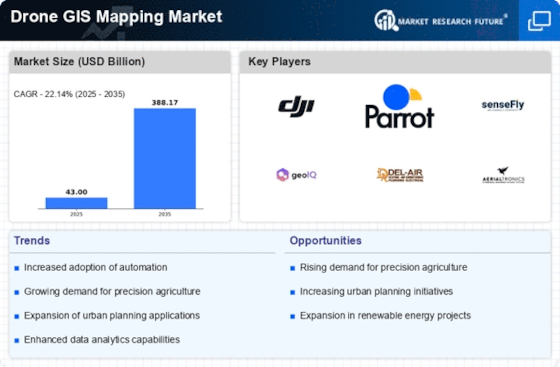
    The Global Drone GIS Mapping Market is projected to grow from 43.00 USD Billion in 2024 to 388.17 USD Billion by 2035.

    Key Market Trends & Highlights

    Drone GIS Mapping Key Trends and Highlights

    • The market is expected to experience a compound annual growth rate (CAGR) of 22.14% from 2025 to 2035.
    • By 2035, the market valuation is anticipated to reach 388.2 USD Billion, indicating substantial growth potential.
    • in 2024, the market is valued at 43.00 USD Billion, reflecting a burgeoning interest in drone technology for geographic information systems.
    • Growing adoption of drone technology due to its efficiency in data collection is a major market driver.

    Market Size & Forecast

    2024 Market Size 43.00 (USD Billion)
    2035 Market Size 388.17 (USD Billion)
    CAGR (2025-2035) 22.14%

    Major Players

    DJI, senseFly, GeoCue Group, Measure, Terra Drone Corporation, Aerodyne Group, PrecisionHawk, Eagle Aerial Solutions, Kespry, Skydio, Wingtra, Propeller Aero Solutions, Altavian, SlantRange, Cyberhawk, Airinov

    Drone GIS Mapping Market Trends

    Key market drivers include advancements in drone technology, increasing demand for accurate and timely geospatial data, and growing adoption in various sectors such as construction, agriculture, and environmental monitoring.

    Opportunities for growth lie in the integration of artificial intelligence and machine learning to automate data processing and analysis, the development of new applications and software, and the expansion into emerging markets.Recent trends include the adoption of multi-rotor drones with high-resolution cameras for improved data capture, the integration of thermal imaging for infrastructure inspection, and the use of drones for 3D modeling and volumetric calculations. These advancements enhance accuracy, efficiency, and the scope of applications for drone GIS mapping.

    The integration of drone technology into Geographic Information Systems is transforming data collection and analysis, enhancing precision and efficiency in various sectors, including agriculture, urban planning, and environmental monitoring.

    U.S. Geological Survey

    Drone GIS Mapping Market Drivers

    Market Growth Projections

    Technological Advancements

    The Global Drone GIS Mapping Market Industry is experiencing rapid growth due to continuous technological advancements in drone capabilities. Innovations in sensors, imaging technology, and data processing software enhance the accuracy and efficiency of mapping operations. For instance, the integration of LiDAR technology allows for high-resolution topographical mapping, which is increasingly utilized in urban planning and environmental monitoring. As a result, the market is projected to reach 43 USD Billion in 2024, reflecting the increasing reliance on drones for precise geographic data collection.

    Growing Environmental Awareness

    Increasing environmental awareness is driving the adoption of drone technology within the Global Drone GIS Mapping Market Industry. Drones are employed for environmental monitoring, habitat mapping, and disaster management, providing critical data for conservation efforts. For example, drones are utilized to assess deforestation rates and monitor wildlife populations, enabling more effective environmental policies. This heightened focus on sustainability is expected to propel market growth, as organizations seek innovative solutions to address environmental challenges.

    Cost Efficiency and Accessibility

    Cost efficiency and accessibility are significant factors propelling the Global Drone GIS Mapping Market Industry. Drones offer a more affordable alternative to traditional surveying methods, reducing labor costs and time required for data collection. This affordability makes drone technology accessible to a broader range of industries, including small and medium-sized enterprises. As the technology becomes more widespread, it is anticipated that the market will witness a compound annual growth rate of 22.14% from 2025 to 2035, reflecting the increasing adoption of drones across various sectors.

    Regulatory Support and Frameworks

    Regulatory support plays a pivotal role in the expansion of the Global Drone GIS Mapping Market Industry. Governments worldwide are establishing frameworks that promote the safe and responsible use of drones for mapping purposes. For instance, the Federal Aviation Administration in the United States has implemented regulations that facilitate commercial drone operations, thereby encouraging investment in drone technology. This supportive regulatory environment is likely to enhance market growth, as businesses gain confidence in utilizing drones for various applications.

    Increased Demand for Aerial Surveys

    The demand for aerial surveys is surging within the Global Drone GIS Mapping Market Industry, driven by sectors such as agriculture, construction, and environmental management. Drones facilitate the collection of large-scale data quickly and cost-effectively, which is crucial for project planning and execution. For example, agricultural firms utilize drones for crop monitoring and yield estimation, leading to improved productivity. This trend is expected to contribute to a market valuation of 388.2 USD Billion by 2035, indicating a robust growth trajectory.

    Market Segment Insights

    Drone GIS Mapping Market Technology Insights  

    Drone GIS Mapping Market Technology Insights  

    The technology segment of the Drone GIS Mapping Market holds immense potential, with each technology offering unique capabilities and applications. Lidar, Photogrammetry, Radar, Thermal Imaging, and Multispectral Imaging are prominent technologies in this segment, each contributing to the market's growth. Lidar (Light Detection and Ranging) technology utilizes laser pulses to collect highly accurate 3D mapping data. It excels in generating detailed terrain models, vegetation mapping, and infrastructure inspection. The market for Lidar-based drone mapping is projected to reach $10.536 billion by 2026, exhibiting a CAGR of 15.6%.Photogrammetry, a well-established technique, employs overlapping aerial images to create 3D models.

    It finds widespread use in surveying, mapping, and construction. The drone photogrammetry market is anticipated to expand at a CAGR of 12.5%, reaching $6.818 billion by 2026. Radar technology, known for its ability to penetrate through dense vegetation and operate in low-light conditions, is gaining traction in the drone mapping industry. The drone-based radar mapping market is expected to grow at a CAGR of 14.8%, reaching $4.648 billion by 2026.Thermal Imaging technology detects and visualizes heat patterns, enabling applications such as infrastructure inspection, energy audits, and search and rescue operations.

    The market for drone-based thermal imaging is projected to reach $3.719 billion by 2026, expanding at a CAGR of 13.4%. Multispectral Imaging, utilizing multiple spectral bands, captures data beyond the visible spectrum. This technology finds applications in precision agriculture, environmental monitoring, and disaster response. The market for drone-based multispectral imaging is projected to reach $3.099 billion by 2026, growing at a CAGR of 12.8%.These technologies continue to evolve, driven by advancements in sensor technology, data processing algorithms, and drone capabilities.

    The convergence of these technologies with cloud computing, artificial intelligence, and machine learning is further enhancing their potential, leading to the expansion of the Drone GIS Mapping Market

    Drone GIS Mapping Market Mapping Type Insights  

    Source Primary Research, Secondary Research, Market Research Future Database and Analyst Review Drone GIS Mapping Market Mapping Type Insights  

    The Drone GIS Mapping Market is segmented into Orthomosaics, Digital Surface Models, Terrain Models, Contour Lines, and 3D Models based on Mapping Type. The Orthomosaics segment held the largest share of the market in 2023 and is projected to continue its dominance throughout the forecast period, owing to its wide adoption in various applications such as land surveying, urban planning, and agriculture.

    The Digital Surface Models segment is expected to witness a significant growth rate during the forecast period, driven by its increasing use in terrain analysis, flood modeling, and geospatial intelligence.The Terrain Models segment is also anticipated to witness a steady growth rate due to its applications in civil engineering, mining, and construction. The Contour Lines segment is projected to have a moderate growth rate, primarily driven by its use in topographic mapping and landform analysis.

    The 3D Models segment is expected to witness a relatively lower growth rate, owing to its limited applications in specific industries such as architecture, engineering, and construction.

    Drone GIS Mapping Market Application Insights  

    Drone GIS Mapping Market Application Insights  

    The Drone GIS Mapping Market is segmented into Surveying and Mapping, Construction, Agriculture, Environmental Monitoring, and Disaster Response. The Surveying and Mapping segment is expected to hold the largest market share during the forecast period. The growth of this segment can be attributed to the increasing use of drones for surveying and mapping applications in various industries, such as construction, mining, and agriculture.

    The Construction segment is also expected to witness significant growth during the forecast period, due to the rising demand for drones for construction site monitoring, progress tracking, and safety inspections.The Agriculture segment is expected to grow at a steady pace, driven by the increasing use of drones for crop monitoring, precision agriculture, and livestock management. The Environmental Monitoring segment is also expected to experience growth, as drones are increasingly being used for environmental monitoring applications, such as pollution monitoring, wildlife monitoring, and disaster response.

    The Disaster Response segment is expected to grow at a rapid pace, due to the increasing use of drones for disaster response applications, such as search and rescue operations, damage assessment, and relief efforts.

    Drone GIS Mapping Market Platform Insights  

    Drone GIS Mapping Market Platform Insights  

    The Drone GIS Mapping Market segmentation based on Platform categorizes the market into Fixed-Wing Drones, Rotary-Wing Drones, and Hybrid Drones. In 2023, the Rotary-Wing Drones segment held the largest market share of around 65%, owing to their superior maneuverability and stability during mapping operations. Fixed-Wing Drones are expected to witness a significant growth rate during the forecast period 2024-2032, due to their ability to cover large areas quickly and efficiently.

    Hybrid Drones, which combine the advantages of both fixed-wing and rotary-wing drones, are also projected to gain traction in the coming years.The Drone GIS Mapping Market revenue for the Platform segment is estimated to reach USD 32.54 Billion by 2024, growing at a CAGR of 20.23% from 2023 to 2032.

    Drone GIS Mapping Market End-User Insights  

    Drone GIS Mapping Market End-User Insights  

    The end-user segment of the Drone GIS Mapping Market is diverse, encompassing various entities that utilize drone GIS mapping technology for their specific applications. Government agencies are significant users, employing drones for tasks such as infrastructure inspection, land surveying, and disaster response. Private companies leverage drones for asset management, construction monitoring, and precision agriculture. Non-profit organizations utilize drones for humanitarian aid, environmental monitoring, and disaster relief efforts.

    Academic institutions employ drones for research and educational purposes, while individual users utilize drones for personal projects, photography, and recreational activities.As of 2023, the government agencies segment held the largest market share, owing to the increasing adoption of drones for public safety and security applications. The private companies segment is projected to witness significant growth in the coming years due to the rising demand for drones in industries such as construction, mining, and energy.

    Get more detailed insights about Drone GIS Mapping Market Research Report — Global Forecast till 2034

    Key Companies in the Drone GIS Mapping Market market include

    Industry Developments

    The integration of AI and machine learning algorithms into drone mapping software, enabling real-time data processing and enhanced accuracy. This has led to increased adoption in industries such as construction, mining, and agriculture.

    Strategic partnerships between drone manufacturers and GIS software providers are driving innovation and expanding market reach. For instance, DJI's partnership with Esri allows for seamless integration of drone data into ArcGIS, a leading GIS platform.Growing demand for high-resolution aerial imagery and 3D mapping for infrastructure inspection, disaster response, and environmental monitoring is fueling market growth. Advancements in camera technology and data processing algorithms are meeting these demands.Government regulations and industry standards are being developed to ensure the safe and responsible use of drones for GIS mapping.

    This includes regulations on drone reGIStration, airspace management, and data privacy.Key market players are investing in research and development to enhance drone capabilities, such as longer flight times, improved obstacle avoidance, and increased payload capacity. These advancements are expected to further expand the scope of applications for drone GIS mapping.

    Future Outlook

    Drone GIS Mapping Market Future Outlook

    The Drone GIS Mapping Market is projected to grow at a 22.14% CAGR from 2025 to 2035, driven by technological advancements, increasing demand for aerial data, and enhanced regulatory frameworks.

    New opportunities lie in:

    • Develop AI-driven analytics tools for enhanced data interpretation in GIS mapping.
    • Expand service offerings to include real-time data integration for urban planning.
    • Leverage partnerships with environmental agencies for sustainable mapping solutions.

    By 2035, the market is expected to be a pivotal component of geospatial technology, reflecting robust growth and innovation.

    Market Segmentation

    Drone GIS Mapping Market Platform Outlook

    • Fixed-Wing Drones
    • Rotary-Wing Drones
    • Hybrid Drones
    • Government Agencies
    • Private Companies
    • Non-Profit Organizations
    • Academic Institutions
    • Individual Users
    • North America
    • Europe
    • South America
    • Asia Pacific
    • Middle East and Africa

    Drone GIS Mapping Market Technology Outlook

    • Lidar
    • Photogrammetry
    • Radar
    • Thermal Imaging
    • Multispectral Imaging
    • Orthomosaics
    • Digital Surface Models
    • Terrain Models
    • Contour Lines
    • 3D Models

    Drone GIS Mapping Market Application Outlook

    • Surveying and Mapping
    • Construction
    • Agriculture
    • Environmental Monitoring
    • Disaster Response

    Report Scope

    Report Attribute/Metric Details
    Market Size 2024 43.00 (USD Billion)
    Market Size 2025 52.53 (USD Billion)
    Market Size 2035 388.17 (USD Billion)
    Compound Annual Growth Rate (CAGR) 22.14% (2025 - 2035)
    Report Coverage Revenue Forecast, Competitive Landscape, Growth Factors, and Trends
    Base Year 2024
    Market Forecast Period 2025 - 2035
    Historical Data 2019 - 2023
    Market Forecast Units USD Billion
    Key Companies Profiled GeoCue Group, Measure, Terra Drone Corporation, Aerodyne Group, PrecisionHawk, Eagle Aerial Solutions, Kespry, Skydio, Wingtrao, Propeller Aero Solutions, Altavian, SlantRange, DJI, Cyberhawk, Airinov
    Segments Covered Technology, Mapping Type, Application, Platform, End-User, Regional
    Key Market Opportunities Precision agriculture Infrastructure monitoring Environmental conservation Disaster management Mining and construction
    Key Market Dynamics Increased demand for precision agriculture growing adoption of drones in construction advancements in drone technology rising environmental concerns government regulations and certifications
    Countries Covered North America, Europe, APAC, South America, MEA

    FAQs

    What is the projected value of the Drone GIS Mapping Market in 2023?

    The Drone GIS Mapping market is estimated to be worth USD 35.21 billion in 2023.

    What is the projected CAGR of the Drone GIS Mapping Market between 2025 and 2034?

    The Drone GIS Mapping Market is projected to grow at a CAGR of 22.14% from 2025 to 2034.

    Which region is expected to hold the largest share of the Drone GIS Mapping Market in 2023?

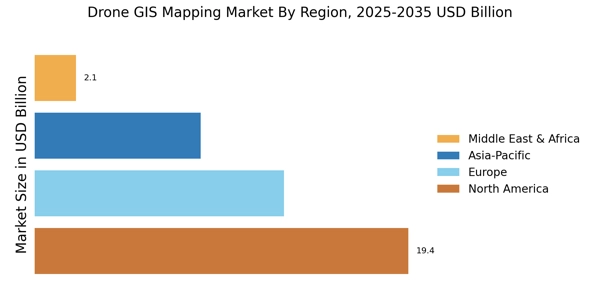
    North America is expected to hold the largest share of the Drone GIS Mapping market in 2023.

    Which application segment is expected to have the highest growth rate in the Drone GIS Mapping Market?

    The infrastructure monitoring segment is expected to have the highest growth rate in the Drone GIS Mapping market.

    Who are some of the key competitors in the Drone GIS Mapping Market?

    Some of the key competitors in the Drone GIS Mapping market include DJI, Skydio, senseFly, and PrecisionHawk.

    What are some of the growth drivers for the Drone GIS Mapping Market?

    Some of the growth drivers for the Drone GIS Mapping market include the increasing adoption of drones for mapping and surveying, the growing demand for accurate and up-to-date geospatial data, and the increasing use of GIS technology in various industries.

    What are some of the challenges facing the Drone GIS Mapping Market?

    Some of the challenges facing the Drone GIS Mapping market include the high cost of drones, the need for specialized skills to operate drones, and the regulatory restrictions on the use of drones in some areas.

    What is the expected market size of the Drone GIS Mapping Market in 2032?

    The Drone GIS Mapping market is expected to reach USD 174.32 billion by 2032.

    Which region is expected to have the highest growth rate in the Drone GIS Mapping Market between 2024 and 2032?

    The Asia Pacific region is expected to have the highest growth rate in the Drone GIS Mapping market between 2024 and 2032.

    What are some of the key trends in the Drone GIS Mapping Market?

    Some of the key trends in the Drone GIS Mapping market include the increasing use of AI and machine learning in drones, the development of new drone technologies, and the growing adoption of drones in various industries.

    Download Free Sample

    Kindly complete the form below to receive a free sample of this Report

    Case Study
    Chemicals and Materials