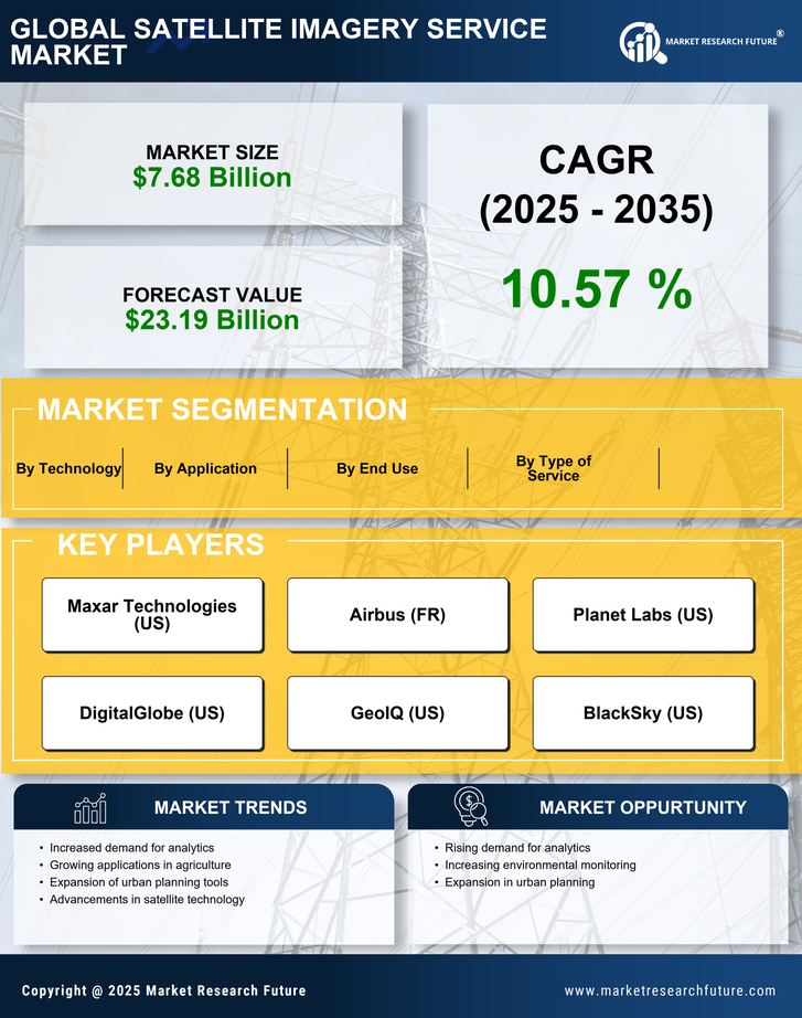
Growing Demand for Geospatial Data
The Satellite Imagery Service Market is witnessing an escalating demand for geospatial data, driven by the need for informed decision-making in various sectors. Industries such as agriculture, forestry, and disaster management are increasingly relying on satellite imagery to optimize operations and enhance efficiency. According to recent estimates, the demand for geospatial data is expected to grow at a compound annual growth rate of around 15% over the next five years. This trend is largely attributed to the increasing adoption of location-based services and the integration of satellite data with other data sources. As organizations seek to leverage geospatial insights for strategic planning, the Satellite Imagery Service Market is poised for substantial growth.
Regulatory and Collaborative Initiatives
The Satellite Imagery Service Market is influenced by various regulatory and collaborative initiatives that aim to standardize data usage and promote transparency. Governments and international organizations are increasingly recognizing the importance of satellite data for environmental monitoring, disaster response, and urban planning. Initiatives such as the Open Data Cube project are fostering collaboration among stakeholders, enabling the sharing of satellite data for public good. These efforts not only enhance the credibility of satellite imagery but also encourage investment in the sector. As regulatory frameworks evolve, they are likely to create a more conducive environment for the growth of the Satellite Imagery Service Market, potentially leading to increased partnerships between public and private entities.
Increased Investment in Earth Observation
The Satellite Imagery Service Market is benefiting from increased investment in Earth observation technologies. Governments and private entities are recognizing the strategic importance of satellite data for national security, environmental monitoring, and resource management. Recent reports indicate that investment in Earth observation satellites is expected to exceed 3 billion USD annually by 2025. This influx of capital is likely to accelerate the development of new satellite systems and enhance existing capabilities. As more satellites are launched, the availability of high-quality imagery will expand, further driving the growth of the Satellite Imagery Service Market. This trend suggests a promising future for companies involved in satellite data acquisition and analysis.
Rising Applications Across Various Sectors
The Satellite Imagery Service Market is experiencing a rise in applications across diverse sectors, including agriculture, urban planning, and climate change monitoring. The versatility of satellite imagery allows for its utilization in precision farming, where farmers can optimize crop yields through detailed land analysis. Additionally, urban planners are leveraging satellite data to monitor urban sprawl and infrastructure development. The market for satellite imagery services is projected to grow significantly, with applications in climate change adaptation and disaster management becoming increasingly critical. As awareness of the benefits of satellite imagery spreads, the demand for these services is likely to expand, further solidifying the Satellite Imagery Service Market as a vital component of modern data-driven decision-making.
Technological Advancements in Satellite Imagery
The Satellite Imagery Service Market is experiencing a surge in technological advancements that enhance the quality and accessibility of satellite data. Innovations in sensor technology, data processing algorithms, and machine learning applications are driving this growth. For instance, the introduction of high-resolution imaging satellites has improved the precision of geospatial data, making it invaluable for various sectors such as agriculture, urban planning, and environmental monitoring. The market is projected to reach a valuation of approximately 8 billion USD by 2026, indicating a robust demand for advanced satellite imagery services. These advancements not only facilitate better data collection but also enable real-time analytics, which is becoming increasingly essential for decision-making processes across industries.