• Cat-intel
  • MedIntelliX
  • Resources
  • About Us
  • Request Free Sample ×

    Kindly complete the form below to receive a free sample of this Report

    Leading companies partner with us for data-driven Insights

    clients tt-cursor
    Hero Background

    Terrestrial Laser Scanning Market

    ID: MRFR/A&D/31256-HCR
    100 Pages
    Sejal Akre
    October 2025

    Terrestrial Laser Scanning Market Research Report: By Application (Construction, Civil Engineering, Heritage Preservation, Mining, Forestry), By Scanning Method (Ground-Based Laser Scanning, Airborne Laser Scanning, Mobile Laser Scanning, Terrestrial Laser Scanning), By End Use (Architecture, Land Surveying, Agriculture, Environmental Monitoring, Transportation), By Component (Hardware, Software, Services) and By Regional (North America, Europe, South America, Asia Pacific, Middle East and Africa) - Forecast to 2035.

    Share:
    Download PDF ×

    We do not share your information with anyone. However, we may send you emails based on your report interest from time to time. You may contact us at any time to opt-out.

    Terrestrial Laser Scanning Market
 Infographic
    Purchase Options

    Terrestrial Laser Scanning Market Summary

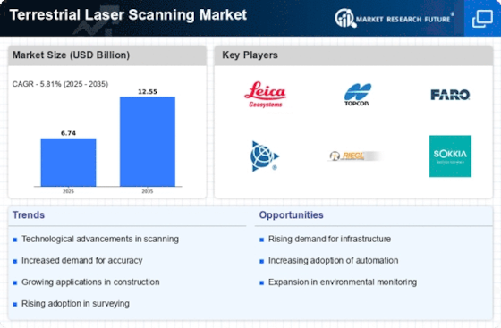
    As per MRFR analysis, the Terrestrial Laser Scanning Market Size was estimated at 6.741 USD Billion in 2024. The Terrestrial Laser Scanning industry is projected to grow from 7.133 USD Billion in 2025 to 12.55 USD Billion by 2035, exhibiting a compound annual growth rate (CAGR) of 5.81 during the forecast period 2025 - 2035.

    Key Market Trends & Highlights

    <p>The Terrestrial Laser Scanning Market is poised for substantial growth driven by technological advancements and increased adoption across various sectors.</p>

    • North America remains the largest market for terrestrial laser scanning, driven by robust demand in construction and civil engineering.
    • The Asia-Pacific region is emerging as the fastest-growing market, fueled by rapid urbanization and infrastructure development.
    • The construction segment leads in market share, while the civil engineering segment is witnessing the fastest growth due to increasing project complexities.
    • Technological advancements and a growing focus on environmental compliance are key drivers propelling the adoption of terrestrial laser scanning solutions.

    Market Size & Forecast

    2024 Market Size 6.741 (USD Billion)
    2035 Market Size 12.55 (USD Billion)
    CAGR (2025 - 2035) 5.81%

    Major Players

    Leica Geosystems (CH), Topcon Positioning Systems (US), Faro Technologies (US), Trimble Inc. (US), Riegl Laser Measurement Systems (AT), Zoller + Fröhlich (DE), Sokkia (JP), GeoSLAM (GB), 3D Laser Mapping (GB)

    Terrestrial Laser Scanning Market Trends

    The Terrestrial Laser Scanning Market is currently experiencing a notable evolution, driven by advancements in technology and increasing demand across various sectors. This market encompasses a range of applications, including construction, surveying, and environmental monitoring. As organizations seek to enhance accuracy and efficiency in their projects, the adoption of terrestrial laser scanning solutions appears to be on the rise. The integration of these systems into workflows is likely to streamline processes, reduce costs, and improve overall project outcomes. Furthermore, the growing emphasis on data-driven decision-making suggests that the market will continue to expand as more industries recognize the value of precise three-dimensional data capture. In addition to technological advancements, the Terrestrial Laser Scanning Market is influenced by regulatory frameworks and environmental considerations. As governments worldwide implement stricter regulations regarding land use and environmental protection, the demand for accurate mapping and monitoring tools is expected to increase. This trend may lead to greater investment in terrestrial laser scanning technologies, as organizations strive to comply with these regulations while also enhancing their operational capabilities. Overall, the market appears poised for growth, with a diverse range of applications and a strong focus on innovation and compliance driving its trajectory.

    Technological Advancements

    The Terrestrial Laser Scanning Market is witnessing rapid technological advancements that enhance the capabilities of scanning devices. Innovations in sensor technology, data processing, and software integration are enabling more accurate and efficient data collection. As these technologies evolve, they are likely to improve the overall user experience and broaden the range of applications for terrestrial laser scanning.

    Increased Adoption in Various Industries

    There is a growing trend of increased adoption of terrestrial laser scanning across various industries, including construction, mining, and heritage preservation. Organizations are recognizing the benefits of precise measurements and detailed 3D models, which facilitate better planning and execution of projects. This trend suggests a shift towards more data-driven approaches in these sectors.

    Focus on Environmental Compliance

    The emphasis on environmental compliance is shaping the Terrestrial Laser Scanning Market. As regulations become more stringent, industries are seeking advanced tools for accurate land assessment and monitoring. This focus on compliance may drive demand for terrestrial laser scanning solutions, as they provide essential data for environmental impact assessments and sustainable practices.

    The increasing adoption of terrestrial laser scanning technology across various sectors suggests a transformative shift in how spatial data is captured and utilized, enhancing precision and efficiency in projects ranging from construction to environmental monitoring.

    U.S. Geological Survey (USGS)

    Terrestrial Laser Scanning Market Drivers

    Focus on Environmental Compliance

    The Terrestrial Laser Scanning Market is increasingly influenced by the growing emphasis on environmental compliance and sustainability. Organizations are under pressure to adhere to regulations that require accurate environmental assessments and monitoring. Terrestrial laser scanning provides a non-invasive method for collecting data on land use, vegetation, and topography, which is essential for environmental impact assessments. The ability to generate high-resolution 3D models facilitates better decision-making regarding land development and conservation efforts. As regulatory frameworks become more stringent, the demand for terrestrial laser scanning solutions is expected to rise. This trend is likely to contribute to a market growth rate of around 12% annually, as companies seek to leverage these technologies to meet compliance requirements and enhance their sustainability initiatives.

    Increased Adoption in Various Industries

    The Terrestrial Laser Scanning Market is witnessing a surge in adoption across multiple sectors, including architecture, engineering, and construction. This trend is largely attributed to the need for precise measurements and detailed documentation in project planning and execution. For example, the construction industry has increasingly integrated terrestrial laser scanning into workflows to enhance project accuracy and reduce rework. Reports indicate that the market for terrestrial laser scanning in construction alone is expected to reach USD 1.2 billion by 2026. Furthermore, industries such as heritage preservation and urban planning are also recognizing the value of these technologies for capturing detailed site information. As more sectors realize the benefits of terrestrial laser scanning, the market is likely to expand further, driven by diverse applications.

    Growing Demand for 3D Modeling and Visualization

    The Terrestrial Laser Scanning Market is experiencing a growing demand for 3D modeling and visualization capabilities. As industries increasingly rely on accurate representations of physical spaces, the need for high-quality 3D models has surged. Terrestrial laser scanning provides detailed and precise data that can be transformed into 3D visualizations, aiding in design, analysis, and presentation. This trend is particularly evident in sectors such as architecture and construction, where stakeholders require realistic models for project planning and client presentations. The market for 3D modeling solutions is expected to grow at a rate of 10% annually, driven by the increasing reliance on visual data in decision-making processes. As organizations seek to enhance their project outcomes, the demand for terrestrial laser scanning technologies that support 3D modeling is likely to continue to rise.

    Integration with Geographic Information Systems (GIS)

    The Terrestrial Laser Scanning Market is benefiting from the integration of laser scanning technologies with Geographic Information Systems (GIS). This synergy allows for the creation of comprehensive spatial data that enhances analysis and visualization capabilities. By combining high-resolution 3D data from terrestrial laser scanners with GIS platforms, organizations can achieve more informed decision-making in urban planning, infrastructure development, and resource management. The market for GIS-integrated terrestrial laser scanning solutions is projected to grow significantly, as more entities recognize the advantages of this integration. It is estimated that the GIS market will reach USD 12 billion by 2027, with a substantial portion attributed to advancements in terrestrial laser scanning technologies. This integration not only improves data accuracy but also streamlines workflows, making it a key driver in the market.

    Technological Advancements in Terrestrial Laser Scanning

    The Terrestrial Laser Scanning Market is experiencing rapid technological advancements that enhance the precision and efficiency of data collection. Innovations such as improved sensor technology and software integration are enabling more accurate 3D modeling and analysis. For instance, the introduction of high-speed laser scanners has reduced data acquisition time significantly, allowing for real-time processing and analysis. This has led to increased demand across various sectors, including construction, mining, and environmental monitoring. The market is projected to grow at a compound annual growth rate of approximately 15% over the next five years, driven by these technological improvements. As organizations seek to optimize their operations and reduce costs, the adoption of advanced terrestrial laser scanning solutions is likely to become more prevalent.

    Market Segment Insights

    By By Application: Construction (Largest) vs. Civil Engineering (Fastest-Growing)

    In the Terrestrial Laser Scanning Market, the application segment reflects diverse utilization across various industries. Notably, the construction sector commands a substantial share, leveraging terrestrial laser scanning for precision and efficiency in project execution. Meanwhile, civil engineering emerges as a noteworthy contender, utilizing TLS for intricate project designs and maintenance, indicating a growing adoption rate within this application area. The growth trends reveal a significant shift as sectors like heritage preservation and mining increasingly adopt terrestrial laser scanning technologies. This transition is driven by the need for accuracy in surveying and mapping, ensuring heritage sites are meticulously documented and mining operations are optimized for safety and efficiency. The overarching trend points to a rising awareness and integration of TLS across industries, influencing future growth trajectories.

    Construction (Dominant) vs. Heritage Preservation (Emerging)

    In the Terrestrial Laser Scanning Market, construction stands out as the dominant application, widely recognized for its ability to enhance accuracy, efficiency, and cost-effectiveness in project management. This sector employs TLS to create detailed 3D models that aid in planning and design, ensuring optimal resource allocation and project timelines. On the other hand, heritage preservation is an emerging application gaining momentum, recognizing the importance of accurately capturing and conserving historical sites. The integration of TLS in this field allows for detailed documentation and analysis, supporting the conservation efforts while also attracting future investments. Both segments showcase unique characteristics, with construction driven by rapid project demands and heritage preservation focused on cultural significance and sustainability.

    By By Scanning Method: Ground-Based Laser Scanning (Largest) vs. Airborne Laser Scanning (Fastest-Growing)

    In the Terrestrial Laser Scanning Market, Ground-Based Laser Scanning holds the largest market share, primarily due to its extensive applicability across various industries such as construction, archaeology, and mining. This method provides high precision and detailed imaging, making it the preferred choice for many professionals. Meanwhile, Airborne Laser Scanning is gaining traction, owing to its ability to capture large areas efficiently, appealing to sectors such as forestry, agriculture, and urban planning.

    Scanning Technology: Ground-Based (Dominant) vs. Airborne (Emerging)

    Ground-Based Laser Scanning is recognized for its accuracy and versatility, frequently employed in structural monitoring and CAD modeling. Its dominance in the market is driven by the demand for detailed terrain mapping and building assessments. On the other hand, Airborne Laser Scanning is more oriented towards large-scale data collection, enabling rapid assessment of extensive geographic areas. As technology advances, the efficiency and cost-effectiveness of airborne methods are making them increasingly attractive, positioning them as a vital emerging segment in the Terrestrial Laser Scanning Market.

    By By End Use: Architecture (Largest) vs. Land Surveying (Fastest-Growing)

    In the Terrestrial Laser Scanning Market, the architecture sector holds the largest market share, driven by the increasing adoption of advanced technologies in building design and construction processes. This segment is widely utilized for creating detailed 3D models and enhancing project efficiency, leading to its substantial demand among architects and construction professionals. On the other hand, the land surveying sector is witnessing rapid growth, attributed to the rising need for precise mapping and land assessments in various industries, including infrastructure development.

    Architecture (Dominant) vs. Land Surveying (Emerging)

    The architecture segment of the Terrestrial Laser Scanning Market is characterized by its reliance on cutting-edge technologies that improve project outcomes through detailed visualization and accurate data collection. Architects increasingly utilize laser scanning for site documentation, allowing for comprehensive analysis and efficient planning. In contrast, the land surveying sector is emerging rapidly as it responds to the growing requirements for geospatial data in construction and urban planning. This segment benefits from technological advancements that enhance measurement accuracy and speed, making it a crucial element in modern surveying practices.

    By By Component: Hardware (Largest) vs. Software (Fastest-Growing)

    In the Terrestrial Laser Scanning Market, the component segment is primarily dominated by hardware, accounting for the largest share of the segment due to its fundamental role in capturing high-resolution 3D data. The hardware category includes components such as scanners, tripods, and batteries, which are essential for efficient scanning operations. On the other hand, software solutions are gaining traction, driven by the need for advanced data processing and analysis capabilities, making them the fastest-growing segment within the industry.

    Components: Hardware (Dominant) vs. Software (Emerging)

    The hardware component stands out as the dominant force in the Terrestrial Laser Scanning Market, characterized by robust technological advancements and a wide range of applications across industries such as construction, mining, and archaeology. These hardware solutions not only provide critical data acquisition but also enhance efficiency and accuracy in projects. Conversely, the software segment is emerging rapidly, fueled by the increasing demand for sophisticated analysis tools that can handle large volumes of scanning data. Enhanced functionalities like integration with GIS and advanced modeling make software an attractive investment for companies aiming to leverage the full potential of laser scanning technologies. Together, these segments are essential in shaping the future landscape of terrestrial laser scanning.

    Get more detailed insights about Terrestrial Laser Scanning Market

    Regional Insights

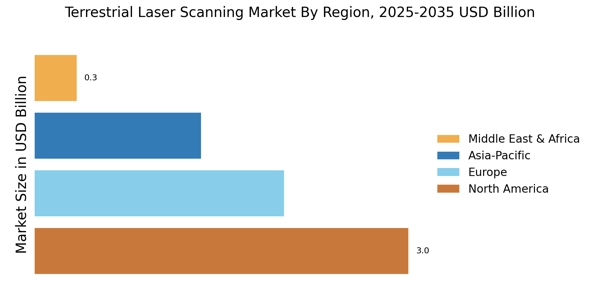
    North America : Technological Innovation Leader

    North America is the largest market for terrestrial laser scanning, holding approximately 45% of the global share. The region's growth is driven by advancements in technology, increasing demand for 3D modeling, and significant investments in infrastructure projects. Regulatory support for construction and surveying activities further catalyzes market expansion. The U.S. and Canada are the primary contributors, with a strong focus on integrating laser scanning in various sectors. The competitive landscape in North America is robust, featuring key players like Leica Geosystems, Topcon Positioning Systems, and Faro Technologies. These companies are at the forefront of innovation, offering advanced solutions that cater to diverse applications, including construction, mining, and environmental monitoring. The presence of established firms and a growing number of startups enhances the region's market dynamics, fostering a culture of continuous improvement and technological advancement.

    Europe : Emerging Market with Growth Potential

    Europe is witnessing significant growth in the terrestrial laser scanning market, accounting for approximately 30% of the global share. The region benefits from stringent regulations promoting safety and accuracy in construction and surveying, driving demand for advanced scanning technologies. Countries like Germany and the UK are leading the market, supported by government initiatives aimed at enhancing infrastructure and urban planning. Germany stands out as a key player, with companies like Zoller + Fröhlich and Riegl Laser Measurement Systems leading the charge. The competitive landscape is characterized by a mix of established firms and innovative startups, fostering a dynamic environment for technological advancements. The European market is also increasingly focusing on sustainability, integrating laser scanning solutions to improve efficiency and reduce environmental impact.

    Asia-Pacific : Rapidly Growing Market

    Asia-Pacific is emerging as a significant player in the terrestrial laser scanning market, holding around 20% of the global share. The region's growth is fueled by rapid urbanization, increasing investments in infrastructure, and a rising demand for precision in surveying and construction. Countries like China and Japan are at the forefront, with government initiatives supporting technological adoption and innovation in various sectors. China, in particular, is witnessing a surge in demand for laser scanning technologies, driven by large-scale construction projects and urban development. Key players such as Sokkia and GeoSLAM are actively expanding their presence in the region, contributing to a competitive landscape that encourages innovation. The focus on smart cities and digital transformation further propels the adoption of terrestrial laser scanning solutions across various industries.

    Middle East and Africa : Emerging Market with Unique Challenges

    The Middle East and Africa region is gradually developing its terrestrial laser scanning market, accounting for approximately 5% of the global share. The growth is primarily driven by increasing investments in infrastructure and construction projects, particularly in the Gulf Cooperation Council (GCC) countries. Regulatory frameworks are evolving to support the adoption of advanced technologies, although challenges remain in terms of market maturity and technological awareness. Countries like the UAE and South Africa are leading the way, with significant projects that require precise surveying and mapping solutions. The competitive landscape is still developing, with a mix of local and international players entering the market. Companies are focusing on educating potential clients about the benefits of laser scanning technologies, which is crucial for market expansion in this region.

    Key Players and Competitive Insights

    The Terrestrial Laser Scanning Market is currently characterized by a dynamic competitive landscape, driven by technological advancements and increasing demand for precision in various sectors such as construction, surveying, and environmental monitoring. Key players like Leica Geosystems (Switzerland), Trimble Inc. (US), and Faro Technologies (US) are at the forefront, each adopting distinct strategies to enhance their market positioning. Leica Geosystems (Switzerland) emphasizes innovation through continuous product development, focusing on integrating advanced software solutions with their hardware offerings. Trimble Inc. (US) appears to be pursuing a strategy of regional expansion, particularly in emerging markets, while Faro Technologies (US) is concentrating on digital transformation initiatives to streamline operations and improve customer engagement. Collectively, these strategies contribute to a competitive environment that is increasingly focused on technological differentiation and customer-centric solutions.

    In terms of business tactics, companies are increasingly localizing manufacturing to reduce costs and enhance supply chain efficiency. The market structure is moderately fragmented, with several players vying for market share, yet the influence of major companies remains substantial. This fragmentation allows for niche players to emerge, but the collective strength of key players like Leica and Trimble shapes the overall market dynamics, pushing for higher standards and innovation.

    In August 2025, Leica Geosystems (Switzerland) launched a new line of high-precision laser scanners designed specifically for urban planning applications. This strategic move not only reinforces their commitment to innovation but also positions them to capture a growing segment of the market that requires advanced solutions for complex urban environments. The introduction of these scanners is likely to enhance their competitive edge by addressing specific customer needs in urban development.

    In September 2025, Trimble Inc. (US) announced a partnership with a leading software firm to integrate AI capabilities into their terrestrial laser scanning solutions. This collaboration is significant as it indicates a shift towards incorporating artificial intelligence to enhance data processing and analysis, thereby improving the overall efficiency of surveying tasks. Such advancements may provide Trimble with a competitive advantage in a market that increasingly values speed and accuracy.

    In October 2025, Faro Technologies (US) unveiled a new cloud-based platform that allows users to access and analyze laser scanning data in real-time. This development is crucial as it aligns with the growing trend towards digitalization in the industry, enabling users to make informed decisions quickly. By leveraging cloud technology, Faro is likely to enhance its service offerings and strengthen customer loyalty, which is essential in a competitive landscape.

    As of October 2025, the Terrestrial Laser Scanning Market is witnessing trends that emphasize digitalization, sustainability, and the integration of AI technologies. Strategic alliances are becoming increasingly important, as companies seek to combine their strengths to innovate and meet evolving customer demands. Looking ahead, competitive differentiation is expected to shift from traditional price-based competition to a focus on innovation, technological advancements, and reliable supply chains. This evolution suggests that companies that prioritize these aspects will likely emerge as leaders in the market.

    Key Companies in the Terrestrial Laser Scanning Market market include

    Industry Developments

    The Terrestrial Laser Scanning Market has been witnessing significant developments recently, particularly involving key players like Faro Technologies, Trimble, Velodyne Lidar, and Riegl Laser Measurement Systems.

    As industries increasingly adopt advanced 3D scanning technologies, there is a notable surge in demand for laser scanning solutions across the construction, mining, and surveying sectors.

    Companies such as Hexagon and Leica Geosystems are enhancing their product offerings to incorporate AI and automation, aiming to improve precision and efficiency. In terms of market activity, recent mergers and acquisitions have raised interest; for example, Teledyne Technologies has been active in expanding its portfolio through strategic acquisitions, while Topcon has sought to strengthen its market position by integrating innovative scanning technologies from smaller firms.

    Additionally, the overall market valuation has experienced growth as investments in research and development and advancements in laser scanning technology propel the sector forward.

    Organizations like GeoSLAM and Optech are also noted for their contributions, with new product launches aimed at enhancing user experience and meeting market demand for faster, more accurate scanning solutions. The focus on sustainability and environmental compliance is shaping future developments in the sector.

    Future Outlook

    Terrestrial Laser Scanning Market Future Outlook

    The Terrestrial Laser Scanning Market is projected to grow at a 5.81% CAGR from 2024 to 2035, driven by advancements in technology, increasing demand for precision, and expanding applications across industries.

    New opportunities lie in:

    • Development of integrated software solutions for real-time data analysis.
    • Expansion into emerging markets with tailored scanning services.
    • Partnerships with construction firms for enhanced project management solutions.

    By 2035, the Terrestrial Laser Scanning Market is expected to be robust, reflecting substantial growth and innovation.

    Market Segmentation

    Terrestrial Laser Scanning Market End Use Outlook

    • Architecture
    • Land Surveying
    • Agriculture
    • Environmental Monitoring
    • Transportation

    Terrestrial Laser Scanning Market Component Outlook

    • Hardware
    • Software
    • Services

    Terrestrial Laser Scanning Market Application Outlook

    • Construction
    • Civil Engineering
    • Heritage Preservation
    • Mining
    • Forestry

    Terrestrial Laser Scanning Market Scanning Method Outlook

    • Ground-Based Laser Scanning
    • Airborne Laser Scanning
    • Mobile Laser Scanning
    • Terrestrial Laser Scanning

    Report Scope

    MARKET SIZE 20246.741(USD Billion)
    MARKET SIZE 20257.133(USD Billion)
    MARKET SIZE 203512.55(USD Billion)
    COMPOUND ANNUAL GROWTH RATE (CAGR)5.81% (2024 - 2035)
    REPORT COVERAGERevenue Forecast, Competitive Landscape, Growth Factors, and Trends
    BASE YEAR2024
    Market Forecast Period2025 - 2035
    Historical Data2019 - 2024
    Market Forecast UnitsUSD Billion
    Key Companies ProfiledMarket analysis in progress
    Segments CoveredMarket segmentation analysis in progress
    Key Market OpportunitiesIntegration of artificial intelligence enhances data processing in the Terrestrial Laser Scanning Market.
    Key Market DynamicsTechnological advancements in terrestrial laser scanning enhance precision, driving demand across various industries and applications.
    Countries CoveredNorth America, Europe, APAC, South America, MEA

    Leave a Comment

    FAQs

    What is the projected market valuation for the Terrestrial Laser Scanning Market in 2035?

    The projected market valuation for the Terrestrial Laser Scanning Market in 2035 is 12.55 USD Billion.

    What was the overall market valuation for the Terrestrial Laser Scanning Market in 2024?

    The overall market valuation for the Terrestrial Laser Scanning Market in 2024 was 6.741 USD Billion.

    What is the expected CAGR for the Terrestrial Laser Scanning Market from 2025 to 2035?

    The expected CAGR for the Terrestrial Laser Scanning Market during the forecast period 2025 - 2035 is 5.81%.

    Which application segment is projected to have the highest valuation by 2035?

    The Construction application segment is projected to reach 2.8 USD Billion by 2035.

    How does the valuation of Ground-Based Laser Scanning compare to other scanning methods by 2035?

    By 2035, Ground-Based Laser Scanning is expected to reach 3.5 USD Billion, surpassing other scanning methods.

    What are the projected valuations for the Services component by 2035?

    The Services component is projected to reach 6.05 USD Billion by 2035.

    Which key players are leading the Terrestrial Laser Scanning Market?

    Key players in the Terrestrial Laser Scanning Market include Leica Geosystems, Topcon Positioning Systems, and Faro Technologies.

    What is the expected valuation for the Mining application segment by 2035?

    The Mining application segment is expected to reach 1.9 USD Billion by 2035.

    What is the projected valuation for the Environmental Monitoring end-use segment by 2035?

    The Environmental Monitoring end-use segment is projected to reach 1.2 USD Billion by 2035.

    How does the valuation of the Architecture end-use segment compare to others by 2035?

    The Architecture end-use segment is expected to reach 2.8 USD Billion by 2035, indicating strong growth.

    Download Free Sample

    Kindly complete the form below to receive a free sample of this Report

    Case Study
    Chemicals and Materials

    Compare Licence

    ×
    Features License Type
    Single User Multiuser License Enterprise User
    Price $4,950 $5,950 $7,250
    Maximum User Access Limit 1 User Upto 10 Users Unrestricted Access Throughout the Organization
    Free Customization
    Direct Access to Analyst
    Deliverable Format
    Platform Access
    Discount on Next Purchase 10% 15% 15%
    Printable Versions