×
Request Free Sample ×

Kindly complete the form below to receive a free sample of this Report

Leading companies partner with us for data-driven Insights

clients tt-cursor
Hero Background

Terrestrial Photogrammetry Software Market

ID: MRFR/ICT/36504-HCR
100 Pages
Anshula Mandaokar
October 2025

Terrestrial Photogrammetry Software Market Research Report: By Application (Mapping, Surveying, Construction, Environmental Monitoring), By Deployment Type (On-Premise, Cloud-Based, Hybrid), By End Use Industry (Construction, Mining, Agriculture, Transportation, Forestry), By Features (2D Mapping, 3D Modeling, Data Analysis, Real-Time Processing) and By Regional (North America, Europe, South America, Asia Pacific, Middle East and Africa) - Forecast to 2035

Share:
Download PDF ×

We do not share your information with anyone. However, we may send you emails based on your report interest from time to time. You may contact us at any time to opt-out.

Terrestrial Photogrammetry Software Market Infographic
Purchase Options

Terrestrial Photogrammetry Software Market Summary

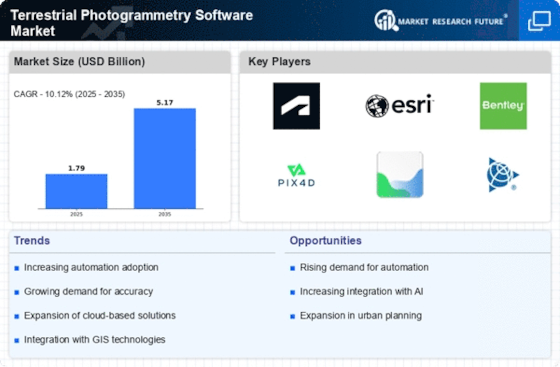
As per MRFR analysis, the Terrestrial Photogrammetry Software Market Size was estimated at 1.789 USD Billion in 2024. The Terrestrial Photogrammetry Software industry is projected to grow from 1.971 in 2025 to 5.168 by 2035, exhibiting a compound annual growth rate (CAGR) of 10.12 during the forecast period 2025 - 2035.

Key Market Trends & Highlights

The Terrestrial Photogrammetry Software Market is experiencing robust growth driven by technological advancements and increasing demand for precision in mapping solutions.

  • The integration of AI and machine learning technologies is transforming the capabilities of terrestrial photogrammetry software.
  • North America remains the largest market, while the Asia-Pacific region is emerging as the fastest-growing area for these solutions.
  • The surveying segment continues to dominate the market, whereas the mapping segment is witnessing the most rapid growth.
  • Key market drivers include the increasing demand for accurate mapping solutions and the adoption of smart city initiatives.

Market Size & Forecast

2024 Market Size 1.789 (USD Billion)
2035 Market Size 5.168 (USD Billion)
CAGR (2025 - 2035) 10.12%

Major Players

Autodesk (US), Esri (US), Bentley Systems (US), Pix4D (CH), Agisoft (RU), Trimble (US), Topcon (JP), Hexagon (SE), 3D Survey (AU)

Terrestrial Photogrammetry Software Market Trends

The Terrestrial Photogrammetry Software Market is currently experiencing a notable evolution, driven by advancements in technology and increasing demand for precise mapping solutions. This market encompasses software that utilizes terrestrial imagery to create detailed three-dimensional models and maps, which are essential in various sectors such as construction, urban planning, and environmental monitoring. The integration of artificial intelligence and machine learning into these software solutions appears to enhance their capabilities, allowing for more accurate data processing and analysis. Furthermore, the growing emphasis on sustainability and efficient resource management is likely to propel the adoption of terrestrial photogrammetry tools, as they facilitate better decision-making through improved visualization and data interpretation. In addition, the Terrestrial Photogrammetry Software Market seems to be influenced by the rising trend of remote sensing technologies. As industries increasingly seek to leverage aerial and terrestrial data for comprehensive insights, the demand for software that can seamlessly integrate and analyze this information is expected to grow. Moreover, the ongoing development of user-friendly interfaces and cloud-based solutions may further democratize access to these advanced tools, enabling a broader range of professionals to utilize photogrammetry in their work. Overall, the market is poised for continued growth, driven by technological innovations and an expanding user base across diverse applications.

Integration of AI and Machine Learning

The incorporation of artificial intelligence and machine learning into terrestrial photogrammetry software is transforming data processing capabilities. These technologies enhance the accuracy and efficiency of image analysis, enabling users to generate more precise models and maps. As a result, professionals in various fields are likely to benefit from improved decision-making tools.

Rise of Remote Sensing Technologies

The increasing utilization of remote sensing technologies is shaping the Terrestrial Photogrammetry Software Market. As industries seek to harness both aerial and terrestrial data, the demand for software that can effectively integrate and analyze this information is expected to rise. This trend indicates a shift towards more comprehensive data solutions.

User-Friendly Interfaces and Cloud Solutions

The development of user-friendly interfaces and cloud-based solutions is making terrestrial photogrammetry software more accessible. This trend may democratize the use of advanced mapping tools, allowing a wider range of professionals to engage with photogrammetry. Consequently, the market could see an expansion in its user base across various sectors.

Terrestrial Photogrammetry Software Market Drivers

Adoption of Smart City Initiatives

The Terrestrial Photogrammetry Software Market is significantly influenced by the global trend towards smart city initiatives. As urban areas strive to enhance infrastructure and service delivery, the demand for accurate spatial data becomes paramount. Photogrammetry software plays a crucial role in urban planning, enabling city planners to visualize and analyze spatial relationships effectively. The increasing investment in smart city projects, estimated to reach over 1 trillion dollars by 2030, underscores the importance of advanced mapping technologies. This trend not only drives the adoption of terrestrial photogrammetry software but also encourages collaboration among various stakeholders, including government agencies and private enterprises, to create integrated solutions that address urban challenges.

Advancements in Data Processing Technologies

The Terrestrial Photogrammetry Software Market is benefiting from rapid advancements in data processing technologies. Innovations in computing power and algorithms have enhanced the efficiency and accuracy of photogrammetric data processing. As a result, users can now generate high-quality 3D models and maps more quickly than ever before. The integration of cloud computing solutions further streamlines data storage and accessibility, allowing for real-time collaboration among users. This technological evolution is likely to attract a broader range of industries to adopt terrestrial photogrammetry software, as it becomes increasingly feasible to process large datasets efficiently. Consequently, the market is expected to witness a notable increase in adoption rates, driven by these technological improvements.

Increasing Demand for Accurate Mapping Solutions

The Terrestrial Photogrammetry Software Market is experiencing a surge in demand for precise mapping solutions across various sectors, including construction, agriculture, and urban planning. As industries increasingly rely on accurate geographical data for decision-making, the need for advanced photogrammetry software becomes evident. The market is projected to grow at a compound annual growth rate (CAGR) of approximately 12% over the next five years, driven by the necessity for high-resolution mapping and modeling. This growth is further fueled by the integration of advanced technologies, such as drones and 3D scanning, which enhance the capabilities of terrestrial photogrammetry software. Consequently, businesses are investing in these solutions to improve operational efficiency and reduce costs, indicating a robust trajectory for the industry.

Growth in Environmental Monitoring and Management

The Terrestrial Photogrammetry Software Market is poised for growth due to the rising emphasis on environmental monitoring and management. As concerns about climate change and natural resource depletion intensify, organizations are increasingly utilizing photogrammetry software to assess and manage environmental impacts. This software enables the collection of detailed spatial data, facilitating the monitoring of land use changes, vegetation health, and natural disaster impacts. The market for environmental monitoring solutions is expected to expand significantly, with projections indicating a growth rate of around 10% annually. This trend highlights the critical role of terrestrial photogrammetry software in supporting sustainable practices and informed decision-making in environmental management.

Rising Popularity of Augmented Reality Applications

The Terrestrial Photogrammetry Software Market is experiencing a notable impact from the rising popularity of augmented reality (AR) applications. As industries such as real estate, gaming, and education explore the potential of AR, the demand for accurate 3D models generated through photogrammetry is on the rise. These applications require precise spatial data to create immersive experiences, thereby driving the need for advanced terrestrial photogrammetry software. The market for AR is projected to grow significantly, with estimates suggesting a value of over 200 billion dollars by 2025. This trend indicates a promising opportunity for photogrammetry software providers to cater to the evolving needs of various sectors, ultimately contributing to the expansion of the industry.

Market Segment Insights

By Application: Surveying (Largest) vs. Mapping (Fastest-Growing)

In the Terrestrial Photogrammetry Software Market, the application segment's landscape is significantly diverse with key players in surveying, mapping, construction, and environmental monitoring. Surveying is identified as the largest segment, capturing a substantial portion of the market share due to its pivotal role in various industries such as civil engineering and land development. Meanwhile, mapping emerges as the fastest-growing application, showing remarkable demand owing to the integration of advanced technologies in geographical information systems and urban planning initiatives.

Mapping (Emerging) vs. Surveying (Dominant)

The mapping segment is rapidly establishing itself as an emerging player within the Terrestrial Photogrammetry Software Market, driven by advancements in mobile mapping technology and the increasing need for accurate geographical data. It is particularly leveraged for urban planning and environmental assessments. Conversely, the surveying segment remains dominant, foundational for construction projects and land surveying, continuing to be heavily utilized across various sectors including mining and agriculture. Both segments are essential, but their market presence varies, with mapping increasingly catering to innovative applications.

By Deployment Type: Cloud-Based (Largest) vs. On-Premise (Fastest-Growing)

In the Terrestrial Photogrammetry Software Market, deployment types exhibit varying market share distributions. The Cloud-Based segment dominates the market, driven by its scalability, accessibility, and ease of integration with other digital tools. Meanwhile, the On-Premise segment remains a strong contender, appealing to organizations with stringent data security requirements who prefer to maintain direct control over their software and data management processes. The Hybrid deployment is also gaining traction as organizations seek to blend the advantages of both Cloud-Based and On-Premise models.

Deployment Types: Cloud-Based (Dominant) vs. Hybrid (Emerging)

The Cloud-Based deployment model leads the Terrestrial Photogrammetry Software Market due to its flexibility, cost-effectiveness, and ease of collaboration, making it particularly attractive for companies looking to streamline operations and enhance productivity. In contrast, the Hybrid deployment model is emerging as a viable option for businesses that require a combination of both Cloud resources and On-Premise infrastructure. This model allows organizations to leverage the benefits of the Cloud while addressing specific regulatory or operational challenges that necessitate On-Premise solutions. As the market evolves, both segments are expected to grow, driven by advancements in technology and changing user preferences.

By End Use Industry: Construction (Largest) vs. Agriculture (Fastest-Growing)

In the Terrestrial Photogrammetry Software Market, the end use industry segment is primarily dominated by the construction sector, which holds the largest share due to its extensive applications in planning and surveying. This sector leverages photogrammetry for enhanced precision and efficiency in designing infrastructure projects and managing construction sites. Other significant sectors include mining, transportation, forestry, and agriculture, each utilizing photogrammetry for various applications, yet they hold smaller market shares in comparison to construction. The agriculture sector, however, is witnessing rapid growth as farmers increasingly adopt photogrammetry techniques for crop monitoring, land surveying, and yield prediction. Enhanced technological integration, coupled with the need for more efficient resource management, is driving growth in this segment. Moreover, as sustainability practices gain traction, agriculture's reliance on data-driven insights through terrestrial photogrammetry is expected to rise significantly in the coming years.

Construction (Dominant) vs. Transportation (Emerging)

In the Terrestrial Photogrammetry Software Market, the construction sector stands out as the dominant end user due to its reliance on advanced surveying techniques for project management and quality control. It employs photogrammetry to create detailed models, streamline workflows, and reduce costs associated with traditional surveying methods. On the other hand, the transportation sector is emerging rapidly as it incorporates photogrammetry for infrastructure development, traffic management, and transportation planning. Adoption is fueled by the need for improved safety measures and efficient routing solutions. The intersection of technology and transportation infrastructure is significant, as photogrammetry offers precise analytics that enhance operational efficiency. While construction remains a robust sector, transportation is on the rise, indicating a shift towards more integrated approaches in project execution.

By Features: 3D Modeling (Largest) vs. Real-Time Processing (Fastest-Growing)

In the Terrestrial Photogrammetry Software Market, the distribution of market share among segment values reveals that 3D Modeling holds the largest share, being widely adopted across various applications such as construction, architecture, and urban planning. 2D Mapping and Data Analysis follow, catering to specific user needs, while Real-Time Processing is gaining traction due to its ability to provide immediate results, making it crucial for time-sensitive projects. As photogrammetry technology evolves, the need for efficiency and accuracy also heightens, contributing to the diverse share distribution among these features.

3D Modeling (Dominant) vs. Real-Time Processing (Emerging)

3D Modeling stands out as the dominant feature in the Terrestrial Photogrammetry Software Market, characterized by its extensive use in generating detailed three-dimensional representations crucial for various industries, including surveying and GIS. It offers users unparalleled visualization and analysis capabilities, making it essential for professional applications. In contrast, Real-Time Processing is emerging rapidly, driven by advancements in computing technology and the growing demand for immediate outputs in applications like drone surveying and environmental monitoring. This feature facilitates on-the-go decision-making and increases productivity, positioning it as a key driver for market innovation and change.

Get more detailed insights about Terrestrial Photogrammetry Software Market

Regional Insights

North America : Innovation and Leadership Hub

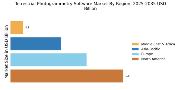
North America is the largest market for terrestrial photogrammetry software, holding approximately 45% of the global market share. The region's growth is driven by advancements in technology, increasing demand for 3D modeling, and supportive regulatory frameworks. The integration of photogrammetry in various sectors, including construction and agriculture, further fuels this demand. The U.S. leads the market, followed by Canada, which contributes significantly to the overall growth.

Europe : Technological Advancement and Adoption

Europe is the second-largest market for terrestrial photogrammetry software, accounting for around 30% of the global share. The region benefits from stringent regulations promoting sustainable practices and technological innovation. Countries like Germany and the UK are at the forefront, leveraging photogrammetry for urban planning and environmental monitoring. The competitive landscape is marked by the presence of key players such as Autodesk and Bentley Systems, driving further adoption of advanced solutions.

Asia-Pacific : Emerging Market Potential

Asia-Pacific is witnessing rapid growth in the terrestrial photogrammetry software market, driven by increasing investments in infrastructure and urban development. Countries like China and India are leading this growth, with a rising demand for accurate mapping and surveying solutions. The region's market share is estimated to be around 20%, with significant contributions from both public and private sectors. The competitive landscape is evolving, with local players emerging alongside established global firms.

Middle East and Africa : Resource-Rich Opportunities

The Middle East and Africa region is gradually expanding its terrestrial photogrammetry software market, holding about 5% of the global share. The growth is primarily driven by increasing investments in infrastructure projects and urban development initiatives. Countries like the UAE and South Africa are leading the charge, utilizing photogrammetry for construction and environmental management. The competitive landscape is characterized by a mix of local and international players, enhancing market dynamics.

Terrestrial Photogrammetry Software Market Regional Image

Key Players and Competitive Insights

The Terrestrial Photogrammetry Software Market has been experiencing significant growth as technological advancements in mapping and surveying gain traction across various industries. This market encompasses a wide range of software solutions that facilitate the conversion of images into accurate 3D models and maps. 

The competitive landscape is characterized by a diverse range of players, including established firms and emerging new entrants, each striving to innovate and enhance their product offerings to capture a larger market share. The evolution of cloud computing, artificial intelligence, and machine learning is influencing the development of photogrammetry tools, making them more efficient and user-friendly. 

Companies are focused on integrating new features such as real-time data processing and improved accuracy to maintain a competitive edge, driven by the increasing demand for precise geographic information systems in sectors like construction, agriculture, and environmental management.Agisoft has established a strong presence in the Terrestrial Photogrammetry Software Market, gaining recognition for its innovative software solutions that cater to a diverse clientele. 

The company’s flagship products excel in processing aerial and terrestrial imagery to create detailed 3D models and orthophotos. Agisoft's strengths lie in its user-friendly interface, robust analytical capabilities, and the ability to handle large datasets efficiently. The company emphasizes continuous improvements and updates to its software, which enhances its functionality and performance, ensuring it remains relevant in a rapidly evolving industry. 

Additionally, Agisoft initiates strong customer support and training programs to facilitate user adoption, further reinforcing its position as a key player in this market.Esri is a formidable competitor in the Terrestrial Photogrammetry Software Market, primarily known for its geospatial analysis and mapping solutions. The company's ArcGIS platform integrates photogrammetry tools that allow users to generate high-quality spatial data from images seamlessly. Esri stands out due to its extensive ecosystem, which supports a variety of GIS applications, making it a preferred choice for urban planners, environmentalists, and engineers. 

The strength of Esri lies in its ability to provide comprehensive solutions that not only address photogrammetric needs but also integrate them into broader geographic information systems. With a strong commitment to innovation and collaboration with academic institutions, Esri continually enhances its offerings, ensuring that users benefit from the latest advancements in technology and methodologies, thus bolstering its competitive standing in the market.

Key Companies in the Terrestrial Photogrammetry Software Market market include

Industry Developments

The Terrestrial Photogrammetry Software Market has observed considerable activity recently, particularly with advancements in technologies being adopted by key players such as Agisoft, Esri, and Pix4D. Companies are increasingly focusing on integrating artificial intelligence and machine learning capabilities to enhance data processing and analytics. Notably, 3D Robotics has expanded its offerings with a new software update that improves UAV data integration for more effective mapping solutions. 

In terms of mergers and acquisitions, Bentley Systems has reportedly made strategic acquisitions to bolster its capabilities, aiming to strengthen its position in the market. Furthermore, Hexagon Geospatial has been actively enhancing its product line to cater to the rising demand for 3D modeling solutions across various industries. 

The valuation of companies within this market is on the rise due to the growing applications in sectors such as construction, mining, and urban planning, indicating a robust demand for efficient photogrammetry solutions. Collaborations are also gaining traction, with multiple organizations seeking partnerships to leverage each other’s technological strengths for innovative solutions. This dynamic environment is setting the stage for expanded capabilities in photogrammetry applications.

Future Outlook

Terrestrial Photogrammetry Software Market Future Outlook

The Terrestrial Photogrammetry Software Market is projected to grow at a 10.12% CAGR from 2024 to 2035, driven by advancements in technology, increasing demand for accurate mapping, and integration with AI.

New opportunities lie in:

  • Development of cloud-based photogrammetry solutions for remote collaboration.
  • Expansion into emerging markets with tailored software packages.
  • Integration of machine learning algorithms for enhanced data analysis capabilities.

By 2035, the market is expected to be robust, driven by innovation and diverse applications.

Market Segmentation

Terrestrial Photogrammetry Software Market Features Outlook

  • 2D Mapping
  • 3D Modeling
  • Data Analysis
  • Real-Time Processing

Terrestrial Photogrammetry Software Market Application Outlook

  • Mapping
  • Surveying
  • Construction
  • Environmental Monitoring

Terrestrial Photogrammetry Software Market Deployment Type Outlook

  • On-Premise
  • Cloud-Based
  • Hybrid

Terrestrial Photogrammetry Software Market End Use Industry Outlook

  • Construction
  • Mining
  • Agriculture
  • Transportation
  • Forestry

Report Scope

MARKET SIZE 20241.789(USD Billion)
MARKET SIZE 20251.971(USD Billion)
MARKET SIZE 20355.168(USD Billion)
COMPOUND ANNUAL GROWTH RATE (CAGR)10.12% (2024 - 2035)
REPORT COVERAGERevenue Forecast, Competitive Landscape, Growth Factors, and Trends
BASE YEAR2024
Market Forecast Period2025 - 2035
Historical Data2019 - 2024
Market Forecast UnitsUSD Billion
Key Companies ProfiledMarket analysis in progress
Segments CoveredMarket segmentation analysis in progress
Key Market OpportunitiesIntegration of artificial intelligence enhances accuracy and efficiency in the Terrestrial Photogrammetry Software Market.
Key Market DynamicsTechnological advancements drive competitive dynamics in the Terrestrial Photogrammetry Software Market, enhancing data accuracy and processing efficiency.
Countries CoveredNorth America, Europe, APAC, South America, MEA

Leave a Comment

FAQs

What is the projected market valuation of the Terrestrial Photogrammetry Software Market by 2035?

The projected market valuation for the Terrestrial Photogrammetry Software Market is 5.168 USD Billion by 2035.

What was the market valuation of the Terrestrial Photogrammetry Software Market in 2024?

The overall market valuation was 1.789 USD Billion in 2024.

What is the expected CAGR for the Terrestrial Photogrammetry Software Market during the forecast period 2025 - 2035?

The expected CAGR for the Terrestrial Photogrammetry Software Market during the forecast period 2025 - 2035 is 10.12%.

Which companies are considered key players in the Terrestrial Photogrammetry Software Market?

Key players in the market include Autodesk, Esri, Bentley Systems, Pix4D, Agisoft, Trimble, Topcon, Hexagon, and 3D Survey.

What are the main application segments of the Terrestrial Photogrammetry Software Market?

The main application segments include Mapping, Surveying, Construction, and Environmental Monitoring.

How does the market valuation for the Mapping application segment change from 2024 to 2035?

The market valuation for the Mapping application segment is expected to grow from 0.537 USD Billion in 2024 to 1.525 USD Billion by 2035.

What is the anticipated growth in the Cloud-Based deployment type segment by 2035?

The Cloud-Based deployment type segment is projected to increase from 0.716 USD Billion in 2024 to 2.016 USD Billion by 2035.

Which end-use industries are driving the Terrestrial Photogrammetry Software Market?

The end-use industries driving the market include Construction, Mining, Agriculture, Transportation, and Forestry.

What is the expected market growth for the 3D Modeling feature from 2024 to 2035?

The expected market growth for the 3D Modeling feature is from 0.715 USD Billion in 2024 to 2.045 USD Billion by 2035.

How does the market for Environmental Monitoring compare to other application segments by 2035?

By 2035, the market for Environmental Monitoring is projected to reach 0.493 USD Billion, indicating a smaller scale compared to other segments like Mapping and Surveying.

Download Free Sample

Kindly complete the form below to receive a free sample of this Report

Compare Licence

×
Features License Type
Single User Multiuser License Enterprise User
Price $4,950 $5,950 $7,250
Maximum User Access Limit 1 User Upto 10 Users Unrestricted Access Throughout the Organization
Free Customization
Direct Access to Analyst
Deliverable Format
Platform Access
Discount on Next Purchase 10% 15% 15%
Printable Versions